
Station XM NM39 - NewMexico39
Network: XM99 - Rio Grande Seismic Transect
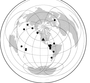
Nearby stations (2 deg radius)
| Station | Name | (Lat, Lon) | Start / End | Elevation |
| NM39 | NewMexico39 | (35.79, -108.27) | 1999-07-28 / 2001-12-31 | 1949 m |
| Crust2 Type: | H7,early/mid Proter. shield, Austr., 1.5 km seds. |
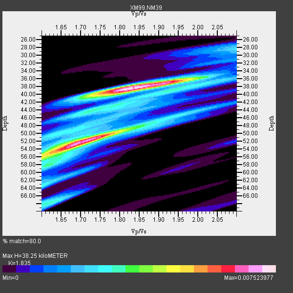
| Thickness Estimate: | 38 km |
| Thickness StdDev: | 8.3 km |
| Vp/Vs Estimate: | 1.84 |
| Vp/Vs StdDev: | 0.10 |
| Vs Estimate: | 3.54 km/s |
| Poisson's Ratio: | 0.29 |
| Peak Value: | 0.01 |
| Assumed Vp: | 6.496 km/s |
| Ps Weight: | 0.33333334 |
| PpPs Weight: | 0.33333334 |
| PsPs Weight: | 0.33333328 |
| Residual Complexity: | 0.773 |
| Nearby stations H: | +- |
| (2.0 deg) Vp/Vs: | +- |
9 with match > 90% ( 42.857143 %) and 20 with match > 80% ( 95.2381 %) out of 21.
Download stack as xyz text file.
Azimuth Distribution of Events:
Prior Results for this Station
| Study | Thickness | Vp/Vs | Vp | Vs | Poissons Ratio | Extra |
| EARS | 38 km | 1.84 | 6.496 km/s | 3.54 km/s | 0.29 | |
| Crust2.0 | 38 km | 1.78 | 6.496 km/s | 3.647 km/s | 0.27 | H7,early/mid Proter. shield, Austr., 1.5 km seds. |
| Wilson | 47 km | 1.76 | 6.22 km/s | 3.534 km/s | 0.26 | |
| Global Maxima | 38 km | 1.84 | 6.496 km/s | 3.54 km/s | 0.29 | amp=0.007523977 |
| Local Maxima 1 | 52 km | 1.69 | 6.496 km/s | 3.844 km/s | 0.23 | amp=0.006978172 |
| Local Maxima 2 | 56 km | 1.60 | 6.496 km/s | 4.054 km/s | 0.18 | amp=0.0036377935 |
| Local Maxima 3 | 50 km | 1.79 | 6.496 km/s | 3.624 km/s | 0.27 | amp=0.0034209061 |
| Local Maxima 4 | 68 km | 1.62 | 6.496 km/s | 4.022 km/s | 0.19 | amp=0.0032205074 |
| Predicted Arrivals for vertical incidence (zero ray parameter) | |
| Ps | 4.92 SECOND |
| PpPs | 16.69 SECOND |
| PsPs/PpSs | 21.61 SECOND |
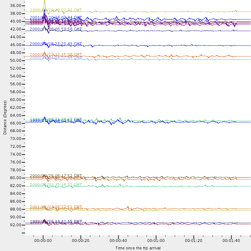
Events Processed for this Station
Download zip of receiver functions as SAC
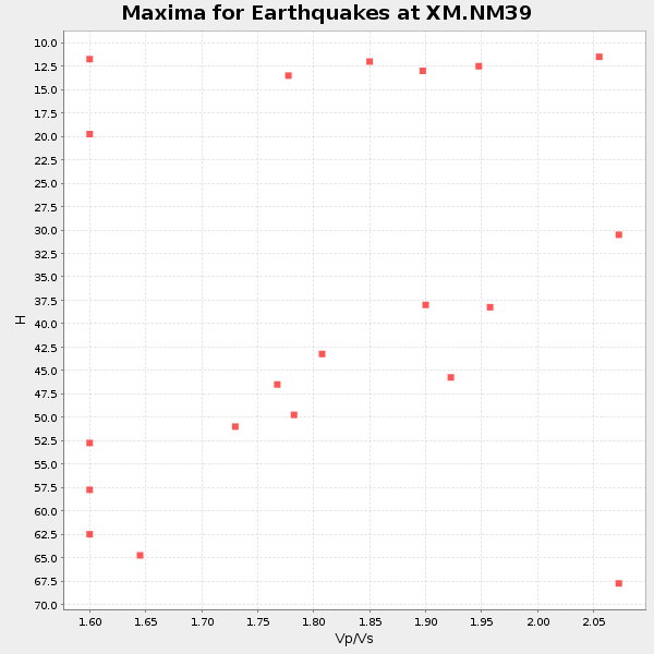
Plot maxima for each earthquake.
Events Used in the Stack
(20 events)| Radial Match | Distance | Baz | FERegion | Time | Lat/Lon | Depth | Magnitude |
| 96.58184 | 90.7 deg | 298.286 deg | Volcano Islands, Japan Region | 2000/03/28 11:00:22 GMT | (22.3, 143.7) | 126 km | 6.8 MB, 7.6 MS, 7.6 MW, 7.6 MW |
| 96.502205 | 48.0 deg | 109.097 deg | Windward Islands | 2000/10/04 14:37:44 GMT | (11.1, -62.6) | 110 km | 5.6 MB, 5.4 MS, 6.1 MW, 5.9 MD |
| 95.494026 | 34.5 deg | 134.61 deg | Costa Rica | 1999/08/20 10:02:21 GMT | (9.0, -84.2) | 20 km | 6.1 MB, 6.9 MS, 7.0 MW, 6.1 ML |
| 93.14068 | 94.3 deg | 253.001 deg | Vanuatu Islands | 1999/11/26 13:21:15 GMT | (-16.4, 168.2) | 33 km | 6.4 MB, 7.3 MS, 7.5 MW, 7.3 MW |
| 92.480064 | 39.9 deg | 128.45 deg | Panama-Colombia Border Region | 2000/11/08 06:59:58 GMT | (7.0, -77.8) | 17 km | 6.0 MB, 6.4 MS, 6.5 MW, 6.2 ML |
| 91.43957 | 44.1 deg | 138.145 deg | Near Coast Of Ecuador | 2000/09/28 23:23:43 GMT | (-0.2, -80.6) | 23 km | 5.8 MB, 6.0 MS, 6.6 MW, 6.4 MW |
| 91.40835 | 37.4 deg | 320.001 deg | Kodiak Island Region, Alaska | 1999/12/06 23:12:33 GMT | (57.4, -154.5) | 66 km | 6.8 MB, 7.0 MW, 7.0 ML |
| 91.31987 | 81.4 deg | 241.747 deg | Tonga Islands | 2000/09/26 06:17:52 GMT | (-17.2, -173.9) | 56 km | 6.1 MB, 6.1 MS, 6.4 MW, 6.1 ME |
| 91.03133 | 81.9 deg | 154.84 deg | Off Coast Of Southern Chile | 1999/08/22 09:35:39 GMT | (-40.5, -74.8) | 33 km | 6.2 MB, 5.8 MS, 6.4 MW, 6.2 MW |
| 89.525024 | 94.7 deg | 30.582 deg | Turkey | 1999/08/17 00:01:39 GMT | (40.7, 29.9) | 17 km | 6.3 MB, 7.8 MS, 7.7 ME, 7.6 MW |
| 88.076675 | 37.8 deg | 135.537 deg | South Of Panama | 2000/12/12 05:26:45 GMT | (6.0, -82.7) | 10 km | 5.8 MB, 5.7 MS, 6.3 ME, 6.1 MW |
| 87.58513 | 37.7 deg | 126.857 deg | Panama | 2000/02/26 18:24:39 GMT | (9.4, -78.5) | 65 km | 5.8 MB, 5.4 MS, 6.2 MW, 6.1 MW |
| 86.21428 | 90.3 deg | 313.576 deg | Western Honshu, Japan | 2001/03/24 06:27:53 GMT | (34.1, 132.5) | 50 km | 6.4 MB, 6.5 MS, 6.8 MW, 6.4 ME |
| 85.45673 | 65.8 deg | 139.115 deg | Northern Chile | 1999/11/30 04:01:53 GMT | (-18.9, -69.2) | 128 km | 6.2 MB, 6.6 MW, 6.5 MW |
| 84.58166 | 37.4 deg | 319.914 deg | Kodiak Island Region, Alaska | 1999/12/07 00:19:49 GMT | (57.4, -154.5) | 41 km | 6.5 MB, 6.1 MS, 6.4 MW, 6.3 ML |
| 83.45643 | 47.1 deg | 141.585 deg | Near Coast Of Northern Peru | 2000/05/22 13:15:08 GMT | (-4.1, -81.1) | 33 km | 5.3 MB, 5.4 MS, 5.8 MW, 5.8 MW |
| 82.01274 | 36.7 deg | 319.772 deg | Kodiak Island Region, Alaska | 2001/01/10 16:02:44 GMT | (57.1, -153.2) | 33 km | 6.2 MB, 6.8 MS, 7.1 MW, 6.8 ML |
| 81.87117 | 84.0 deg | 239.248 deg | Tonga Islands | 2000/01/02 15:16:32 GMT | (-20.8, -174.2) | 33 km | 5.5 MB, 5.8 MS, 5.8 MW, 5.8 MW |
| 81.69085 | 38.2 deg | 135.865 deg | South Of Panama | 1999/12/28 12:46:58 GMT | (5.6, -82.6) | 10 km | 5.4 MB, 5.5 MS, 5.9 MW, 5.5 ML |
| 80.89164 | 65.5 deg | 316.393 deg | Near East Coast Of Kamchatka | 1999/09/18 21:28:33 GMT | (51.2, 157.6) | 60 km | 5.9 MB, 5.6 MS, 6.2 MW, 6.0 MW |
Losers
(1 events)| Radial Match | Distance | Baz | FERegion | Time | Lat/Lon | Depth | Magnitude | Reason |
| 86.60936 | 58.2 deg | 317.115 deg | Komandorskiye Ostrova Region | 1999/09/28 05:00:42 GMT | (54.6, 168.3) | 33 km | 5.4 MB, 6.1 MS, 6.1 MW, 6.1 MW |
