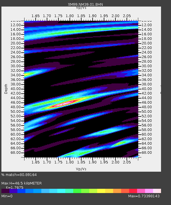
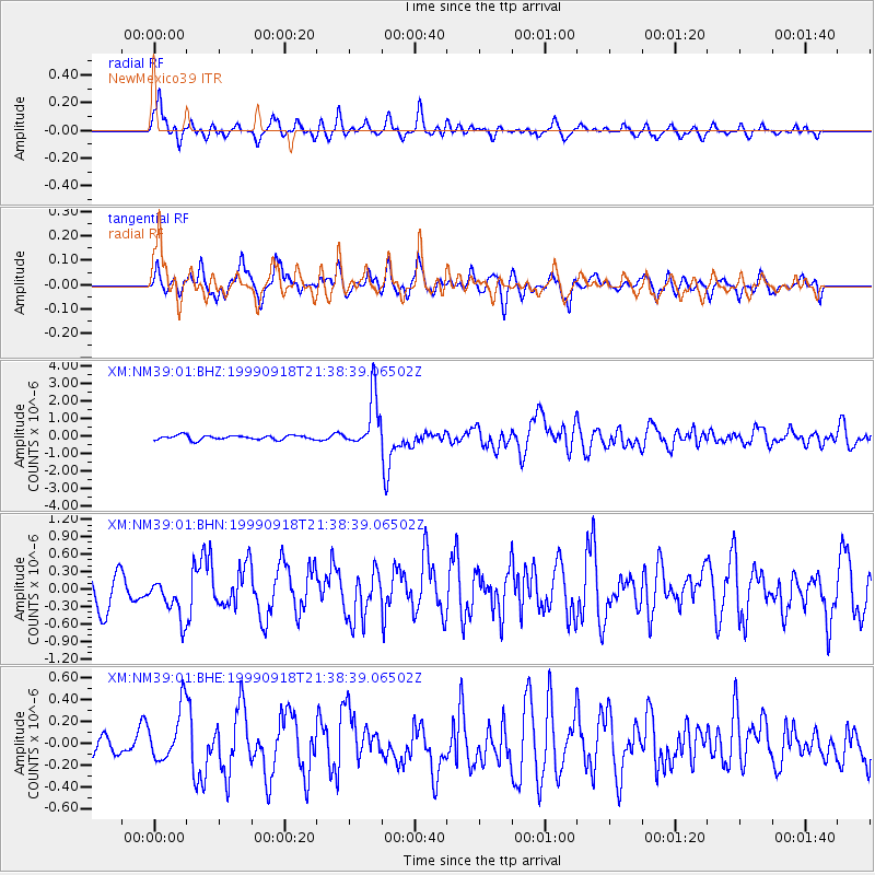
NM39 NewMexico39 - Earthquake Result Viewer

Earthquake location: Near East Coast Of Kamchatka
Earthquake latitude/longitude: 51.2/157.6
Earthquake time(UTC): 1999/09/18 (261) 21:28:33 GMT
Earthquake Depth: 60 km
Earthquake Magnitude: 5.9 MB, 5.6 MS, 6.2 MW, 6.0 MW
Earthquake Catalog/Contributor: WHDF/NEIC
Network: XM Rio Grande Seismic Transect
Station: NM39 NewMexico39
Lat/Lon: 35.79 N/108.27 W
Elevation: 1949 m
Distance: 65.5 deg
Az: 63.047 deg
Baz: 316.393 deg
Ray Param: 0.05812238
Estimated Moho Depth: 46.5 km
Estimated Crust Vp/Vs: 1.77
Assumed Crust Vp: 6.496 km/s
Estimated Crust Vs: 3.675 km/s
Estimated Crust Poisson's Ratio: 0.26
Radial Match: 80.89164 %
Radial Bump: 400
Transverse Match: 62.674606 %
Transverse Bump: 400
SOD ConfigId: 27569
Insert Time: 2010-02-26 17:38:16.657 +0000
GWidth: 2.5
Max Bumps: 400
Tol: 0.001

Signal To Noise

ChannelStoNSTALTA
XM:NM39:01:BHN:19990918T21:38:39.06502Z1.29652813.5493923E-72.7376132E-7
XM:NM39:01:BHE:19990918T21:38:39.06502Z1.90156382.403489E-71.2639539E-7
XM:NM39:01:BHZ:19990918T21:38:39.06502Z12.1055591.479608E-61.222255E-7
Arrivals
Ps5.7 SECOND
PpPs19 SECOND
PsPs/PpSs25 SECOND