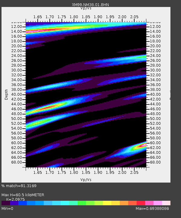
NM38 NewMexico38 - Earthquake Result Viewer
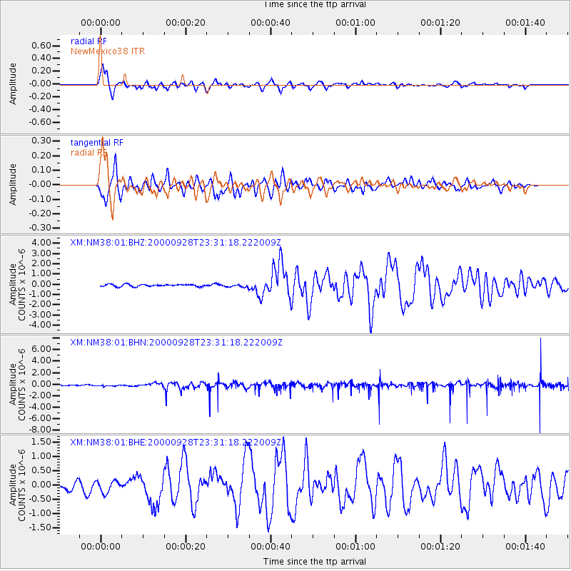
Earthquake location: Near Coast Of Ecuador
Earthquake latitude/longitude: -0.2/-80.6
Earthquake time(UTC): 2000/09/28 (272) 23:23:43 GMT
Earthquake Depth: 23 km
Earthquake Magnitude: 5.8 MB, 6.0 MS, 6.6 MW, 6.4 MW
Earthquake Catalog/Contributor: WHDF/NEIC
Network: XM Rio Grande Seismic Transect
Station: NM38 NewMexico38
Lat/Lon: 35.70 N/108.16 W
Elevation: 2077 m
Distance: 44.0 deg
Az: 327.152 deg
Baz: 138.209 deg
Ray Param: 0.07214715
Estimated Moho Depth: 60.5 km
Estimated Crust Vp/Vs: 2.10
Assumed Crust Vp: 6.496 km/s
Estimated Crust Vs: 3.097 km/s
Estimated Crust Poisson's Ratio: 0.35
Radial Match: 91.3169 %
Radial Bump: 400
Transverse Match: 84.75172 %
Transverse Bump: 400
SOD ConfigId: 27569
Insert Time: 2010-02-26 17:38:26.949 +0000
GWidth: 2.5
Max Bumps: 400
Tol: 0.001

Signal To Noise

ChannelStoNSTALTA
XM:NM38:01:BHN:20000928T23:31:18.222009Z0.40993371.156758E-72.8218173E-7
XM:NM38:01:BHE:20000928T23:31:18.222009Z1.16291382.0052505E-71.7243329E-7
XM:NM38:01:BHZ:20000928T23:31:18.222009Z1.25699851.2853485E-71.0225536E-7
Arrivals
Ps11 SECOND
PpPs27 SECOND
PsPs/PpSs38 SECOND