
Station XM NM38 - NewMexico38
Network: XM99 - Rio Grande Seismic Transect
Nearby stations (2 deg radius)
| Station | Name | (Lat, Lon) | Start / End | Elevation |
| NM38 | NewMexico38 | (35.70, -108.16) | 1999-07-28 / 2001-12-31 | 2077 m |
| Crust2 Type: | H7,early/mid Proter. shield, Austr., 1.5 km seds. |
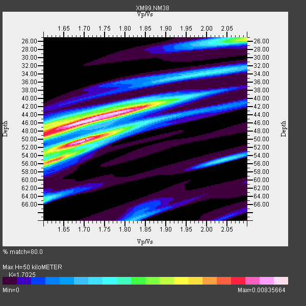
| Thickness Estimate: | 50 km |
| Thickness StdDev: | 5.1 km |
| Vp/Vs Estimate: | 1.70 |
| Vp/Vs StdDev: | 0.09 |
| Vs Estimate: | 3.816 km/s |
| Poisson's Ratio: | 0.24 |
| Peak Value: | 0.01 |
| Assumed Vp: | 6.496 km/s |
| Ps Weight: | 0.33333334 |
| PpPs Weight: | 0.33333334 |
| PsPs Weight: | 0.33333328 |
| Residual Complexity: | 0.803 |
| Nearby stations H: | +- |
| (2.0 deg) Vp/Vs: | +- |
8 with match > 90% ( 44.444443 %) and 17 with match > 80% ( 94.44444 %) out of 18.
Download stack as xyz text file.
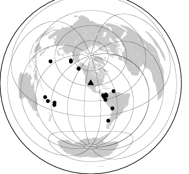
Azimuth Distribution of Events:
Prior Results for this Station
| Study | Thickness | Vp/Vs | Vp | Vs | Poissons Ratio | Extra |
| EARS | 50 km | 1.70 | 6.496 km/s | 3.816 km/s | 0.24 | |
| Crust2.0 | 38 km | 1.78 | 6.496 km/s | 3.647 km/s | 0.27 | H7,early/mid Proter. shield, Austr., 1.5 km seds. |
| Wilson | 47 km | 1.76 | 6.2 km/s | 3.523 km/s | 0.26 | |
| Global Maxima | 50 km | 1.70 | 6.496 km/s | 3.816 km/s | 0.24 | amp=0.00835664 |
| Local Maxima 1 | 46 km | 1.68 | 6.496 km/s | 3.878 km/s | 0.22 | amp=0.008070138 |
| Local Maxima 2 | 42 km | 1.84 | 6.496 km/s | 3.526 km/s | 0.29 | amp=0.005432719 |
| Local Maxima 3 | 25 km | 2.10 | 6.496 km/s | 3.097 km/s | 0.35 | amp=0.005209331 |
| Local Maxima 4 | 56 km | 1.60 | 6.496 km/s | 4.06 km/s | 0.18 | amp=0.0049689515 |
| Predicted Arrivals for vertical incidence (zero ray parameter) | |
| Ps | 5.41 SECOND |
| PpPs | 20.80 SECOND |
| PsPs/PpSs | 26.21 SECOND |
Events Processed for this Station
Download zip of receiver functions as SAC
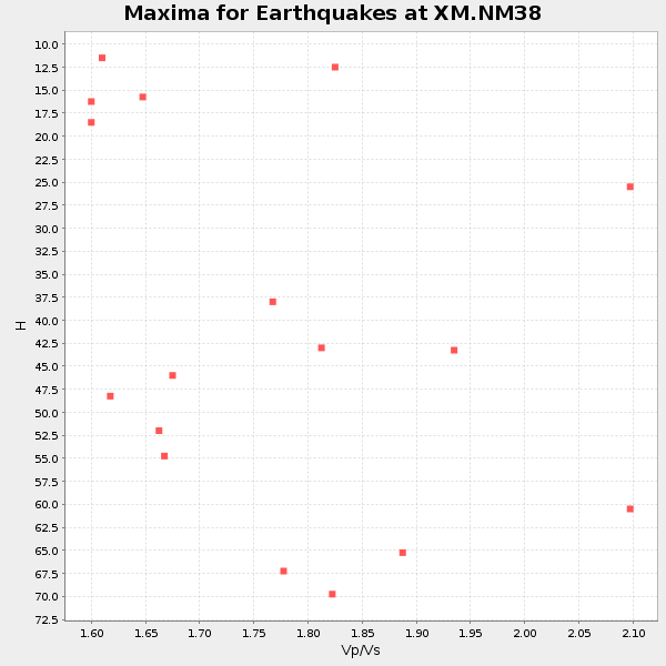
Plot maxima for each earthquake.
Events Used in the Stack
(17 events)| Radial Match | Distance | Baz | FERegion | Time | Lat/Lon | Depth | Magnitude |
| 97.74022 | 47.9 deg | 109.106 deg | Windward Islands | 2000/10/04 14:37:44 GMT | (11.1, -62.6) | 110 km | 5.6 MB, 5.4 MS, 6.1 MW, 5.9 MD |
| 95.203354 | 90.8 deg | 298.346 deg | Volcano Islands, Japan Region | 2000/03/28 11:00:22 GMT | (22.3, 143.7) | 126 km | 6.8 MB, 7.6 MS, 7.6 MW, 7.6 MW |
| 94.73843 | 81.4 deg | 241.826 deg | Tonga Islands | 2000/09/26 06:17:52 GMT | (-17.2, -173.9) | 56 km | 6.1 MB, 6.1 MS, 6.4 MW, 6.1 ME |
| 93.71201 | 34.4 deg | 134.664 deg | Costa Rica | 1999/08/20 10:02:21 GMT | (9.0, -84.2) | 20 km | 6.1 MB, 6.9 MS, 7.0 MW, 6.1 ML |
| 93.61394 | 94.4 deg | 253.053 deg | Vanuatu Islands | 1999/11/26 13:21:15 GMT | (-16.4, 168.2) | 33 km | 6.4 MB, 7.3 MS, 7.5 MW, 7.3 MW |
| 92.38186 | 81.8 deg | 154.906 deg | Off Coast Of Southern Chile | 1999/08/22 09:35:39 GMT | (-40.5, -74.8) | 33 km | 6.2 MB, 5.8 MS, 6.4 MW, 6.2 MW |
| 91.3169 | 44.0 deg | 138.209 deg | Near Coast Of Ecuador | 2000/09/28 23:23:43 GMT | (-0.2, -80.6) | 23 km | 5.8 MB, 6.0 MS, 6.6 MW, 6.4 MW |
| 90.283806 | 37.6 deg | 320.053 deg | Kodiak Island Region, Alaska | 1999/12/06 23:12:33 GMT | (57.4, -154.5) | 66 km | 6.8 MB, 7.0 MW, 7.0 ML |
| 89.52574 | 39.8 deg | 128.49 deg | Panama-Colombia Border Region | 2000/11/08 06:59:58 GMT | (7.0, -77.8) | 17 km | 6.0 MB, 6.4 MS, 6.5 MW, 6.2 ML |
| 85.27028 | 37.6 deg | 126.89 deg | Panama | 2000/02/26 18:24:39 GMT | (9.4, -78.5) | 65 km | 5.8 MB, 5.4 MS, 6.2 MW, 6.1 MW |
| 84.63044 | 38.1 deg | 135.924 deg | South Of Panama | 1999/12/28 12:46:58 GMT | (5.6, -82.6) | 10 km | 5.4 MB, 5.5 MS, 5.9 MW, 5.5 ML |
| 83.08846 | 84.0 deg | 239.321 deg | Tonga Islands | 2000/01/02 15:16:32 GMT | (-20.8, -174.2) | 33 km | 5.5 MB, 5.8 MS, 5.8 MW, 5.8 MW |
| 82.5606 | 91.9 deg | 247.393 deg | Vanuatu Islands Region | 2000/02/25 01:43:58 GMT | (-19.5, 173.8) | 33 km | 6.1 MB, 7.1 MS, 7.1 MW, 7.0 MW |
| 82.170815 | 58.3 deg | 317.175 deg | Komandorskiye Ostrova Region | 1999/09/28 05:00:42 GMT | (54.6, 168.3) | 33 km | 5.4 MB, 6.1 MS, 6.1 MW, 6.1 MW |
| 82.04345 | 65.7 deg | 139.178 deg | Northern Chile | 1999/11/30 04:01:53 GMT | (-18.9, -69.2) | 128 km | 6.2 MB, 6.6 MW, 6.5 MW |
| 81.33789 | 37.6 deg | 319.966 deg | Kodiak Island Region, Alaska | 1999/12/07 00:19:49 GMT | (57.4, -154.5) | 41 km | 6.5 MB, 6.1 MS, 6.4 MW, 6.3 ML |
| 80.391014 | 59.7 deg | 318.41 deg | Komandorskiye Ostrova Region | 1999/11/26 00:29:00 GMT | (55.1, 165.4) | 33 km | 5.6 MB, 5.8 MS |
Losers
(1 events)| Radial Match | Distance | Baz | FERegion | Time | Lat/Lon | Depth | Magnitude | Reason |
| 87.38407 | 80.4 deg | 242.658 deg | Tonga Islands | 2000/09/11 17:17:53 GMT | (-15.9, -173.7) | 115 km | 6.0 MB, 6.3 MW, 6.3 MW |
