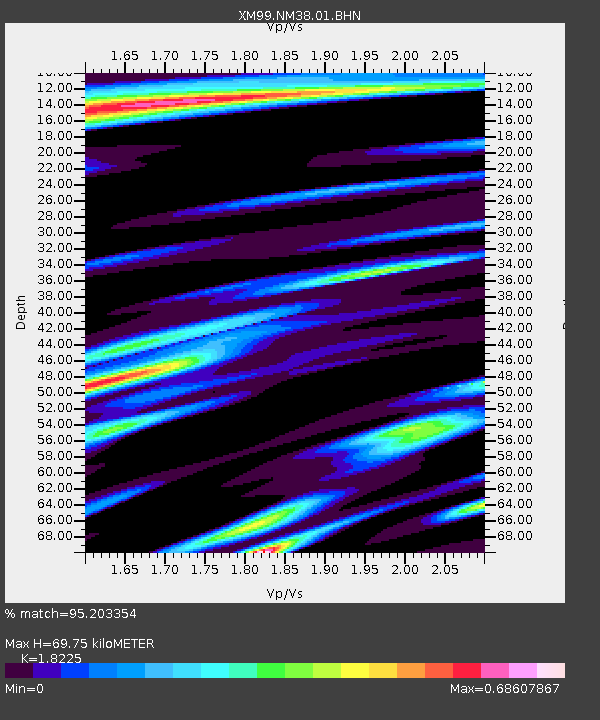
NM38 NewMexico38 - Earthquake Result Viewer
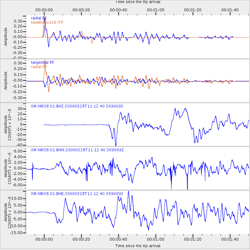
Earthquake location: Volcano Islands, Japan Region
Earthquake latitude/longitude: 22.3/143.7
Earthquake time(UTC): 2000/03/28 (088) 11:00:22 GMT
Earthquake Depth: 126 km
Earthquake Magnitude: 6.8 MB, 7.6 MS, 7.6 MW, 7.6 MW
Earthquake Catalog/Contributor: WHDF/NEIC
Network: XM Rio Grande Seismic Transect
Station: NM38 NewMexico38
Lat/Lon: 35.70 N/108.16 W
Elevation: 2077 m
Distance: 90.8 deg
Az: 50.686 deg
Baz: 298.346 deg
Ray Param: 0.04161897
Estimated Moho Depth: 69.75 km
Estimated Crust Vp/Vs: 1.82
Assumed Crust Vp: 6.496 km/s
Estimated Crust Vs: 3.564 km/s
Estimated Crust Poisson's Ratio: 0.28
Radial Match: 95.203354 %
Radial Bump: 400
Transverse Match: 87.91596 %
Transverse Bump: 400
SOD ConfigId: 27569
Insert Time: 2010-02-26 17:38:28.311 +0000
GWidth: 2.5
Max Bumps: 400
Tol: 0.001

Signal To Noise

ChannelStoNSTALTA
XM:NM38:01:BHN:20000328T11:12:40.369009Z0.459617231.4454389E-73.1448752E-7
XM:NM38:01:BHE:20000328T11:12:40.369009Z1.78834583.6235258E-72.0261885E-7
XM:NM38:01:BHZ:20000328T11:12:40.369009Z2.08587245.4789245E-72.6266824E-7
Arrivals
Ps9.0 SECOND
PpPs30 SECOND
PsPs/PpSs39 SECOND