You are here: Home > Network List > XM99 - Rio Grande Seismic Transect Stations List
> Station NM38 NewMexico38 > Earthquake Result Viewer
NM38 NewMexico38 - Earthquake Result Viewer
| Earthquake location: |
Komandorskiye Ostrova Region |
| Earthquake latitude/longitude: |
55.1/165.4 |
| Earthquake time(UTC): |
1999/11/26 (330) 00:29:00 GMT |
| Earthquake Depth: |
33 km |
| Earthquake Magnitude: |
5.6 MB, 5.8 MS |
| Earthquake Catalog/Contributor: |
WHDF/NEIC |
|
| Network: |
XM Rio Grande Seismic Transect |
| Station: |
NM38 NewMexico38 |
| Lat/Lon: |
35.70 N/108.16 W |
| Elevation: |
2077 m |
|
| Distance: |
59.7 deg |
| Az: |
70.189 deg |
| Baz: |
318.41 deg |
| Ray Param: |
0.061953515 |
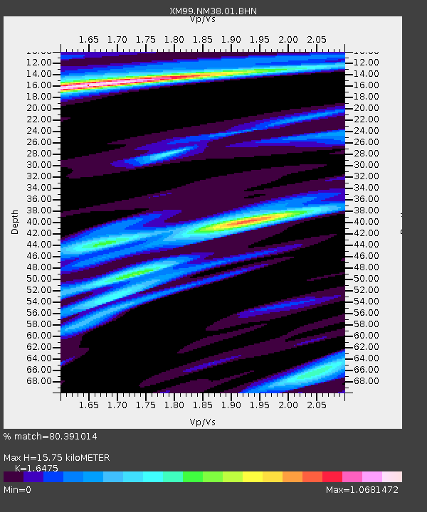
| Estimated Moho Depth: |
15.75 km |
| Estimated Crust Vp/Vs: |
1.65 |
| Assumed Crust Vp: |
6.496 km/s |
| Estimated Crust Vs: |
3.943 km/s |
| Estimated Crust Poisson's Ratio: |
0.21 |
|
| Radial Match: |
80.391014 % |
| Radial Bump: |
382 |
| Transverse Match: |
79.02793 % |
| Transverse Bump: |
400 |
| SOD ConfigId: |
27569 |
| Insert Time: |
2010-02-26 17:38:48.179 +0000 |
| GWidth: |
2.5 |
| Max Bumps: |
400 |
| Tol: |
0.001 |
|
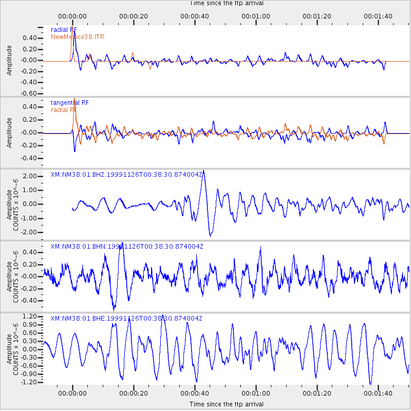
Signal To Noise
| Channel | StoN | STA | LTA |
| XM:NM38:01:BHN:19991126T00:38:30.874004Z | 0.87449443 | 1.08964535E-7 | 1.2460289E-7 |
| XM:NM38:01:BHE:19991126T00:38:30.874004Z | 1.8844829 | 3.9465846E-7 | 2.0942534E-7 |
| XM:NM38:01:BHZ:19991126T00:38:30.874004Z | 0.6805379 | 1.7228353E-7 | 2.5315788E-7 |
| Arrivals |
| Ps | 1.7 SECOND |
| PpPs | 6.1 SECOND |
| PsPs/PpSs | 7.7 SECOND |


