You are here: Home > Network List > XM99 - Rio Grande Seismic Transect Stations List
> Station NM38 NewMexico38 > Earthquake Result Viewer
NM38 NewMexico38 - Earthquake Result Viewer
| Earthquake location: |
Kodiak Island Region, Alaska |
| Earthquake latitude/longitude: |
57.4/-154.5 |
| Earthquake time(UTC): |
1999/12/06 (340) 23:12:33 GMT |
| Earthquake Depth: |
66 km |
| Earthquake Magnitude: |
6.8 MB, 7.0 MW, 7.0 ML |
| Earthquake Catalog/Contributor: |
WHDF/NEIC |
|
| Network: |
XM Rio Grande Seismic Transect |
| Station: |
NM38 NewMexico38 |
| Lat/Lon: |
35.70 N/108.16 W |
| Elevation: |
2077 m |
|
| Distance: |
37.6 deg |
| Az: |
105.046 deg |
| Baz: |
320.053 deg |
| Ray Param: |
0.0758731 |
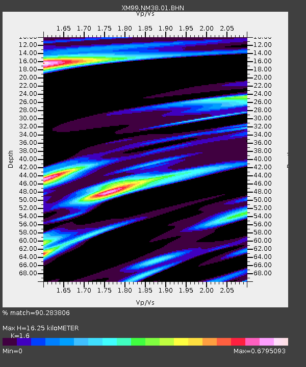
| Estimated Moho Depth: |
16.25 km |
| Estimated Crust Vp/Vs: |
1.60 |
| Assumed Crust Vp: |
6.496 km/s |
| Estimated Crust Vs: |
4.06 km/s |
| Estimated Crust Poisson's Ratio: |
0.18 |
|
| Radial Match: |
90.283806 % |
| Radial Bump: |
302 |
| Transverse Match: |
82.450676 % |
| Transverse Bump: |
400 |
| SOD ConfigId: |
27569 |
| Insert Time: |
2010-02-26 17:38:51.524 +0000 |
| GWidth: |
2.5 |
| Max Bumps: |
400 |
| Tol: |
0.001 |
|

Signal To Noise
| Channel | StoN | STA | LTA |
| XM:NM38:01:BHN:19991206T23:19:11.473986Z | 8.152623 | 1.597343E-6 | 1.9592997E-7 |
| XM:NM38:01:BHE:19991206T23:19:11.473986Z | 3.6904533 | 1.2415339E-6 | 3.364177E-7 |
| XM:NM38:01:BHZ:19991206T23:19:11.473986Z | 7.9474645 | 3.2111682E-6 | 4.040494E-7 |
| Arrivals |
| Ps | 1.6 SECOND |
| PpPs | 6.0 SECOND |
| PsPs/PpSs | 7.6 SECOND |


