You are here: Home > Network List > XI95 - Saudi Arabia Broadband Array Stations List
> Station TAIF XI.TAIF > Earthquake Result Viewer
TAIF XI.TAIF - Earthquake Result Viewer
| Earthquake location: |
Flores Sea |
| Earthquake latitude/longitude: |
-7.1/122.6 |
| Earthquake time(UTC): |
1996/06/17 (169) 11:22:18 GMT |
| Earthquake Depth: |
587 km |
| Earthquake Magnitude: |
6.6 MB, 7.9 UNKNOWN, 7.8 MW |
| Earthquake Catalog/Contributor: |
WHDF/NEIC |
|
| Network: |
XI Saudi Arabia Broadband Array |
| Station: |
TAIF XI.TAIF |
| Lat/Lon: |
21.28 N/40.35 E |
| Elevation: |
2050 m |
|
| Distance: |
85.4 deg |
| Az: |
292.014 deg |
| Baz: |
99.438 deg |
| Ray Param: |
0.04310155 |
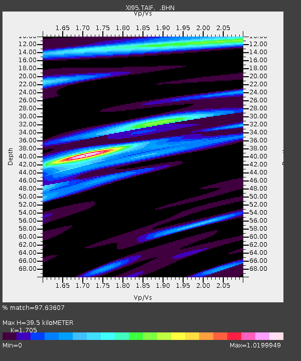
| Estimated Moho Depth: |
39.5 km |
| Estimated Crust Vp/Vs: |
1.71 |
| Assumed Crust Vp: |
6.65 km/s |
| Estimated Crust Vs: |
3.9 km/s |
| Estimated Crust Poisson's Ratio: |
0.24 |
|
| Radial Match: |
97.63607 % |
| Radial Bump: |
360 |
| Transverse Match: |
96.15453 % |
| Transverse Bump: |
400 |
| SOD ConfigId: |
6273 |
| Insert Time: |
2010-03-09 23:43:47.376 +0000 |
| GWidth: |
2.5 |
| Max Bumps: |
400 |
| Tol: |
0.001 |
|

Signal To Noise
| Channel | StoN | STA | LTA |
| XI:TAIF: :BHN:19960617T11:33:23.414001Z | 1.3450243 | 1.1110256E-7 | 8.260264E-8 |
| XI:TAIF: :BHE:19960617T11:33:23.414001Z | 5.2092414 | 3.2573234E-7 | 6.252971E-8 |
| XI:TAIF: :BHZ:19960617T11:33:23.414001Z | 14.214182 | 8.6559265E-7 | 6.089641E-8 |
| Arrivals |
| Ps | 4.3 SECOND |
| PpPs | 16 SECOND |
| PsPs/PpSs | 20 SECOND |


