
Station XI TAIF - XI.TAIF
Network: XI95 - Saudi Arabia Broadband Array
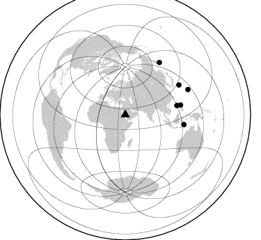
Nearby stations (2 deg radius)
| Station | Name | (Lat, Lon) | Start / End | Elevation |
| TAIF | XI.TAIF | (21.28, 40.35) | 1996-05-29 / 1997-03-02 | 2050 m |
| Crust2 Type: | IE,late Proter., no seds. |
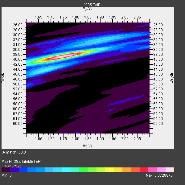
| Thickness Estimate: | 38 km |
| Thickness StdDev: | 0.5 km |
| Vp/Vs Estimate: | 1.75 |
| Vp/Vs StdDev: | 0.03 |
| Vs Estimate: | 3.795 km/s |
| Poisson's Ratio: | 0.26 |
| Peak Value: | 0.07 |
| Assumed Vp: | 6.65 km/s |
| Ps Weight: | 0.33333334 |
| PpPs Weight: | 0.33333334 |
| PsPs Weight: | 0.33333328 |
| Residual Complexity: | 0.370 |
| Nearby stations H: | +- |
| (2.0 deg) Vp/Vs: | +- |
4 with match > 90% ( 21.052631 %) and 6 with match > 80% ( 31.578947 %) out of 19.
Download stack as xyz text file.
Azimuth Distribution of Events:
Prior Results for this Station
| Study | Thickness | Vp/Vs | Vp | Vs | Poissons Ratio | Extra |
| EARS | 38 km | 1.75 | 6.65 km/s | 3.795 km/s | 0.26 | |
| Crust2.0 | 36 km | 1.77 | 6.65 km/s | 3.758 km/s | 0.27 | IE,late Proter., no seds. |
| Global Maxima | 38 km | 1.75 | 6.65 km/s | 3.795 km/s | 0.26 | amp=0.0728876 |
| Local Maxima 1 | 31 km | 1.95 | 6.65 km/s | 3.406 km/s | 0.32 | amp=0.020446815 |
| Local Maxima 2 | 42 km | 1.61 | 6.65 km/s | 4.13 km/s | 0.19 | amp=0.015986912 |
| Local Maxima 3 | 43 km | 1.72 | 6.65 km/s | 3.872 km/s | 0.24 | amp=0.013358914 |
| Local Maxima 4 | 32 km | 2.10 | 6.65 km/s | 3.17 km/s | 0.35 | amp=0.011824358 |
| Predicted Arrivals for vertical incidence (zero ray parameter) | |
| Ps | 4.36 SECOND |
| PpPs | 15.94 SECOND |
| PsPs/PpSs | 20.29 SECOND |
Events Processed for this Station
Download zip of receiver functions as SAC
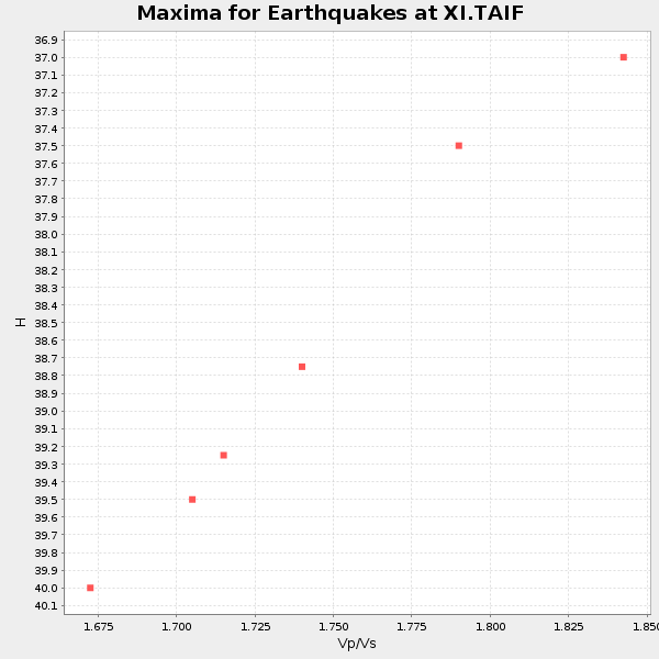
Plot maxima for each earthquake.
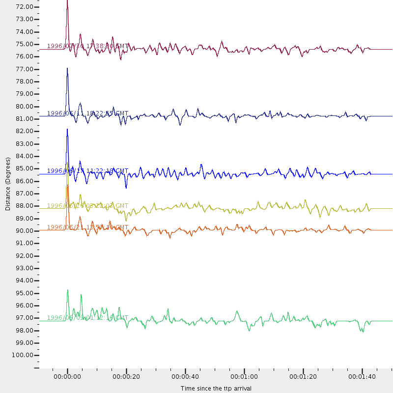
Events Used in the Stack
(6 events)| Radial Match | Distance | Baz | FERegion | Time | Lat/Lon | Depth | Magnitude |
| 97.63607 | 85.4 deg | 99.438 deg | Flores Sea | 1996/06/17 11:22:18 GMT | (-7.1, 122.6) | 587 km | 6.6 MB, 7.9 UNKNOWN, 7.8 MW |
| 96.57614 | 80.8 deg | 80.054 deg | Samar, Philippines | 1996/06/11 18:22:55 GMT | (12.6, 125.2) | 33 km | 6.0 MB, 7.0 MS, 7.2 UNKNOWN, 7.1 MW |
| 94.98899 | 89.9 deg | 33.168 deg | Off East Coast Of Kamchatka | 1996/06/21 13:57:10 GMT | (51.6, 159.1) | 20 km | 6.0 MB, 6.6 MS, 7.0 UNKNOWN, 6.5 MS |
| 94.39092 | 75.4 deg | 79.932 deg | Luzon, Philippines | 1996/07/30 17:38:30 GMT | (14.5, 120.0) | 33 km | 6.1 MB, 5.7 MS, 6.1 UNKNOWN, 5.9 MW |
| 83.72085 | 88.2 deg | 61.046 deg | Bonin Islands, Japan Region | 1996/06/26 03:22:03 GMT | (27.7, 139.7) | 469 km | 5.5 MB, 6.3 UNKNOWN, 5.4 MB |
| 81.55447 | 97.2 deg | 68.251 deg | Mariana Islands | 1996/06/09 01:12:16 GMT | (17.4, 145.5) | 149 km | 6.0 MB, 5.9 MS, 6.5 UNKNOWN, 6.5 MW |
Losers
(13 events)| Radial Match | Distance | Baz | FERegion | Time | Lat/Lon | Depth | Magnitude | Reason |
| 79.236694 | 90.1 deg | 33.264 deg | Off East Coast Of Kamchatka | 1996/06/22 14:50:07 GMT | (51.4, 159.2) | 33 km | 5.6 MB, 6.0 MS, 6.2 UNKNOWN, 6.2 MW | |
| 78.65851 | 90.2 deg | 32.789 deg | Off East Coast Of Kamchatka | 1996/06/30 11:32:35 GMT | (51.7, 159.8) | 33 km | 5.5 MB, 5.9 MS, 6.1 UNKNOWN, 6.0 MW | |
| 76.412315 | 81.4 deg | 80.481 deg | Samar, Philippines | 1996/08/08 23:12:35 GMT | (12.0, 125.7) | 33 km | 5.5 MS, 5.4 MB | |
| 69.78821 | 90.1 deg | 33.013 deg | Off East Coast Of Kamchatka | 1996/06/23 12:45:06 GMT | (51.6, 159.5) | 33 km | 5.3 MB, 6.1 MS | |
| 61.987534 | 96.8 deg | 67.018 deg | Mariana Islands | 1996/07/15 16:51:22 GMT | (18.7, 145.6) | 177 km | 5.9 MB, 6.3 UNKNOWN, 6.3 MW | |
| 61.324093 | 85.2 deg | 27.785 deg | Kamchatka Peninsula, Russia | 1996/07/07 10:49:59 GMT | (58.6, 157.8) | 10 km | 5.6 MB, 5.6 MS, 5.8 UNKNOWN, 5.8 MW | |
| 60.876076 | 70.6 deg | 15.11 deg | Laptev Sea | 1996/06/22 16:47:12 GMT | (75.8, 134.6) | 10 km | 5.6 MB, 5.5 MS, 5.8 UNKNOWN, 5.7 MW | |
| 45.301292 | 80.6 deg | 79.9 deg | Samar, Philippines | 1996/06/14 15:04:40 GMT | (12.8, 125.1) | 29 km | 5.6 MB, 5.8 MS, 6.1 UNKNOWN, 5.9 MW | |
| 39.05027 | 90.1 deg | 33.112 deg | Off East Coast Of Kamchatka | 1996/07/18 22:55:03 GMT | (51.5, 159.4) | 33 km | 5.5 MB, 5.2 MS | |
| 35.665066 | 97.3 deg | 78.003 deg | W. Caroline Islands, Micronesia | 1996/07/04 15:50:38 GMT | (8.5, 141.6) | 33 km | 5.1 MB, 5.4 MS, 6.0 UNKNOWN, 5.9 MW | |
| 32.474262 | 93.0 deg | 65.175 deg | Mariana Islands Region | 1996/07/06 21:36:28 GMT | (22.0, 142.8) | 241 km | 5.8 MB, 6.3 UNKNOWN, 6.2 MW | |
| 25.647816 | 45.3 deg | 51.972 deg | Southern Xinjiang, China | 1996/06/08 02:55:57 GMT | (41.7, 88.7) | 0.0 km | 5.9 MB, 4.3 MS | |
| 22.557787 | 72.7 deg | 149.302 deg | Mid-Indian Ridge | 1996/06/06 17:35:38 GMT | (-41.3, 80.7) | 20 km | 5.5 MB, 5.9 MS, 6.3 UNKNOWN, 6.2 MW |
