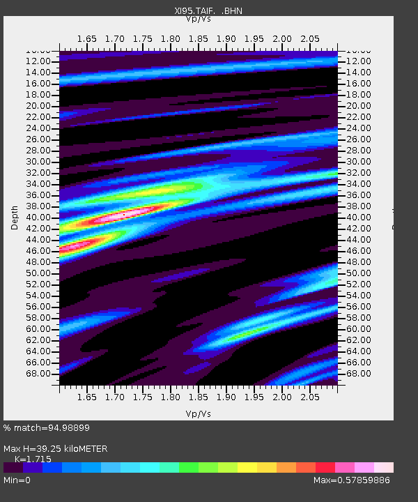
TAIF XI.TAIF - Earthquake Result Viewer

Earthquake location: Off East Coast Of Kamchatka
Earthquake latitude/longitude: 51.6/159.1
Earthquake time(UTC): 1996/06/21 (173) 13:57:10 GMT
Earthquake Depth: 20 km
Earthquake Magnitude: 6.0 MB, 6.6 MS, 7.0 UNKNOWN, 6.5 MS
Earthquake Catalog/Contributor: WHDF/NEIC
Network: XI Saudi Arabia Broadband Array
Station: TAIF XI.TAIF
Lat/Lon: 21.28 N/40.35 E
Elevation: 2050 m
Distance: 89.9 deg
Az: 305.164 deg
Baz: 33.168 deg
Ray Param: 0.04171019
Estimated Moho Depth: 39.25 km
Estimated Crust Vp/Vs: 1.72
Assumed Crust Vp: 6.65 km/s
Estimated Crust Vs: 3.878 km/s
Estimated Crust Poisson's Ratio: 0.24
Radial Match: 94.98899 %
Radial Bump: 360
Transverse Match: 86.64615 %
Transverse Bump: 400
SOD ConfigId: 6273
Insert Time: 2010-03-09 23:43:48.322 +0000
GWidth: 2.5
Max Bumps: 400
Tol: 0.001

Signal To Noise

ChannelStoNSTALTA
XI:TAIF: :BHN:19960621T14:09:36.018005Z2.97788122.7845869E-79.3508994E-8
XI:TAIF: :BHE:19960621T14:09:36.018005Z2.21316932.9748549E-71.3441606E-7
XI:TAIF: :BHZ:19960621T14:09:36.018005Z4.24901346.0324146E-71.4197212E-7
Arrivals
Ps4.3 SECOND
PpPs16 SECOND
PsPs/PpSs20 SECOND