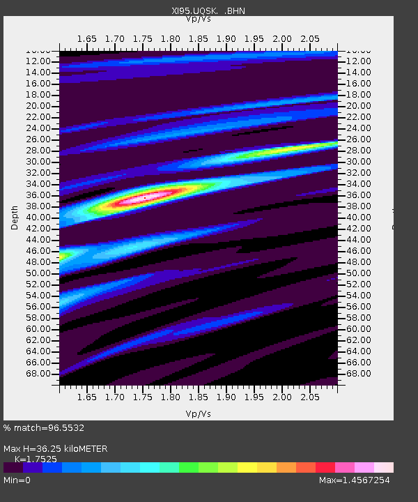
UQSK XI.UQSK - Earthquake Result Viewer
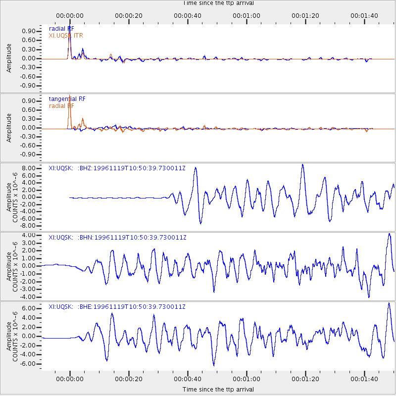
Earthquake location: Eastern Kashmir
Earthquake latitude/longitude: 35.3/78.1
Earthquake time(UTC): 1996/11/19 (324) 10:44:46 GMT
Earthquake Depth: 33 km
Earthquake Magnitude: 6.1 MB, 7.1 MS, 6.9 UNKNOWN, 6.8 MW
Earthquake Catalog/Contributor: WHDF/NEIC
Network: XI Saudi Arabia Broadband Array
Station: UQSK XI.UQSK
Lat/Lon: 25.79 N/42.36 E
Elevation: 950 m
Distance: 32.1 deg
Az: 262.699 deg
Baz: 64.085 deg
Ray Param: 0.07874787
Estimated Moho Depth: 36.25 km
Estimated Crust Vp/Vs: 1.75
Assumed Crust Vp: 6.642 km/s
Estimated Crust Vs: 3.79 km/s
Estimated Crust Poisson's Ratio: 0.26
Radial Match: 96.5532 %
Radial Bump: 217
Transverse Match: 59.74417 %
Transverse Bump: 400
SOD ConfigId: 6273
Insert Time: 2010-03-09 23:44:32.110 +0000
GWidth: 2.5
Max Bumps: 400
Tol: 0.001

Signal To Noise

ChannelStoNSTALTA
XI:UQSK: :BHN:19961119T10:50:39.730011Z0.993967062.3997202E-72.4142855E-7
XI:UQSK: :BHE:19961119T10:50:39.730011Z1.49332083.3938917E-72.2727143E-7
XI:UQSK: :BHZ:19961119T10:50:39.730011Z6.03897954.1858792E-76.9314346E-8
Arrivals
Ps4.5 SECOND
PpPs14 SECOND
PsPs/PpSs18 SECOND