
Station XI UQSK - XI.UQSK
Network: XI95 - Saudi Arabia Broadband Array
Nearby stations (2 deg radius)
| Station | Name | (Lat, Lon) | Start / End | Elevation |
| UQSK | XI.UQSK | (25.79, 42.36) | 1996-06-09 / 1997-03-02 | 950 m |
| Crust2 Type: | I1,late Proter., no seds. |
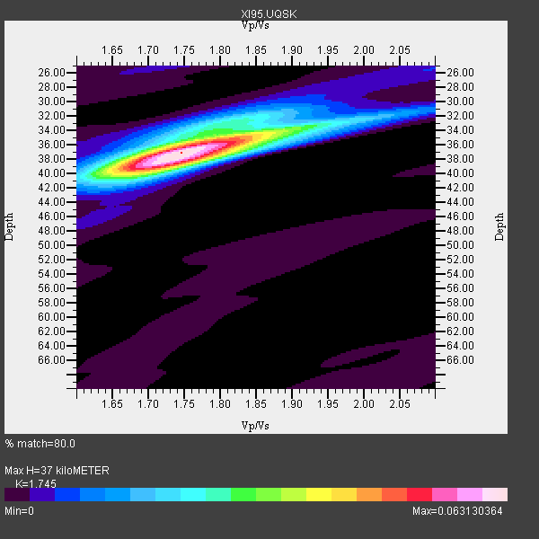
| Thickness Estimate: | 37 km |
| Thickness StdDev: | 0.7 km |
| Vp/Vs Estimate: | 1.75 |
| Vp/Vs StdDev: | 0.01 |
| Vs Estimate: | 3.806 km/s |
| Poisson's Ratio: | 0.26 |
| Peak Value: | 0.06 |
| Assumed Vp: | 6.642 km/s |
| Ps Weight: | 0.33333334 |
| PpPs Weight: | 0.33333334 |
| PsPs Weight: | 0.33333328 |
| Residual Complexity: | 0.463 |
| Nearby stations H: | +- |
| (2.0 deg) Vp/Vs: | +- |
10 with match > 90% ( 14.285714 %) and 20 with match > 80% ( 28.571428 %) out of 70.
Download stack as xyz text file.
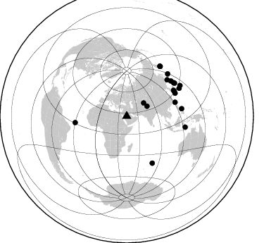
Azimuth Distribution of Events:
Prior Results for this Station
| Study | Thickness | Vp/Vs | Vp | Vs | Poissons Ratio | Extra |
| EARS | 37 km | 1.75 | 6.642 km/s | 3.806 km/s | 0.26 | |
| Crust2.0 | 43 km | 1.77 | 6.642 km/s | 3.756 km/s | 0.26 | I1,late Proter., no seds. |
| Global Maxima | 37 km | 1.75 | 6.642 km/s | 3.806 km/s | 0.26 | amp=0.063130364 |
| Local Maxima 1 | 39 km | 1.72 | 6.642 km/s | 3.862 km/s | 0.24 | amp=0.034717582 |
| Local Maxima 2 | 34 km | 1.83 | 6.642 km/s | 3.624 km/s | 0.29 | amp=0.02520263 |
| Local Maxima 3 | 32 km | 1.81 | 6.642 km/s | 3.675 km/s | 0.28 | amp=0.011809833 |
| Local Maxima 4 | 32 km | 1.99 | 6.642 km/s | 3.342 km/s | 0.33 | amp=0.007400882 |
| Predicted Arrivals for vertical incidence (zero ray parameter) | |
| Ps | 4.15 SECOND |
| PpPs | 15.29 SECOND |
| PsPs/PpSs | 19.44 SECOND |
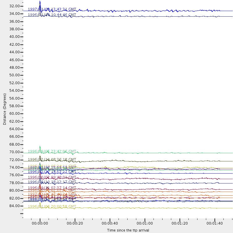
Events Processed for this Station
Download zip of receiver functions as SAC
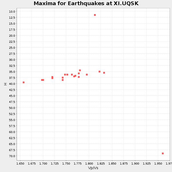
Plot maxima for each earthquake.
Events Used in the Stack
(20 events)| Radial Match | Distance | Baz | FERegion | Time | Lat/Lon | Depth | Magnitude |
| 98.92533 | 84.4 deg | 100.664 deg | Flores Sea | 1996/06/17 11:22:18 GMT | (-7.1, 122.6) | 587 km | 6.6 MB, 7.9 UNKNOWN, 7.8 MW |
| 98.02433 | 77.3 deg | 48.126 deg | Eastern Sea Of Japan | 1996/12/22 14:53:27 GMT | (43.2, 138.9) | 227 km | 6.0 MB, 6.5 UNKNOWN, 6.5 MW |
| 97.97513 | 85.1 deg | 34.009 deg | Off East Coast Of Kamchatka | 1996/06/21 13:57:10 GMT | (51.6, 159.1) | 20 km | 6.0 MB, 6.6 MS, 7.0 UNKNOWN, 6.5 MS |
| 97.88512 | 76.3 deg | 62.549 deg | Kyushu, Japan | 1996/10/18 10:50:20 GMT | (30.6, 131.1) | 10 km | 6.0 MB, 6.6 MS, 6.8 UNKNOWN, 6.8 MW |
| 97.50581 | 71.4 deg | 74.172 deg | Taiwan Region | 1996/09/05 23:42:06 GMT | (21.9, 121.5) | 20 km | 6.4 MB, 6.6 MS, 6.8 UNKNOWN, 6.8 ME |
| 96.86493 | 87.3 deg | 60.281 deg | Bonin Islands, Japan Region | 1996/11/06 20:00:58 GMT | (28.0, 143.5) | 9.0 km | 6.4 MB, 6.5 MS, 6.6 UNKNOWN, 6.4 ME |
| 96.5532 | 32.1 deg | 64.085 deg | Eastern Kashmir | 1996/11/19 10:44:46 GMT | (35.3, 78.1) | 33 km | 6.1 MB, 7.1 MS, 6.9 UNKNOWN, 6.8 MW |
| 96.03777 | 76.1 deg | 61.313 deg | Kyushu, Japan | 1996/12/02 22:17:59 GMT | (31.8, 131.3) | 49 km | 6.0 MB, 6.6 MS, 6.8 UNKNOWN, 6.3 ME |
| 94.627266 | 84.4 deg | 62.044 deg | Bonin Islands, Japan Region | 1996/06/26 03:22:03 GMT | (27.7, 139.7) | 469 km | 5.5 MB, 6.3 UNKNOWN, 5.4 MB |
| 93.76297 | 85.3 deg | 34.102 deg | Off East Coast Of Kamchatka | 1996/06/22 14:50:07 GMT | (51.4, 159.2) | 33 km | 5.6 MB, 6.0 MS, 6.2 UNKNOWN, 6.2 MW |
| 88.2341 | 30.5 deg | 52.082 deg | Kyrgyzstan | 1997/01/09 13:43:31 GMT | (41.0, 74.3) | 22 km | 5.7 MB, 5.8 MS, 5.7 UNKNOWN, 5.7 MW |
| 87.99832 | 82.6 deg | 55.549 deg | Off East Coast Of Honshu, Japan | 1996/11/20 02:27:47 GMT | (34.3, 141.1) | 33 km | 5.9 MB, 5.7 MS, 6.1 UNKNOWN, 6.1 MW |
| 86.98772 | 81.9 deg | 54.542 deg | Near East Coast Of Honshu, Japan | 1996/09/11 02:37:14 GMT | (35.5, 140.9) | 55 km | 6.1 MB, 5.7 MS, 6.2 UNKNOWN, 6.1 MW |
| 85.60701 | 85.4 deg | 33.624 deg | Off East Coast Of Kamchatka | 1996/06/30 11:32:35 GMT | (51.7, 159.8) | 33 km | 5.5 MB, 5.9 MS, 6.1 UNKNOWN, 6.0 MW |
| 85.18389 | 76.1 deg | 64.6 deg | Ryukyu Islands, Japan | 1997/01/17 15:53:13 GMT | (28.8, 130.0) | 33 km | 5.9 MB, 6.3 MS, 6.3 UNKNOWN, 6.2 MW |
| 84.771324 | 78.9 deg | 82.277 deg | Samar, Philippines | 1996/10/02 09:48:01 GMT | (11.8, 125.5) | 33 km | 6.0 MB, 6.4 MS, 6.4 UNKNOWN, 6.3 MW |
| 82.9759 | 80.2 deg | 51.609 deg | Eastern Honshu, Japan | 1996/08/10 18:12:17 GMT | (38.9, 140.5) | 10 km | 6.0 MB, 5.7 MS, 5.9 UNKNOWN, 5.9 MW |
| 82.726555 | 83.7 deg | 44.19 deg | East Of Kuril Islands | 1997/02/21 23:40:24 GMT | (43.8, 149.2) | 33 km | 6.1 MB, 5.6 MS, 6.1 UNKNOWN, 6.1 MW |
| 80.97029 | 73.8 deg | 262.988 deg | Central Mid-Atlantic Ridge | 1996/12/10 08:36:18 GMT | (0.9, -30.0) | 10 km | 6.0 MB, 6.2 MS, 6.6 UNKNOWN, 6.6 MW |
| 80.43191 | 75.7 deg | 151.464 deg | Mid-Indian Ridge | 1996/08/19 06:24:11 GMT | (-41.5, 80.4) | 10 km | 5.4 MB, 5.9 MS, 6.0 UNKNOWN, 5.9 MW |
Losers
(50 events)| Radial Match | Distance | Baz | FERegion | Time | Lat/Lon | Depth | Magnitude | Reason |
| 89.95405 | 80.2 deg | 51.575 deg | Eastern Honshu, Japan | 1996/08/10 18:54:11 GMT | (38.9, 140.6) | 10 km | 5.7 MB, 5.1 MS | |
| 79.13199 | 71.0 deg | 150.007 deg | Mid-Indian Ridge | 1996/08/27 10:50:49 GMT | (-36.9, 78.5) | 10 km | 5.8 MS, 5.3 MB, 5.9 UNKNOWN, 5.9 MW | |
| 78.95936 | 83.6 deg | 93.397 deg | Southern Molucca Sea | 1996/08/12 17:00:27 GMT | (-0.3, 125.1) | 42 km | 5.7 MB, 5.5 MS, 6.1 UNKNOWN, 6.0 MW | |
| 78.71654 | 95.7 deg | 23.408 deg | Andreanof Islands, Aleutian Is. | 1996/06/10 15:24:56 GMT | (51.5, -176.8) | 26 km | 5.9 MB, 7.1 MS, 7.2 UNKNOWN, 6.9 MS | |
| 77.94362 | 79.5 deg | 83.913 deg | Leyte, Philippines | 1996/09/28 14:10:42 GMT | (10.0, 125.4) | 235 km | 5.6 MB, 6.4 UNKNOWN, 6.3 MW | |
| 75.34262 | 89.5 deg | 65.901 deg | Mariana Islands Region | 1996/07/06 21:36:28 GMT | (22.0, 142.8) | 241 km | 5.8 MB, 6.3 UNKNOWN, 6.2 MW | |
| 72.15837 | 72.8 deg | 81.912 deg | Luzon, Philippines | 1996/07/30 17:38:30 GMT | (14.5, 120.0) | 33 km | 6.1 MB, 5.7 MS, 6.1 UNKNOWN, 5.9 MW | |
| 72.0396 | 93.3 deg | 67.514 deg | Mariana Islands | 1996/07/15 16:51:22 GMT | (18.7, 145.6) | 177 km | 5.9 MB, 6.3 UNKNOWN, 6.3 MW | |
| 67.76221 | 84.3 deg | 42.331 deg | Kuril Islands | 1996/10/02 11:24:48 GMT | (45.1, 151.2) | 33 km | 6.1 MB, 5.4 MS, 6.0 UNKNOWN, 6.0 MW | |
| 67.06261 | 81.8 deg | 87.632 deg | Mindanao, Philippines | 1996/10/17 16:15:25 GMT | (5.7, 125.9) | 117 km | 5.7 MB, 5.9 UNKNOWN, 5.9 MW | |
| 66.54619 | 80.5 deg | 84.06 deg | Mindanao, Philippines | 1996/09/20 04:10:27 GMT | (9.5, 126.3) | 33 km | 5.8 MB, 6.4 MS, 6.6 UNKNOWN, 6.6 MW | |
| 66.49596 | 73.8 deg | 295.617 deg | Northern Mid-Atlantic Ridge | 1996/12/09 11:28:48 GMT | (29.9, -42.9) | 10 km | 5.9 MB, 6.1 MS, 6.0 UNKNOWN, 5.9 MW | |
| 64.21659 | 96.1 deg | 23.218 deg | Andreanof Islands, Aleutian Is. | 1996/06/11 10:40:08 GMT | (51.3, -176.3) | 33 km | 5.6 MB, 5.6 MS, 6.0 UNKNOWN, 5.5 MS | |
| 58.273598 | 80.4 deg | 48.173 deg | Hokkaido, Japan Region | 1997/02/20 07:54:58 GMT | (41.9, 142.7) | 33 km | 5.4 MB, 5.5 MS, 6.0 UNKNOWN, 6.0 MW | |
| 57.04344 | 94.5 deg | 78.387 deg | W. Caroline Islands, Micronesia | 1996/07/04 15:50:38 GMT | (8.5, 141.6) | 33 km | 5.1 MB, 5.4 MS, 6.0 UNKNOWN, 5.9 MW | |
| 53.847706 | 57.7 deg | 103.013 deg | Northern Sumatra, Indonesia | 1996/10/10 15:21:04 GMT | (3.4, 97.9) | 33 km | 5.7 MB, 6.1 MS, 6.3 UNKNOWN, 6.2 MW | |
| 53.5555 | 80.5 deg | 83.77 deg | Mindanao, Philippines | 1996/11/04 13:21:15 GMT | (9.7, 126.4) | 33 km | 5.6 MB, 5.6 MS | |
| 52.4943 | 73.7 deg | 82.253 deg | Mindoro, Philippines | 1996/07/20 09:14:04 GMT | (13.9, 120.7) | 110 km | 5.5 MB, 5.9 UNKNOWN, 5.9 MW | |
| 51.50712 | 95.3 deg | 23.76 deg | Andreanof Islands, Aleutian Is. | 1996/06/10 04:03:35 GMT | (51.6, -177.6) | 33 km | 6.6 MB, 7.6 MS, 7.9 UNKNOWN, 7.4 MS | |
| 50.83822 | 80.5 deg | 83.933 deg | Mindanao, Philippines | 1996/09/20 00:03:18 GMT | (9.6, 126.3) | 33 km | 5.8 MB, 6.2 MS, 6.4 UNKNOWN, 6.4 MW | |
| 50.465477 | 83.5 deg | 199.127 deg | Southwest Of Africa | 1996/09/20 17:37:06 GMT | (-53.1, 9.7) | 10 km | 5.6 MB | |
| 50.45608 | 78.9 deg | 81.998 deg | Samar, Philippines | 1996/08/08 23:12:35 GMT | (12.0, 125.7) | 33 km | 5.5 MS, 5.4 MB | |
| 49.49275 | 80.8 deg | 83.812 deg | Mindanao, Philippines | 1996/09/20 19:24:57 GMT | (9.6, 126.6) | 33 km | 5.5 MB, 5.6 MS, 5.9 UNKNOWN, 5.8 MW | |
| 48.8765 | 78.0 deg | 81.479 deg | Samar, Philippines | 1996/06/14 15:04:40 GMT | (12.8, 125.1) | 29 km | 5.6 MB, 5.8 MS, 6.1 UNKNOWN, 5.9 MW | |
| 47.616642 | 81.0 deg | 35.169 deg | Northwest Of Kuril Islands | 1996/10/08 07:52:58 GMT | (52.9, 152.5) | 627 km | 5.6 UNKNOWN, 5.2 MB | |
| 43.577835 | 80.5 deg | 83.76 deg | Mindanao, Philippines | 1996/11/05 12:29:45 GMT | (9.8, 126.4) | 33 km | 5.7 MB, 5.5 MS, 5.9 UNKNOWN, 5.8 MW | |
| 43.41352 | 83.7 deg | 13.309 deg | Near N. Coast Of Eastern Siberia | 1996/10/24 19:31:53 GMT | (67.0, -173.2) | 20 km | 6.0 MB, 5.9 MS, 6.1 UNKNOWN, 5.8 ME | |
| 42.357895 | 72.1 deg | 76.072 deg | Philippine Islands Region | 1997/01/19 04:33:22 GMT | (20.0, 121.4) | 33 km | 5.7 MB, 5.4 MS, 5.9 UNKNOWN, 5.8 MW | |
| 40.968895 | 97.4 deg | 89.525 deg | Near North Coast Of Irian Jaya | 1996/06/29 14:08:25 GMT | (-2.8, 139.3) | 33 km | 5.7 MS, 5.2 MB, 5.7 UNKNOWN | |
| 39.41191 | 85.3 deg | 33.849 deg | Off East Coast Of Kamchatka | 1996/06/23 12:45:06 GMT | (51.6, 159.5) | 33 km | 5.3 MB, 6.1 MS | |
| 35.596775 | 85.3 deg | 33.949 deg | Off East Coast Of Kamchatka | 1996/07/18 22:55:03 GMT | (51.5, 159.4) | 33 km | 5.5 MB, 5.2 MS | |
| 35.419155 | 80.1 deg | 57.487 deg | Near S. Coast Of Honshu, Japan | 1996/10/18 16:44:47 GMT | (33.7, 137.4) | 338 km | 5.6 UNKNOWN, 5.4 MB, 5.6 MW | |
| 35.244137 | 81.8 deg | 86.543 deg | Mindanao, Philippines | 1996/11/21 07:43:38 GMT | (6.7, 126.5) | 53 km | 5.8 MB, 6.0 UNKNOWN, 5.9 MW | |
| 34.81401 | 81.5 deg | 94.123 deg | Minahassa Peninsula, Sulawesi | 1996/08/01 04:08:23 GMT | (-0.0, 122.9) | 149 km | 5.5 MB, 5.6 UNKNOWN, 5.5 MW | |
| 33.076828 | 80.5 deg | 83.798 deg | Mindanao, Philippines | 1996/09/25 09:26:45 GMT | (9.7, 126.4) | 33 km | 5.5 MB, 5.7 MS | |
| 31.068789 | 80.1 deg | 103.614 deg | Bali Sea | 1997/02/15 12:11:14 GMT | (-7.8, 117.4) | 274 km | 5.6 MB, 5.6 UNKNOWN, 5.6 MW | |
| 30.987965 | 80.4 deg | 28.646 deg | Kamchatka Peninsula, Russia | 1996/07/07 10:49:59 GMT | (58.6, 157.8) | 10 km | 5.6 MB, 5.6 MS, 5.8 UNKNOWN, 5.8 MW | |
| 30.378206 | 95.2 deg | 24.201 deg | Andreanof Islands, Aleutian Is. | 1996/08/19 04:19:16 GMT | (51.5, -178.4) | 33 km | 5.7 MB, 5.6 MS, 6.0 UNKNOWN, 5.7 ML | |
| 30.368328 | 82.8 deg | 104.291 deg | Sumba Region, Indonesia | 1997/02/10 19:25:26 GMT | (-9.6, 119.5) | 33 km | 5.6 MB, 5.6 MS, 5.9 UNKNOWN, 5.8 MW | |
| 28.151693 | 72.6 deg | 79.922 deg | Luzon, Philippines | 1996/11/20 17:58:04 GMT | (16.3, 120.5) | 33 km | 5.7 MB, 5.7 MS, 6.0 UNKNOWN, 5.9 MW | |
| 27.847404 | 95.2 deg | 24.141 deg | Andreanof Islands, Aleutian Is. | 1996/06/12 02:16:48 GMT | (51.4, -178.2) | 33 km | 5.5 MB, 5.3 MS, 5.7 UNKNOWN, 5.6 ML | |
| 26.808674 | 94.8 deg | 73.977 deg | South Of Mariana Islands | 1996/09/02 20:41:52 GMT | (12.3, 143.8) | 33 km | 5.7 MB, 5.7 MS, 5.9 UNKNOWN, 5.8 MW | |
| 25.674871 | 82.4 deg | 93.831 deg | Minahassa Peninsula, Sulawesi | 1997/01/01 22:32:32 GMT | (-0.1, 123.8) | 115 km | 5.9 MB, 5.8 UNKNOWN, 5.7 MW | |
| 22.661476 | 81.4 deg | 94.176 deg | Minahassa Peninsula, Sulawesi | 1996/09/14 02:53:24 GMT | (-0.0, 122.8) | 181 km | 5.5 MB | |
| 22.468279 | 95.5 deg | 289.631 deg | Leeward Islands | 1996/09/24 11:42:18 GMT | (15.2, -61.4) | 147 km | 6.0 MB, 5.9 UNKNOWN, 5.7 MW | |
| 20.126465 | 80.8 deg | 35.984 deg | Sea Of Okhotsk | 1996/08/30 21:13:41 GMT | (52.3, 151.5) | 580 km | 5.5 UNKNOWN, 5.1 MB, 5.4 MW | |
| 19.205877 | 96.9 deg | 89.158 deg | Irian Jaya, Indonesia | 1996/12/26 20:48:23 GMT | (-2.2, 138.9) | 33 km | 6.0 MB, 6.1 MS, 6.3 UNKNOWN, 6.1 MW | |
| 17.189056 | 81.2 deg | 82.818 deg | Philippine Islands Region | 1996/11/20 19:42:56 GMT | (10.3, 127.4) | 33 km | 5.6 MB, 5.3 MS, 5.8 UNKNOWN, 5.8 MW | |
| 16.590225 | 71.6 deg | 108.684 deg | Java, Indonesia | 1996/12/09 03:54:16 GMT | (-7.9, 107.5) | 51 km | 5.5 MB, 5.7 MS, 6.1 UNKNOWN, 5.9 MW | |
| 8.668857 | 65.8 deg | 15.673 deg | Laptev Sea | 1996/06/22 16:47:12 GMT | (75.8, 134.6) | 10 km | 5.6 MB, 5.5 MS, 5.8 UNKNOWN, 5.7 MW |
