You are here: Home > Network List > XI00 - Ethiopia/Kenya Broadband Seismic Experiment Stations List
> Station BAHI BAHIR DAR > Earthquake Result Viewer
BAHI BAHIR DAR - Earthquake Result Viewer
| Earthquake location: |
Seram, Indonesia |
| Earthquake latitude/longitude: |
-4.0/127.8 |
| Earthquake time(UTC): |
2001/03/19 (078) 05:56:57 GMT |
| Earthquake Depth: |
33 km |
| Earthquake Magnitude: |
5.8 MB |
| Earthquake Catalog/Contributor: |
WHDF/NEIC |
|
| Network: |
XI Ethiopia/Kenya Broadband Seismic Experiment |
| Station: |
BAHI BAHIR DAR |
| Lat/Lon: |
11.57 N/37.39 E |
| Elevation: |
1793 m |
|
| Distance: |
91.2 deg |
| Az: |
281.442 deg |
| Baz: |
93.803 deg |
| Ray Param: |
0.04161258 |
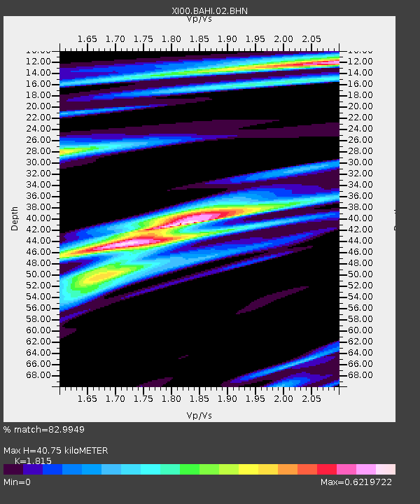
| Estimated Moho Depth: |
40.75 km |
| Estimated Crust Vp/Vs: |
1.82 |
| Assumed Crust Vp: |
6.464 km/s |
| Estimated Crust Vs: |
3.561 km/s |
| Estimated Crust Poisson's Ratio: |
0.28 |
|
| Radial Match: |
82.9949 % |
| Radial Bump: |
400 |
| Transverse Match: |
47.803368 % |
| Transverse Bump: |
400 |
| SOD ConfigId: |
16820 |
| Insert Time: |
2010-03-09 23:46:26.075 +0000 |
| GWidth: |
2.5 |
| Max Bumps: |
400 |
| Tol: |
0.001 |
|

Signal To Noise
| Channel | StoN | STA | LTA |
| XI:BAHI:02:BHN:20010319T06:09:27.610027Z | 1.2343118 | 2.7049143E-7 | 2.1914352E-7 |
| XI:BAHI:02:BHE:20010319T06:09:27.610027Z | 0.7461783 | 2.6961965E-7 | 3.613341E-7 |
| XI:BAHI:02:BHZ:20010319T06:09:27.610027Z | 0.6912559 | 4.542377E-7 | 6.571195E-7 |
| Arrivals |
| Ps | 5.2 SECOND |
| PpPs | 17 SECOND |
| PsPs/PpSs | 23 SECOND |


