
Station XI BAHI - BAHIR DAR
Network: XI00 - Ethiopia/Kenya Broadband Seismic Experiment
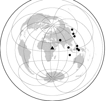
Nearby stations (2 deg radius)
| Station | Name | (Lat, Lon) | Start / End | Elevation |
| BAHI | BAHIR DAR | (11.57, 37.39) | 2001-03-12 / 2002-12-31 | 1793 m |
| Crust2 Type: | G9,thin custal Archean 0.1 km seds., South American |
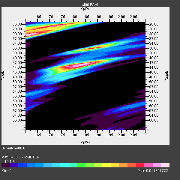
| Thickness Estimate: | 30 km |
| Thickness StdDev: | 7.9 km |
| Vp/Vs Estimate: | 1.60 |
| Vp/Vs StdDev: | 0.10 |
| Vs Estimate: | 4.04 km/s |
| Poisson's Ratio: | 0.18 |
| Peak Value: | 0.01 |
| Assumed Vp: | 6.464 km/s |
| Ps Weight: | 0.33333334 |
| PpPs Weight: | 0.33333334 |
| PsPs Weight: | 0.33333328 |
| Residual Complexity: | 0.886 |
| Nearby stations H: | +- |
| (2.0 deg) Vp/Vs: | +- |
2 with match > 90% ( 16.666666 %) and 12 with match > 80% ( 100.0 %) out of 12.
Download stack as xyz text file.
Azimuth Distribution of Events:
Prior Results for this Station
| Study | Thickness | Vp/Vs | Vp | Vs | Poissons Ratio | Extra |
| EARS | 30 km | 1.60 | 6.464 km/s | 4.04 km/s | 0.18 | |
| Crust2.0 | 31 km | 1.76 | 6.464 km/s | 3.663 km/s | 0.26 | G9,thin custal Archean 0.1 km seds., South American |
| Global Maxima | 30 km | 1.60 | 6.464 km/s | 4.04 km/s | 0.18 | amp=0.011747722 |
| Local Maxima 1 | 42 km | 1.84 | 6.464 km/s | 3.513 km/s | 0.29 | amp=0.011352325 |
| Local Maxima 2 | 26 km | 1.75 | 6.464 km/s | 3.704 km/s | 0.26 | amp=0.009853163 |
| Local Maxima 3 | 36 km | 1.88 | 6.464 km/s | 3.429 km/s | 0.30 | amp=0.009827401 |
| Local Maxima 4 | 45 km | 1.76 | 6.464 km/s | 3.662 km/s | 0.26 | amp=0.0057653002 |
| Predicted Arrivals for vertical incidence (zero ray parameter) | |
| Ps | 2.83 SECOND |
| PpPs | 12.27 SECOND |
| PsPs/PpSs | 15.10 SECOND |
Events Processed for this Station
Download zip of receiver functions as SAC
Plot maxima for each earthquake.
Events Used in the Stack
(12 events)| Radial Match | Distance | Baz | FERegion | Time | Lat/Lon | Depth | Magnitude |
| 95.70076 | 85.7 deg | 84.739 deg | Mindanao, Philippines | 2002/03/05 21:16:09 GMT | (6.0, 124.2) | 31 km | 6.3 MB, 7.2 MS, 7.5 MW, 7.2 MW |
| 93.341675 | 87.8 deg | 55.817 deg | Western Honshu, Japan | 2001/03/24 06:27:53 GMT | (34.1, 132.5) | 50 km | 6.4 MB, 6.5 MS, 6.8 MW, 6.4 ME |
| 89.37268 | 55.7 deg | 87.36 deg | Nicobar Islands, India Region | 2001/03/15 01:22:43 GMT | (8.7, 94.0) | 33 km | 5.6 MB, 5.9 MS, 6.0 MW, 6.0 MW |
| 88.23904 | 85.6 deg | 90.905 deg | Minahassa Peninsula, Sulawesi | 2001/12/09 18:15:02 GMT | (-0.0, 122.9) | 156 km | 5.7 MB, 6.2 MW, 6.0 MW |
| 88.12801 | 86.5 deg | 62.032 deg | Ryukyu Islands, Japan | 2001/12/08 20:29:34 GMT | (28.3, 129.6) | 33 km | 5.7 MB, 5.7 MS, 6.2 MW, 6.1 MW |
| 85.48765 | 91.4 deg | 93.798 deg | Banda Sea | 2001/03/19 05:52:15 GMT | (-4.0, 128.0) | 33 km | 6.0 MB, 6.5 MS, 6.5 MW, 6.5 MW |
| 85.46851 | 38.7 deg | 45.319 deg | Hindu Kush Region, Afghanistan | 2002/01/03 07:05:27 GMT | (36.1, 70.7) | 129 km | 5.8 MB, 6.2 MW, 6.1 MW |
| 84.847466 | 64.3 deg | 110.742 deg | South Indian Ocean | 2001/09/07 02:45:59 GMT | (-13.2, 97.3) | 10 km | 6.2 MB, 5.8 MS, 6.0 MW, 5.9 MW |
| 84.33098 | 93.5 deg | 47.072 deg | Hokkaido, Japan Region | 2001/08/13 20:11:23 GMT | (41.0, 142.3) | 38 km | 6.0 MB, 6.3 MS, 6.4 MW, 6.3 ME |
| 82.9949 | 91.2 deg | 93.803 deg | Seram, Indonesia | 2001/03/19 05:56:57 GMT | (-4.0, 127.8) | 33 km | 5.8 MB |
| 81.722435 | 38.7 deg | 44.687 deg | Hindu Kush Region, Afghanistan | 2002/03/03 12:08:07 GMT | (36.4, 70.4) | 209 km | 6.3 MB |
| 81.47119 | 38.8 deg | 44.617 deg | Hindu Kush Region, Afghanistan | 2002/03/03 12:08:19 GMT | (36.5, 70.5) | 226 km | 6.6 MB, 7.4 MW, 7.3 MW |
Losers
(0 events)| Radial Match | Distance | Baz | FERegion | Time | Lat/Lon | Depth | Magnitude | Reason |
