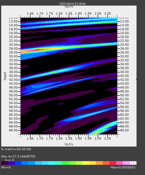
BAHI BAHIR DAR - Earthquake Result Viewer

Earthquake location: Banda Sea
Earthquake latitude/longitude: -4.0/128.0
Earthquake time(UTC): 2001/03/19 (078) 05:52:15 GMT
Earthquake Depth: 33 km
Earthquake Magnitude: 6.0 MB, 6.5 MS, 6.5 MW, 6.5 MW
Earthquake Catalog/Contributor: WHDF/NEIC
Network: XI Ethiopia/Kenya Broadband Seismic Experiment
Station: BAHI BAHIR DAR
Lat/Lon: 11.57 N/37.39 E
Elevation: 1793 m
Distance: 91.4 deg
Az: 281.43 deg
Baz: 93.798 deg
Ray Param: 0.041600093
Estimated Moho Depth: 27.5 km
Estimated Crust Vp/Vs: 1.60
Assumed Crust Vp: 6.464 km/s
Estimated Crust Vs: 4.04 km/s
Estimated Crust Poisson's Ratio: 0.18
Radial Match: 85.48765 %
Radial Bump: 400
Transverse Match: 65.028015 %
Transverse Bump: 400
SOD ConfigId: 16820
Insert Time: 2010-03-09 23:46:27.020 +0000
GWidth: 2.5
Max Bumps: 400
Tol: 0.001

Signal To Noise

ChannelStoNSTALTA
XI:BAHI:02:BHN:20010319T06:04:47.309006Z0.76247796.377402E-88.364048E-8
XI:BAHI:02:BHE:20010319T06:04:47.309006Z1.05784931.0284101E-79.721706E-8
XI:BAHI:02:BHZ:20010319T06:04:47.309006Z1.203919.209995E-87.65007E-8
Arrivals
Ps2.6 SECOND
PpPs11 SECOND
PsPs/PpSs13 SECOND