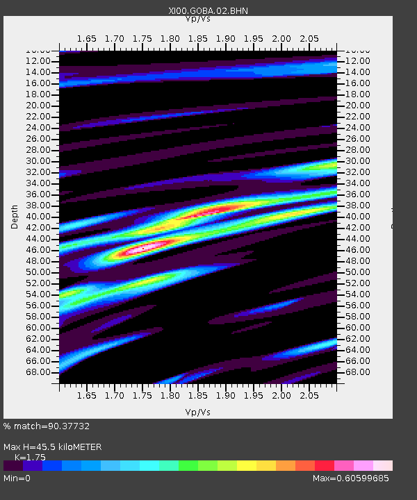
GOBA Goba - Earthquake Result Viewer

Earthquake location: South Sandwich Islands Region
Earthquake latitude/longitude: -59.7/-25.6
Earthquake time(UTC): 2001/04/13 (103) 15:33:53 GMT
Earthquake Depth: 26 km
Earthquake Magnitude: 5.3 MB, 6.0 MS, 6.2 MW, 6.2 MW
Earthquake Catalog/Contributor: WHDF/NEIC
Network: XI Ethiopia/Kenya Broadband Seismic Experiment
Station: GOBA Goba
Lat/Lon: 7.03 N/39.98 E
Elevation: 2732 m
Distance: 84.1 deg
Az: 65.307 deg
Baz: 207.633 deg
Ray Param: 0.045708932
Estimated Moho Depth: 45.5 km
Estimated Crust Vp/Vs: 1.75
Assumed Crust Vp: 6.464 km/s
Estimated Crust Vs: 3.693 km/s
Estimated Crust Poisson's Ratio: 0.26
Radial Match: 90.37732 %
Radial Bump: 400
Transverse Match: 74.095474 %
Transverse Bump: 400
SOD ConfigId: 16820
Insert Time: 2010-03-09 23:48:32.394 +0000
GWidth: 2.5
Max Bumps: 400
Tol: 0.001

Signal To Noise

ChannelStoNSTALTA
XI:GOBA:02:BHN:20010413T15:45:50.562024Z1.29372377.240526E-85.5966552E-8
XI:GOBA:02:BHE:20010413T15:45:50.562024Z0.99821536.016742E-86.0275E-8
XI:GOBA:02:BHZ:20010413T15:45:50.562024Z1.04323948.4172896E-88.068417E-8
Arrivals
Ps5.4 SECOND
PpPs19 SECOND
PsPs/PpSs24 SECOND