
Station XI GOBA - Goba
Network: XI00 - Ethiopia/Kenya Broadband Seismic Experiment
Nearby stations (2 deg radius)
| Station | Name | (Lat, Lon) | Start / End | Elevation |
| GOBA | Goba | (7.03, 39.98) | 2000-03-07 / 2002-12-31 | 2732 m |
| Crust2 Type: | G9,thin custal Archean 0.1 km seds., South American |
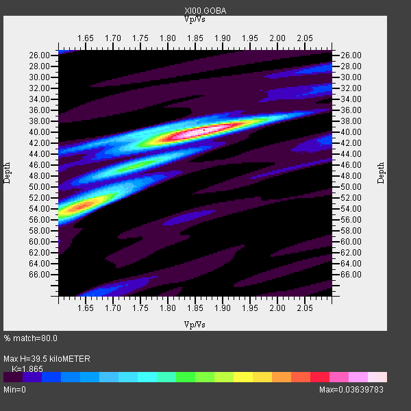
| Thickness Estimate: | 40 km |
| Thickness StdDev: | 5.9 km |
| Vp/Vs Estimate: | 1.87 |
| Vp/Vs StdDev: | 0.10 |
| Vs Estimate: | 3.466 km/s |
| Poisson's Ratio: | 0.30 |
| Peak Value: | 0.04 |
| Assumed Vp: | 6.464 km/s |
| Ps Weight: | 0.33333334 |
| PpPs Weight: | 0.33333334 |
| PsPs Weight: | 0.33333328 |
| Residual Complexity: | 0.548 |
| Nearby stations H: | +- |
| (2.0 deg) Vp/Vs: | +- |
5 with match > 90% ( 50.0 %) and 10 with match > 80% ( 100.0 %) out of 10.
Download stack as xyz text file.
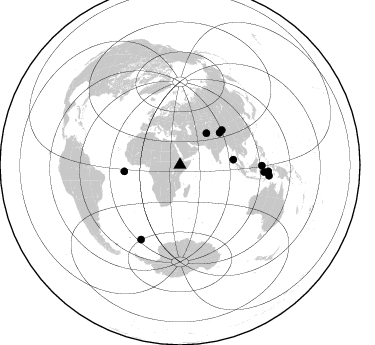
Azimuth Distribution of Events:
Prior Results for this Station
| Study | Thickness | Vp/Vs | Vp | Vs | Poissons Ratio | Extra |
| EARS | 40 km | 1.87 | 6.464 km/s | 3.466 km/s | 0.30 | |
| Crust2.0 | 31 km | 1.76 | 6.464 km/s | 3.663 km/s | 0.26 | G9,thin custal Archean 0.1 km seds., South American |
| Global Maxima | 40 km | 1.87 | 6.464 km/s | 3.466 km/s | 0.30 | amp=0.03639783 |
| Local Maxima 1 | 54 km | 1.64 | 6.464 km/s | 3.935 km/s | 0.21 | amp=0.02648705 |
| Local Maxima 2 | 42 km | 1.81 | 6.464 km/s | 3.581 km/s | 0.28 | amp=0.014370853 |
| Local Maxima 3 | 52 km | 1.68 | 6.464 km/s | 3.842 km/s | 0.23 | amp=0.011943274 |
| Local Maxima 4 | 40 km | 1.76 | 6.464 km/s | 3.672 km/s | 0.26 | amp=0.009530686 |
| Predicted Arrivals for vertical incidence (zero ray parameter) | |
| Ps | 5.29 SECOND |
| PpPs | 17.51 SECOND |
| PsPs/PpSs | 22.79 SECOND |
Events Processed for this Station
Download zip of receiver functions as SAC
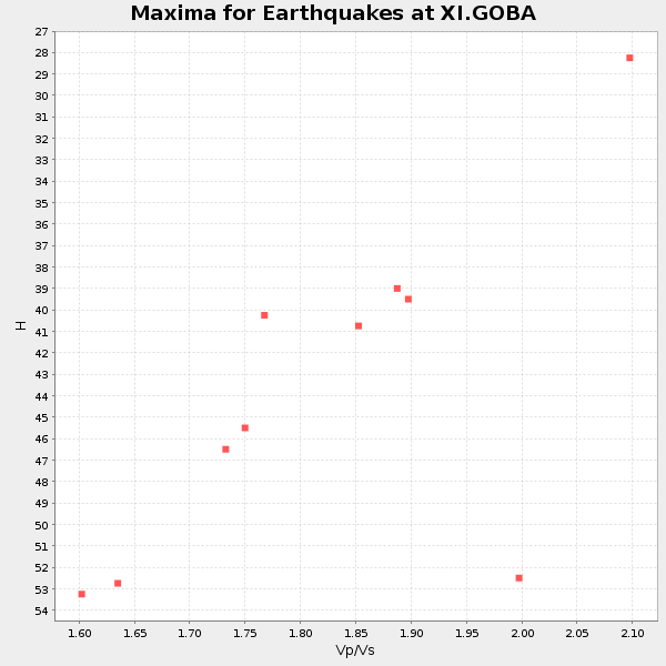
Plot maxima for each earthquake.
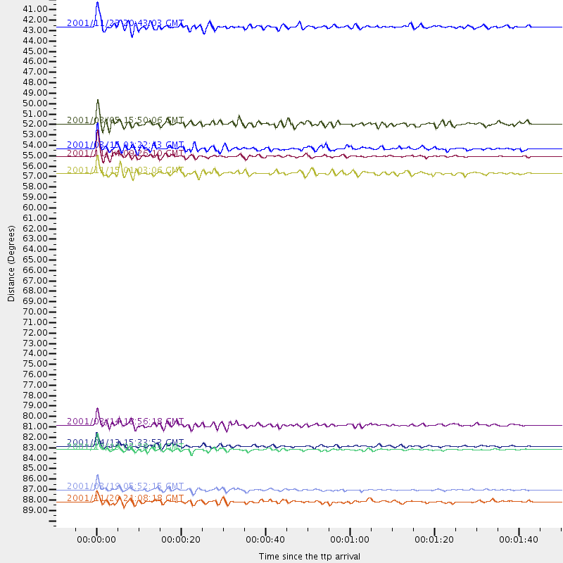
Events Used in the Stack
(10 events)| Radial Match | Distance | Baz | FERegion | Time | Lat/Lon | Depth | Magnitude |
| 97.07591 | 54.4 deg | 50.452 deg | Qinghai, China | 2001/11/14 09:26:10 GMT | (35.9, 90.5) | 10 km | 6.1 MB, 8.0 MS, 7.8 MW, 7.7 MW |
| 94.62472 | 84.5 deg | 94.804 deg | Banda Sea | 2001/10/19 03:28:44 GMT | (-4.1, 123.9) | 33 km | 6.3 MB, 7.3 MS, 7.5 MW, 7.4 MW |
| 91.7178 | 88.5 deg | 94.212 deg | Banda Sea | 2001/03/19 05:52:15 GMT | (-4.0, 128.0) | 33 km | 6.0 MB, 6.5 MS, 6.5 MW, 6.5 MW |
| 91.327934 | 53.5 deg | 84.445 deg | Nicobar Islands, India Region | 2001/03/15 01:22:43 GMT | (8.7, 94.0) | 33 km | 5.6 MB, 5.9 MS, 6.0 MW, 6.0 MW |
| 90.37732 | 84.1 deg | 207.633 deg | South Sandwich Islands Region | 2001/04/13 15:33:53 GMT | (-59.7, -25.6) | 26 km | 5.3 MB, 6.0 MS, 6.2 MW, 6.2 MW |
| 89.662895 | 41.0 deg | 40.001 deg | Afghanistan-Tajikistan Bord Reg. | 2001/11/23 20:43:03 GMT | (36.4, 71.5) | 106 km | 5.9 MB, 6.1 MW, 6.0 MW |
| 87.92775 | 56.1 deg | 263.357 deg | North Of Ascension Island | 2001/11/15 01:03:06 GMT | (-1.6, -15.6) | 10 km | 5.5 MB, 6.0 MS, 6.3 MW, 6.3 MW |
| 82.31428 | 89.8 deg | 96.912 deg | Banda Sea | 2001/11/20 21:08:18 GMT | (-6.9, 128.9) | 33 km | 5.7 MB, 6.0 MS, 6.3 MW, 6.2 MW |
| 82.070984 | 51.0 deg | 51.008 deg | Xizang | 2001/03/05 15:50:06 GMT | (34.4, 86.9) | 33 km | 5.4 MB, 5.8 MS, 5.9 MW, 5.7 MW |
| 80.479744 | 81.9 deg | 90.541 deg | Minahassa Peninsula, Sulawesi | 2001/03/14 18:56:18 GMT | (0.5, 121.9) | 109 km | 5.9 MB, 6.0 MW, 5.9 MW |
Losers
(0 events)| Radial Match | Distance | Baz | FERegion | Time | Lat/Lon | Depth | Magnitude | Reason |
