You are here: Home > Network List > XI00 - Ethiopia/Kenya Broadband Seismic Experiment Stations List
> Station KARA KARAKORE > Earthquake Result Viewer
KARA KARAKORE - Earthquake Result Viewer
| Earthquake location: |
Afghanistan-Tajikistan Bord Reg. |
| Earthquake latitude/longitude: |
36.4/71.5 |
| Earthquake time(UTC): |
2001/11/23 (327) 20:43:03 GMT |
| Earthquake Depth: |
106 km |
| Earthquake Magnitude: |
5.9 MB, 6.1 MW, 6.0 MW |
| Earthquake Catalog/Contributor: |
WHDF/NEIC |
|
| Network: |
XI Ethiopia/Kenya Broadband Seismic Experiment |
| Station: |
KARA KARAKORE |
| Lat/Lon: |
10.42 N/39.93 E |
| Elevation: |
1753 m |
|
| Distance: |
38.5 deg |
| Az: |
235.795 deg |
| Baz: |
42.716 deg |
| Ray Param: |
0.075156815 |
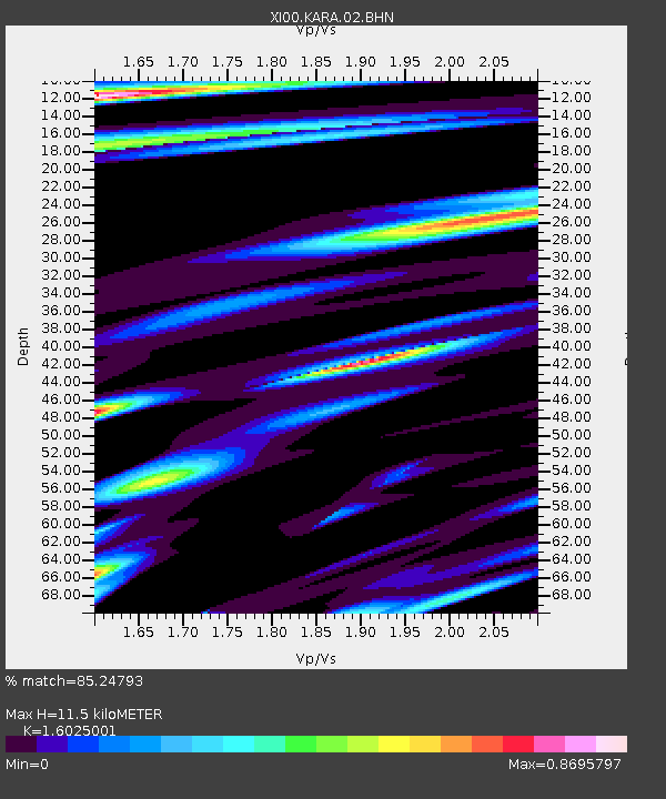
| Estimated Moho Depth: |
11.5 km |
| Estimated Crust Vp/Vs: |
1.60 |
| Assumed Crust Vp: |
6.502 km/s |
| Estimated Crust Vs: |
4.057 km/s |
| Estimated Crust Poisson's Ratio: |
0.18 |
|
| Radial Match: |
85.24793 % |
| Radial Bump: |
400 |
| Transverse Match: |
60.410263 % |
| Transverse Bump: |
400 |
| SOD ConfigId: |
16820 |
| Insert Time: |
2010-03-09 23:49:33.123 +0000 |
| GWidth: |
2.5 |
| Max Bumps: |
400 |
| Tol: |
0.001 |
|

Signal To Noise
| Channel | StoN | STA | LTA |
| XI:KARA:02:BHN:20011123T20:49:45.19801Z | 2.6666057 | 2.3197416E-7 | 8.6992294E-8 |
| XI:KARA:02:BHE:20011123T20:49:45.19801Z | 4.3217793 | 3.0681778E-7 | 7.0993394E-8 |
| XI:KARA:02:BHZ:20011123T20:49:45.19801Z | 6.737265 | 5.4773795E-7 | 8.129975E-8 |
| Arrivals |
| Ps | 1.2 SECOND |
| PpPs | 4.2 SECOND |
| PsPs/PpSs | 5.4 SECOND |


