
Station XI KARA - KARAKORE
Network: XI00 - Ethiopia/Kenya Broadband Seismic Experiment
Nearby stations (2 deg radius)
| Station | Name | (Lat, Lon) | Start / End | Elevation |
| KARA | KARAKORE | (10.42, 39.93) | 2001-03-14 / 2002-12-31 | 1753 m |
| Crust2 Type: | X2,Rift, Rio Grande, Baikal, 0.5km sediments |
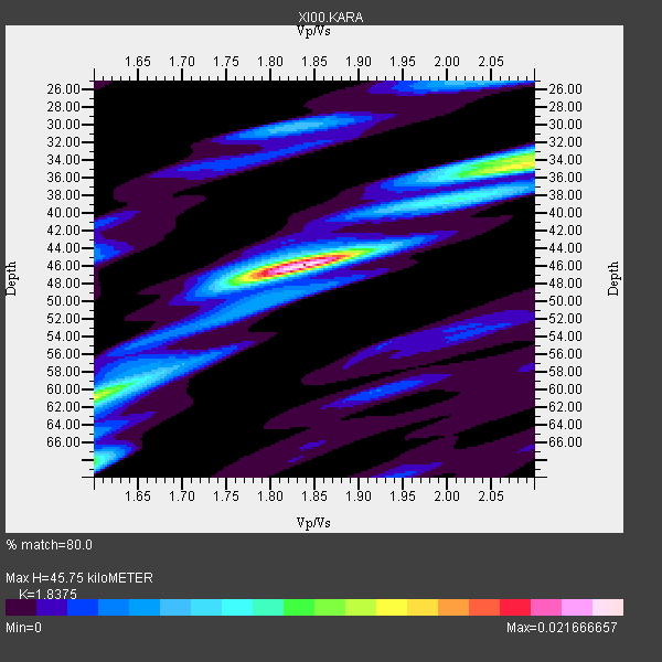
| Thickness Estimate: | 46 km |
| Thickness StdDev: | 8.6 km |
| Vp/Vs Estimate: | 1.84 |
| Vp/Vs StdDev: | 0.15 |
| Vs Estimate: | 3.538 km/s |
| Poisson's Ratio: | 0.29 |
| Peak Value: | 0.02 |
| Assumed Vp: | 6.502 km/s |
| Ps Weight: | 0.33333334 |
| PpPs Weight: | 0.33333334 |
| PsPs Weight: | 0.33333328 |
| Residual Complexity: | 0.613 |
| Nearby stations H: | 42 km +- 4.9 km |
| (2.0 deg) Vp/Vs: | 1.77 +- 0.11 |
4 with match > 90% ( 36.363636 %) and 11 with match > 80% ( 100.0 %) out of 11.
Download stack as xyz text file.
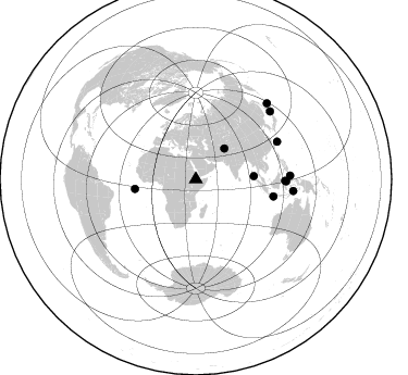
Azimuth Distribution of Events:
Prior Results for this Station
| Study | Thickness | Vp/Vs | Vp | Vs | Poissons Ratio | Extra |
| EARS | 46 km | 1.84 | 6.502 km/s | 3.538 km/s | 0.29 | |
| Crust2.0 | 33 km | 1.77 | 6.502 km/s | 3.68 km/s | 0.26 | X2,Rift, Rio Grande, Baikal, 0.5km sediments |
| Global Maxima | 46 km | 1.84 | 6.502 km/s | 3.538 km/s | 0.29 | amp=0.021666657 |
| Local Maxima 1 | 34 km | 2.09 | 6.502 km/s | 3.114 km/s | 0.35 | amp=0.013654845 |
| Local Maxima 2 | 68 km | 1.60 | 6.502 km/s | 4.063 km/s | 0.18 | amp=0.009982517 |
| Local Maxima 3 | 61 km | 1.60 | 6.502 km/s | 4.063 km/s | 0.18 | amp=0.008886725 |
| Local Maxima 4 | 30 km | 1.83 | 6.502 km/s | 3.562 km/s | 0.29 | amp=0.006403036 |
| Predicted Arrivals for vertical incidence (zero ray parameter) | |
| Ps | 5.89 SECOND |
| PpPs | 19.97 SECOND |
| PsPs/PpSs | 25.86 SECOND |
Events Processed for this Station
Download zip of receiver functions as SAC
Plot maxima for each earthquake.
Events Used in the Stack
(11 events)| Radial Match | Distance | Baz | FERegion | Time | Lat/Lon | Depth | Magnitude |
| 93.57901 | 53.3 deg | 86.939 deg | Nicobar Islands, India Region | 2001/03/15 01:22:43 GMT | (8.7, 94.0) | 33 km | 5.6 MB, 5.9 MS, 6.0 MW, 6.0 MW |
| 91.32064 | 83.1 deg | 91.278 deg | Minahassa Peninsula, Sulawesi | 2001/12/09 18:15:02 GMT | (-0.0, 122.9) | 156 km | 5.7 MB, 6.2 MW, 6.0 MW |
| 90.74453 | 95.7 deg | 43.221 deg | Kuril Islands | 2001/05/25 00:40:50 GMT | (44.3, 148.4) | 33 km | 6.1 MB, 6.7 MS, 6.7 MW, 6.6 MW |
| 90.272194 | 82.2 deg | 65.273 deg | Ryukyu Islands, Japan | 2001/08/17 22:25:49 GMT | (25.7, 126.2) | 33 km | 5.6 MB, 5.6 MS, 5.9 MW, 5.9 MW |
| 89.527855 | 56.5 deg | 261.116 deg | North Of Ascension Island | 2001/11/15 01:03:06 GMT | (-1.6, -15.6) | 10 km | 5.5 MB, 6.0 MS, 6.3 MW, 6.3 MW |
| 87.032555 | 90.2 deg | 96.905 deg | Banda Sea | 2001/11/20 21:08:18 GMT | (-6.9, 128.9) | 33 km | 5.7 MB, 6.0 MS, 6.3 MW, 6.2 MW |
| 85.64553 | 82.0 deg | 91.01 deg | Minahassa Peninsula, Sulawesi | 2001/03/14 18:56:18 GMT | (0.5, 121.9) | 109 km | 5.9 MB, 6.0 MW, 5.9 MW |
| 85.24793 | 38.5 deg | 42.716 deg | Afghanistan-Tajikistan Bord Reg. | 2001/11/23 20:43:03 GMT | (36.4, 71.5) | 106 km | 5.9 MB, 6.1 MW, 6.0 MW |
| 85.05089 | 92.4 deg | 47.684 deg | Hokkaido, Japan Region | 2001/08/13 20:11:23 GMT | (41.0, 142.3) | 38 km | 6.0 MB, 6.3 MS, 6.4 MW, 6.3 ME |
| 83.02673 | 72.9 deg | 102.379 deg | Java, Indonesia | 2001/10/14 01:10:45 GMT | (-8.6, 110.6) | 67 km | 5.6 MB, 5.3 MS, 5.9 MW, 5.8 MW |
| 81.61694 | 86.6 deg | 87.779 deg | Northern Molucca Sea | 2001/08/04 01:44:53 GMT | (2.8, 127.0) | 33 km | 5.8 MB, 5.6 MS, 5.8 MW, 5.8 MW |
Losers
(0 events)| Radial Match | Distance | Baz | FERegion | Time | Lat/Lon | Depth | Magnitude | Reason |
