You are here: Home > Network List > XM99 - Rio Grande Seismic Transect Stations List
> Station NM37 NewMexico37 > Earthquake Result Viewer
NM37 NewMexico37 - Earthquake Result Viewer
| Earthquake location: |
Peru-Brazil Border Region |
| Earthquake latitude/longitude: |
-7.9/-74.4 |
| Earthquake time(UTC): |
2000/11/01 (306) 04:27:45 GMT |
| Earthquake Depth: |
151 km |
| Earthquake Magnitude: |
5.9 MB, 5.9 MW |
| Earthquake Catalog/Contributor: |
WHDF/NEIC |
|
| Network: |
XM Rio Grande Seismic Transect |
| Station: |
NM37 NewMexico37 |
| Lat/Lon: |
35.58 N/108.00 W |
| Elevation: |
2254 m |
|
| Distance: |
53.6 deg |
| Az: |
325.944 deg |
| Baz: |
137.121 deg |
| Ray Param: |
0.065475434 |
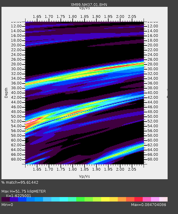
| Estimated Moho Depth: |
51.75 km |
| Estimated Crust Vp/Vs: |
1.62 |
| Assumed Crust Vp: |
6.496 km/s |
| Estimated Crust Vs: |
4.004 km/s |
| Estimated Crust Poisson's Ratio: |
0.19 |
|
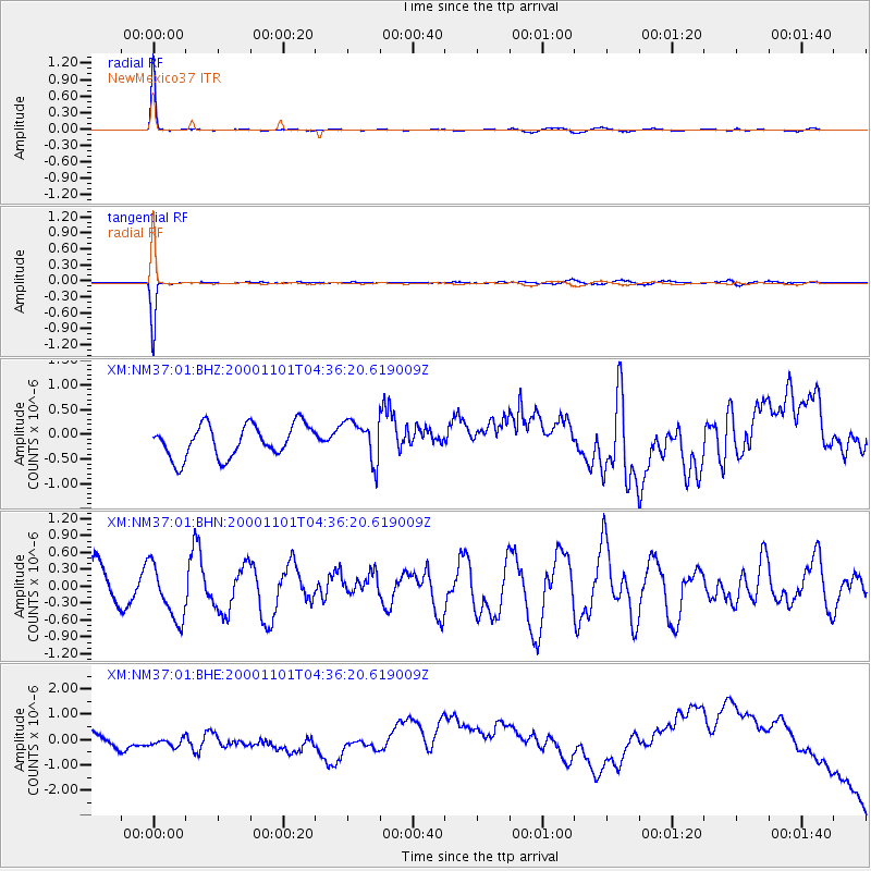
| Radial Match: |
95.61442 % |
| Radial Bump: |
132 |
| Transverse Match: |
94.80907 % |
| Transverse Bump: |
125 |
| SOD ConfigId: |
16820 |
| Insert Time: |
2010-02-26 17:39:53.250 +0000 |
| GWidth: |
2.5 |
| Max Bumps: |
400 |
| Tol: |
0.001 |
|
Signal To Noise
| Channel | StoN | STA | LTA |
| XM:NM37:01:BHN:20001101T04:36:20.619009Z | 1.4105498 | 4.928588E-7 | 3.4940902E-7 |
| XM:NM37:01:BHE:20001101T04:36:20.619009Z | 0.658486 | 2.812603E-7 | 4.2713177E-7 |
| XM:NM37:01:BHZ:20001101T04:36:20.619009Z | 1.2650615 | 4.1631972E-7 | 3.2909048E-7 |
| Arrivals |
| Ps | 5.3 SECOND |
| PpPs | 20 SECOND |
| PsPs/PpSs | 25 SECOND |


