
Station XM NM37 - NewMexico37
Network: XM99 - Rio Grande Seismic Transect
Nearby stations (2 deg radius)
| Station | Name | (Lat, Lon) | Start / End | Elevation |
| NM37 | NewMexico37 | (35.58, -108.00) | 1999-08-04 / 2001-12-31 | 2254 m |
| Crust2 Type: | H7,early/mid Proter. shield, Austr., 1.5 km seds. |
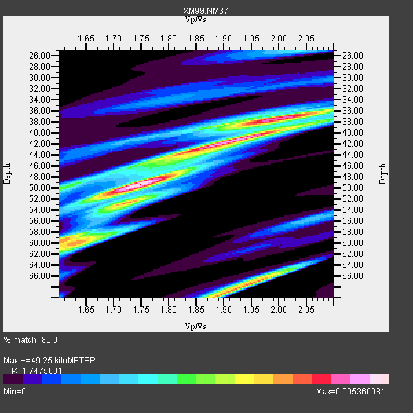
| Thickness Estimate: | 49 km |
| Thickness StdDev: | 12 km |
| Vp/Vs Estimate: | 1.75 |
| Vp/Vs StdDev: | 0.14 |
| Vs Estimate: | 3.717 km/s |
| Poisson's Ratio: | 0.26 |
| Peak Value: | 0.01 |
| Assumed Vp: | 6.496 km/s |
| Ps Weight: | 0.33333334 |
| PpPs Weight: | 0.33333334 |
| PsPs Weight: | 0.33333328 |
| Residual Complexity: | 0.792 |
| Nearby stations H: | +- |
| (2.0 deg) Vp/Vs: | +- |
6 with match > 90% ( 37.5 %) and 14 with match > 80% ( 87.5 %) out of 16.
Download stack as xyz text file.
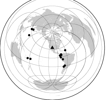
Azimuth Distribution of Events:
Prior Results for this Station
| Study | Thickness | Vp/Vs | Vp | Vs | Poissons Ratio | Extra |
| EARS | 49 km | 1.75 | 6.496 km/s | 3.717 km/s | 0.26 | |
| Crust2.0 | 38 km | 1.78 | 6.496 km/s | 3.647 km/s | 0.27 | H7,early/mid Proter. shield, Austr., 1.5 km seds. |
| Wilson | 46 km | 1.76 | 6.18 km/s | 3.511 km/s | 0.26 | |
| Global Maxima | 49 km | 1.75 | 6.496 km/s | 3.717 km/s | 0.26 | amp=0.005360981 |
| Local Maxima 1 | 41 km | 1.93 | 6.496 km/s | 3.366 km/s | 0.32 | amp=0.0046742246 |
| Local Maxima 2 | 68 km | 1.93 | 6.496 km/s | 3.357 km/s | 0.32 | amp=0.0042764475 |
| Local Maxima 3 | 38 km | 1.99 | 6.496 km/s | 3.273 km/s | 0.33 | amp=0.003713929 |
| Local Maxima 4 | 60 km | 1.60 | 6.496 km/s | 4.06 km/s | 0.18 | amp=0.0030046664 |
| Predicted Arrivals for vertical incidence (zero ray parameter) | |
| Ps | 5.67 SECOND |
| PpPs | 20.83 SECOND |
| PsPs/PpSs | 26.50 SECOND |
Events Processed for this Station
Download zip of receiver functions as SAC
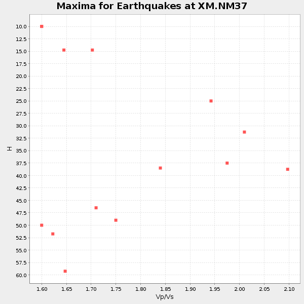
Plot maxima for each earthquake.
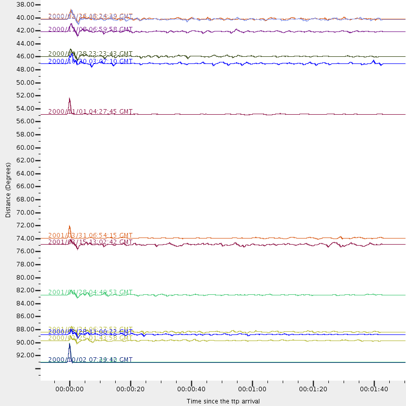
Events Used in the Stack
(14 events)| Radial Match | Distance | Baz | FERegion | Time | Lat/Lon | Depth | Magnitude |
| 99.999275 | 95.7 deg | 312.401 deg | Ryukyu Islands, Japan | 2000/10/02 07:29:42 GMT | (29.4, 129.4) | 33 km | 5.4 MB, 5.1 MS, 5.6 MW, 5.4 MW |
| 99.99896 | 95.7 deg | 312.449 deg | Ryukyu Islands, Japan | 2000/10/02 07:44:10 GMT | (29.5, 129.4) | 33 km | 5.6 MB, 5.2 MS, 5.6 MW, 5.5 MW |
| 97.49594 | 91.0 deg | 298.439 deg | Volcano Islands, Japan Region | 2000/03/28 11:00:22 GMT | (22.3, 143.7) | 126 km | 6.8 MB, 7.6 MS, 7.6 MW, 7.6 MW |
| 95.61442 | 53.6 deg | 137.121 deg | Peru-Brazil Border Region | 2000/11/01 04:27:45 GMT | (-7.9, -74.4) | 151 km | 5.9 MB, 5.9 MW |
| 93.86519 | 39.6 deg | 128.565 deg | Panama-Colombia Border Region | 2000/11/08 06:59:58 GMT | (7.0, -77.8) | 17 km | 6.0 MB, 6.4 MS, 6.5 MW, 6.2 ML |
| 93.76531 | 43.8 deg | 138.318 deg | Near Coast Of Ecuador | 2000/09/28 23:23:43 GMT | (-0.2, -80.6) | 23 km | 5.8 MB, 6.0 MS, 6.6 MW, 6.4 MW |
| 89.61168 | 74.7 deg | 144.713 deg | San Juan Province, Argentina | 2001/03/31 06:54:15 GMT | (-29.4, -68.3) | 104 km | 5.5 MB, 5.5 MW, 5.4 MW |
| 89.5009 | 37.5 deg | 135.697 deg | South Of Panama | 2000/12/12 05:26:45 GMT | (6.0, -82.7) | 10 km | 5.8 MB, 5.7 MS, 6.3 ME, 6.1 MW |
| 88.3227 | 84.2 deg | 243.156 deg | Fiji Islands Region | 2001/04/28 04:49:53 GMT | (-18.1, -176.9) | 352 km | 6.2 MB, 6.8 MW, 6.8 MW |
| 88.049934 | 45.1 deg | 100.795 deg | Leeward Islands | 2000/10/30 03:07:10 GMT | (17.6, -61.2) | 33 km | 5.3 MB, 5.6 MS, 5.8 MW, 5.5 MD |
| 86.836494 | 92.0 deg | 247.48 deg | Vanuatu Islands Region | 2000/02/25 01:43:58 GMT | (-19.5, 173.8) | 33 km | 6.1 MB, 7.1 MS, 7.1 MW, 7.0 MW |
| 86.4336 | 37.4 deg | 126.957 deg | Panama | 2000/02/26 18:24:39 GMT | (9.4, -78.5) | 65 km | 5.8 MB, 5.4 MS, 6.2 MW, 6.1 MW |
| 82.347015 | 90.6 deg | 313.731 deg | Western Honshu, Japan | 2001/03/24 06:27:53 GMT | (34.1, 132.5) | 50 km | 6.4 MB, 6.5 MS, 6.8 MW, 6.4 ME |
| 81.46209 | 75.7 deg | 148.682 deg | Near Coast Of Central Chile | 2001/03/15 13:02:42 GMT | (-32.3, -71.5) | 37 km | 6.1 MB, 5.6 MS, 6.0 MW, 5.4 MD |
Losers
(2 events)| Radial Match | Distance | Baz | FERegion | Time | Lat/Lon | Depth | Magnitude | Reason |
| 99.08349 | 91.1 deg | 234.307 deg | Kermadec Islands Region | 2000/07/31 23:01:49 GMT | (-29.3, -176.4) | 10 km | 5.5 MB, 5.9 MS, 6.1 MW, 5.9 MW | |
| 81.33682 | 94.3 deg | 260.155 deg | Santa Cruz Islands Region | 2000/12/22 08:30:39 GMT | (-10.6, 164.2) | 33 km | 5.5 MB, 5.4 MS, 5.9 MW, 5.8 MW |
