You are here: Home > Network List > XI00 - Ethiopia/Kenya Broadband Seismic Experiment Stations List
> Station NEKE NEKEMTE > Earthquake Result Viewer
NEKE NEKEMTE - Earthquake Result Viewer
| Earthquake location: |
Afghanistan-Tajikistan Bord Reg. |
| Earthquake latitude/longitude: |
36.4/71.5 |
| Earthquake time(UTC): |
2001/11/23 (327) 20:43:03 GMT |
| Earthquake Depth: |
106 km |
| Earthquake Magnitude: |
5.9 MB, 6.1 MW, 6.0 MW |
| Earthquake Catalog/Contributor: |
WHDF/NEIC |
|
| Network: |
XI Ethiopia/Kenya Broadband Seismic Experiment |
| Station: |
NEKE NEKEMTE |
| Lat/Lon: |
9.09 N/36.52 E |
| Elevation: |
2080 m |
|
| Distance: |
41.8 deg |
| Az: |
238.178 deg |
| Baz: |
43.963 deg |
| Ray Param: |
0.07320416 |
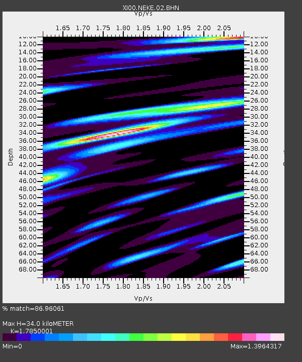
| Estimated Moho Depth: |
34.0 km |
| Estimated Crust Vp/Vs: |
1.79 |
| Assumed Crust Vp: |
6.404 km/s |
| Estimated Crust Vs: |
3.588 km/s |
| Estimated Crust Poisson's Ratio: |
0.27 |
|
| Radial Match: |
86.96061 % |
| Radial Bump: |
400 |
| Transverse Match: |
80.32573 % |
| Transverse Bump: |
400 |
| SOD ConfigId: |
16820 |
| Insert Time: |
2010-03-09 23:50:29.017 +0000 |
| GWidth: |
2.5 |
| Max Bumps: |
400 |
| Tol: |
0.001 |
|

Signal To Noise
| Channel | StoN | STA | LTA |
| XI:NEKE:02:BHN:20011123T20:50:12.150006Z | 6.979214 | 4.2314505E-7 | 6.0629326E-8 |
| XI:NEKE:02:BHE:20011123T20:50:12.150006Z | 3.8948035 | 2.9411007E-7 | 7.5513455E-8 |
| XI:NEKE:02:BHZ:20011123T20:50:12.150006Z | 16.757158 | 8.4666027E-7 | 5.052529E-8 |
| Arrivals |
| Ps | 4.5 SECOND |
| PpPs | 14 SECOND |
| PsPs/PpSs | 18 SECOND |


