
Station XI NEKE - NEKEMTE
Network: XI00 - Ethiopia/Kenya Broadband Seismic Experiment
Nearby stations (2 deg radius)
| Station | Name | (Lat, Lon) | Start / End | Elevation |
| NEKE | NEKEMTE | (9.09, 36.52) | 2001-03-05 / 2002-12-31 | 2080 m |
| Crust2 Type: | GH,thin Archean 0.5 km seds. |
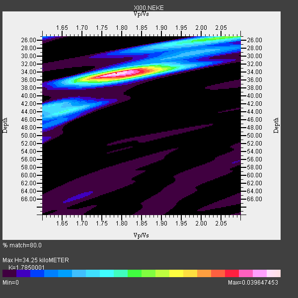
| Thickness Estimate: | 34 km |
| Thickness StdDev: | 2.4 km |
| Vp/Vs Estimate: | 1.79 |
| Vp/Vs StdDev: | 0.07 |
| Vs Estimate: | 3.588 km/s |
| Poisson's Ratio: | 0.27 |
| Peak Value: | 0.04 |
| Assumed Vp: | 6.404 km/s |
| Ps Weight: | 0.33333334 |
| PpPs Weight: | 0.33333334 |
| PsPs Weight: | 0.33333328 |
| Residual Complexity: | 0.525 |
| Nearby stations H: | +- |
| (2.0 deg) Vp/Vs: | +- |
4 with match > 90% ( 36.363636 %) and 11 with match > 80% ( 100.0 %) out of 11.
Download stack as xyz text file.
Azimuth Distribution of Events:

Prior Results for this Station
| Study | Thickness | Vp/Vs | Vp | Vs | Poissons Ratio | Extra |
| EARS | 34 km | 1.79 | 6.404 km/s | 3.588 km/s | 0.27 | |
| Crust2.0 | 35 km | 1.76 | 6.404 km/s | 3.629 km/s | 0.26 | GH,thin Archean 0.5 km seds. |
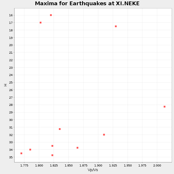
| Global Maxima | 34 km | 1.79 | 6.404 km/s | 3.588 km/s | 0.27 | amp=0.039647453 |
| Local Maxima 1 | 25 km | 2.07 | 6.404 km/s | 3.098 km/s | 0.35 | amp=0.02014242 |
| Local Maxima 2 | 35 km | 1.83 | 6.404 km/s | 3.5 km/s | 0.29 | amp=0.019200552 |
| Local Maxima 3 | 44 km | 1.65 | 6.404 km/s | 3.87 km/s | 0.21 | amp=0.011661563 |
| Local Maxima 4 | 28 km | 1.88 | 6.404 km/s | 3.411 km/s | 0.30 | amp=0.0067598918 |
| Predicted Arrivals for vertical incidence (zero ray parameter) | |
| Ps | 4.20 SECOND |
| PpPs | 14.89 SECOND |
| PsPs/PpSs | 19.09 SECOND |
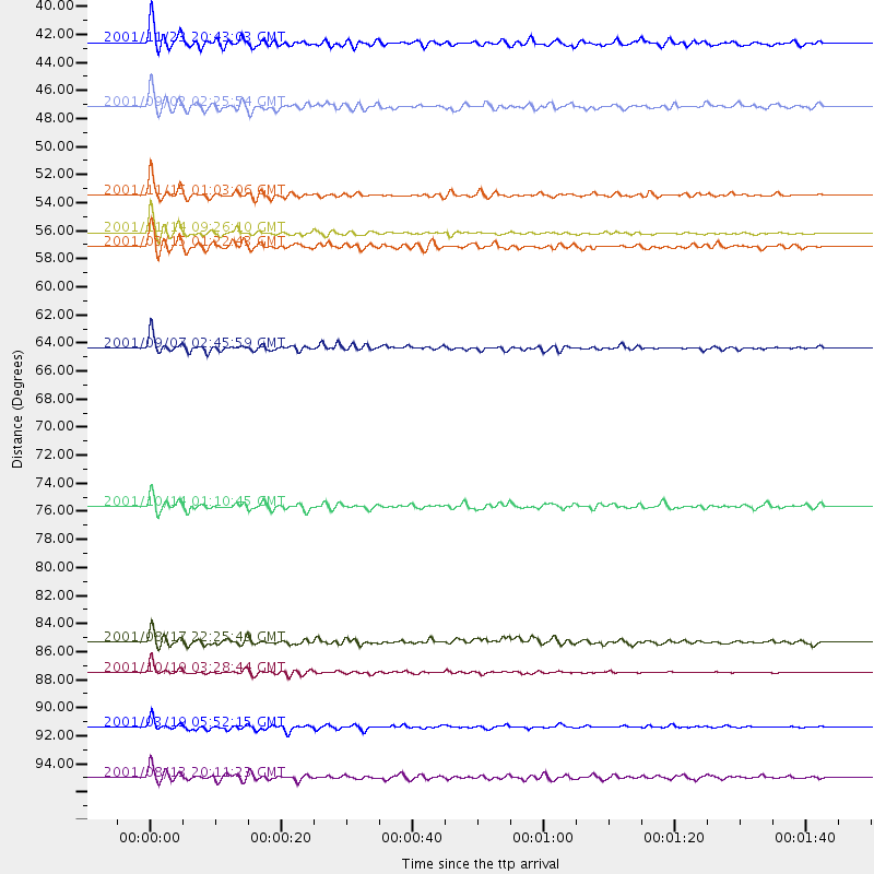
Events Processed for this Station
Download zip of receiver functions as SAC
Plot maxima for each earthquake.
Events Used in the Stack
(11 events)| Radial Match | Distance | Baz | FERegion | Time | Lat/Lon | Depth | Magnitude |
| 95.64889 | 88.1 deg | 94.437 deg | Banda Sea | 2001/10/19 03:28:44 GMT | (-4.1, 123.9) | 33 km | 6.3 MB, 7.3 MS, 7.5 MW, 7.4 MW |
| 94.98836 | 53.0 deg | 261.099 deg | North Of Ascension Island | 2001/11/15 01:03:06 GMT | (-1.6, -15.6) | 10 km | 5.5 MB, 6.0 MS, 6.3 MW, 6.3 MW |
| 92.98122 | 55.8 deg | 52.58 deg | Qinghai, China | 2001/11/14 09:26:10 GMT | (35.9, 90.5) | 10 km | 6.1 MB, 8.0 MS, 7.8 MW, 7.7 MW |
| 91.570114 | 64.3 deg | 109.329 deg | South Indian Ocean | 2001/09/07 02:45:59 GMT | (-13.2, 97.3) | 10 km | 6.2 MB, 5.8 MS, 6.0 MW, 5.9 MW |
| 88.58778 | 92.1 deg | 93.72 deg | Banda Sea | 2001/03/19 05:52:15 GMT | (-4.0, 128.0) | 33 km | 6.0 MB, 6.5 MS, 6.5 MW, 6.5 MW |
| 88.1451 | 56.8 deg | 85.593 deg | Nicobar Islands, India Region | 2001/03/15 01:22:43 GMT | (8.7, 94.0) | 33 km | 5.6 MB, 5.9 MS, 6.0 MW, 6.0 MW |
| 86.96061 | 41.8 deg | 43.963 deg | Afghanistan-Tajikistan Bord Reg. | 2001/11/23 20:43:03 GMT | (36.4, 71.5) | 106 km | 5.9 MB, 6.1 MW, 6.0 MW |
| 86.8203 | 95.8 deg | 47.016 deg | Hokkaido, Japan Region | 2001/08/13 20:11:23 GMT | (41.0, 142.3) | 38 km | 6.0 MB, 6.3 MS, 6.4 MW, 6.3 ME |
| 85.99521 | 85.8 deg | 64.722 deg | Ryukyu Islands, Japan | 2001/08/17 22:25:49 GMT | (25.7, 126.2) | 33 km | 5.6 MB, 5.6 MS, 5.9 MW, 5.9 MW |
| 85.06011 | 46.5 deg | 97.435 deg | North Indian Ocean | 2001/09/02 02:25:54 GMT | (0.9, 82.5) | 10 km | 5.6 MB, 5.8 MS, 6.1 MW, 6.1 MW |
| 80.294914 | 75.9 deg | 101.249 deg | Java, Indonesia | 2001/10/14 01:10:45 GMT | (-8.6, 110.6) | 67 km | 5.6 MB, 5.3 MS, 5.9 MW, 5.8 MW |
Losers
(0 events)| Radial Match | Distance | Baz | FERegion | Time | Lat/Lon | Depth | Magnitude | Reason |
