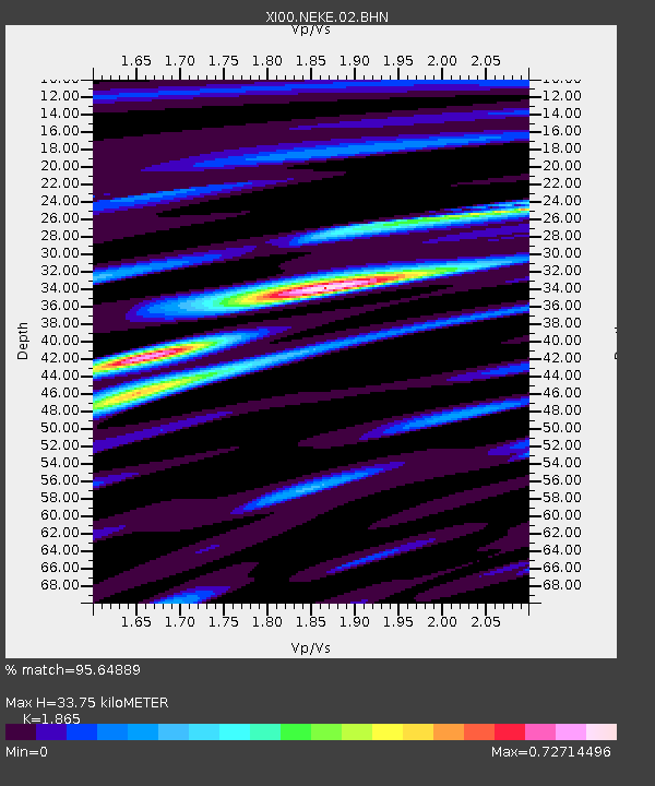
NEKE NEKEMTE - Earthquake Result Viewer

Earthquake location: Banda Sea
Earthquake latitude/longitude: -4.1/123.9
Earthquake time(UTC): 2001/10/19 (292) 03:28:44 GMT
Earthquake Depth: 33 km
Earthquake Magnitude: 6.3 MB, 7.3 MS, 7.5 MW, 7.4 MW
Earthquake Catalog/Contributor: WHDF/NEIC
Network: XI Ethiopia/Kenya Broadband Seismic Experiment
Station: NEKE NEKEMTE
Lat/Lon: 9.09 N/36.52 E
Elevation: 2080 m
Distance: 88.1 deg
Az: 279.197 deg
Baz: 94.437 deg
Ray Param: 0.04282353
Estimated Moho Depth: 33.75 km
Estimated Crust Vp/Vs: 1.87
Assumed Crust Vp: 6.404 km/s
Estimated Crust Vs: 3.434 km/s
Estimated Crust Poisson's Ratio: 0.30
Radial Match: 95.64889 %
Radial Bump: 400
Transverse Match: 84.518196 %
Transverse Bump: 400
SOD ConfigId: 16820
Insert Time: 2010-03-09 23:50:32.455 +0000
GWidth: 2.5
Max Bumps: 400
Tol: 0.001

Signal To Noise

ChannelStoNSTALTA
XI:NEKE:02:BHN:20011019T03:41:00.249001Z2.30888251.2165752E-65.2691087E-7
XI:NEKE:02:BHE:20011019T03:41:00.249001Z2.48589351.2828252E-65.160419E-7
XI:NEKE:02:BHZ:20011019T03:41:00.249001Z2.1646885.247489E-72.4241314E-7
Arrivals
Ps4.7 SECOND
PpPs15 SECOND
PsPs/PpSs19 SECOND