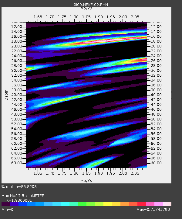
NEKE NEKEMTE - Earthquake Result Viewer

Earthquake location: Hokkaido, Japan Region
Earthquake latitude/longitude: 41.0/142.3
Earthquake time(UTC): 2001/08/13 (225) 20:11:23 GMT
Earthquake Depth: 38 km
Earthquake Magnitude: 6.0 MB, 6.3 MS, 6.4 MW, 6.3 ME
Earthquake Catalog/Contributor: WHDF/NEIC
Network: XI Ethiopia/Kenya Broadband Seismic Experiment
Station: NEKE NEKEMTE
Lat/Lon: 9.09 N/36.52 E
Elevation: 2080 m
Distance: 95.8 deg
Az: 287.214 deg
Baz: 47.016 deg
Ray Param: 0.04067592
Estimated Moho Depth: 17.5 km
Estimated Crust Vp/Vs: 1.93
Assumed Crust Vp: 6.404 km/s
Estimated Crust Vs: 3.318 km/s
Estimated Crust Poisson's Ratio: 0.32
Radial Match: 86.8203 %
Radial Bump: 400
Transverse Match: 64.14725 %
Transverse Bump: 400
SOD ConfigId: 16820
Insert Time: 2010-03-09 23:50:40.671 +0000
GWidth: 2.5
Max Bumps: 400
Tol: 0.001

Signal To Noise

ChannelStoNSTALTA
XI:NEKE:02:BHN:20010813T20:24:14.155005Z1.15130018.9528754E-87.7763175E-8
XI:NEKE:02:BHE:20010813T20:24:14.155005Z1.23634248.5850175E-86.943883E-8
XI:NEKE:02:BHZ:20010813T20:24:14.155005Z4.27051972.1506877E-75.0361265E-8
Arrivals
Ps2.6 SECOND
PpPs7.9 SECOND
PsPs/PpSs10 SECOND