You are here: Home > Network List > XI00 - Ethiopia/Kenya Broadband Seismic Experiment Stations List
> Station TEND Tendaho > Earthquake Result Viewer
TEND Tendaho - Earthquake Result Viewer
| Earthquake location: |
South Sandwich Islands Region |
| Earthquake latitude/longitude: |
-56.0/-27.3 |
| Earthquake time(UTC): |
2002/03/09 (068) 12:27:11 GMT |
| Earthquake Depth: |
118 km |
| Earthquake Magnitude: |
5.8 MB, 6.0 MW, 6.0 MW |
| Earthquake Catalog/Contributor: |
WHDF/NEIC |
|
| Network: |
XI Ethiopia/Kenya Broadband Seismic Experiment |
| Station: |
TEND Tendaho |
| Lat/Lon: |
11.79 N/41.00 E |
| Elevation: |
419 m |
|
| Distance: |
88.0 deg |
| Az: |
65.583 deg |
| Baz: |
211.477 deg |
| Ray Param: |
0.042658444 |
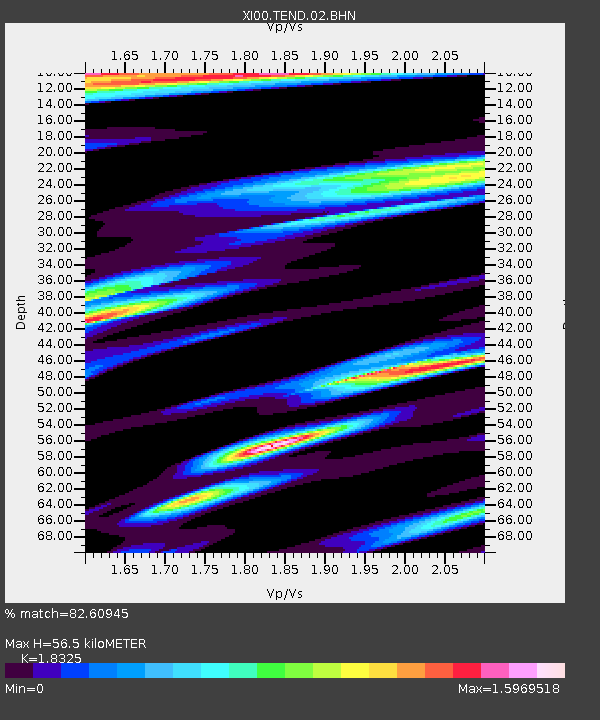
| Estimated Moho Depth: |
56.5 km |
| Estimated Crust Vp/Vs: |
1.83 |
| Assumed Crust Vp: |
6.375 km/s |
| Estimated Crust Vs: |
3.479 km/s |
| Estimated Crust Poisson's Ratio: |
0.29 |
|
| Radial Match: |
82.60945 % |
| Radial Bump: |
400 |
| Transverse Match: |
73.87582 % |
| Transverse Bump: |
400 |
| SOD ConfigId: |
16820 |
| Insert Time: |
2010-03-09 23:51:34.661 +0000 |
| GWidth: |
2.5 |
| Max Bumps: |
400 |
| Tol: |
0.001 |
|

Signal To Noise
| Channel | StoN | STA | LTA |
| XI:TEND:02:BHN:20020309T12:39:16.837004Z | 0.5840888 | 1.0645291E-7 | 1.8225467E-7 |
| XI:TEND:02:BHE:20020309T12:39:16.837004Z | 0.59133023 | 1.1318087E-7 | 1.9140043E-7 |
| XI:TEND:02:BHZ:20020309T12:39:16.837004Z | 0.8449842 | 8.8668294E-8 | 1.04934855E-7 |
| Arrivals |
| Ps | 7.5 SECOND |
| PpPs | 25 SECOND |
| PsPs/PpSs | 32 SECOND |


