You are here: Home > Network List > XI00 - Ethiopia/Kenya Broadband Seismic Experiment Stations List
> Station TEND Tendaho > Earthquake Result Viewer
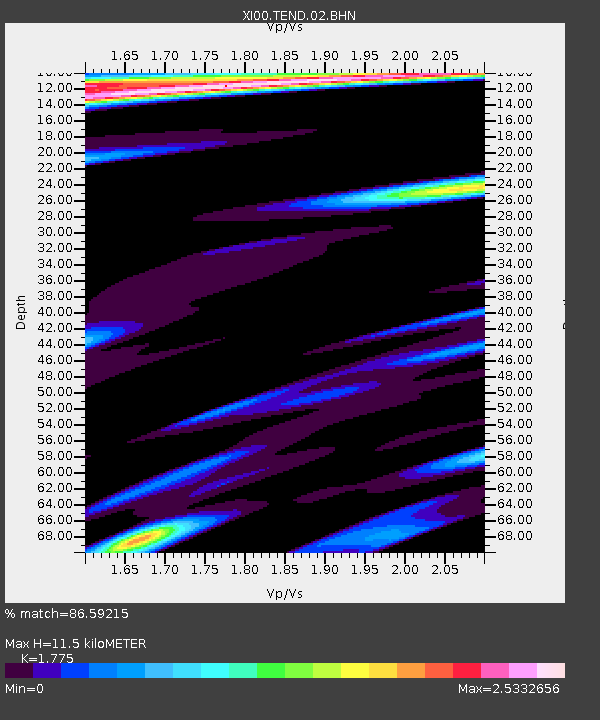
TEND Tendaho - Earthquake Result Viewer
| Earthquake location: |
Hindu Kush Region, Afghanistan |
| Earthquake latitude/longitude: |
36.1/70.7 |
| Earthquake time(UTC): |
2002/01/03 (003) 07:05:27 GMT |
| Earthquake Depth: |
129 km |
| Earthquake Magnitude: |
5.8 MB, 6.2 MW, 6.1 MW |
| Earthquake Catalog/Contributor: |
WHDF/NEIC |
|
| Network: |
XI Ethiopia/Kenya Broadband Seismic Experiment |
| Station: |
TEND Tendaho |
| Lat/Lon: |
11.79 N/41.00 E |
| Elevation: |
419 m |
|
| Distance: |
36.1 deg |
| Az: |
235.408 deg |
| Baz: |
42.92 deg |
| Ray Param: |
0.07643221 |
| Estimated Moho Depth: |
11.5 km |
| Estimated Crust Vp/Vs: |
1.77 |
| Assumed Crust Vp: |
6.375 km/s |
| Estimated Crust Vs: |
3.592 km/s |
| Estimated Crust Poisson's Ratio: |
0.27 |
|
| Radial Match: |
86.59215 % |
| Radial Bump: |
400 |
| Transverse Match: |
67.86887 % |
| Transverse Bump: |
400 |
| SOD ConfigId: |
16820 |
| Insert Time: |
2010-03-09 23:51:41.210 +0000 |
| GWidth: |
2.5 |
| Max Bumps: |
400 |
| Tol: |
0.001 |
|

Signal To Noise
| Channel | StoN | STA | LTA |
| XI:TEND:02:BHN:20020103T07:11:46.603014Z | 1.1642867 | 4.733752E-7 | 4.0657955E-7 |
| XI:TEND:02:BHE:20020103T07:11:46.603014Z | 1.0008656 | 4.1038692E-7 | 4.1003202E-7 |
| XI:TEND:02:BHZ:20020103T07:11:46.603014Z | 1.8560671 | 1.057686E-6 | 5.6985334E-7 |
| Arrivals |
| Ps | 1.5 SECOND |
| PpPs | 4.7 SECOND |
| PsPs/PpSs | 6.2 SECOND |


