You are here: Home > Network List > XI00 - Ethiopia/Kenya Broadband Seismic Experiment Stations List
> Station WANE GEWANE > Earthquake Result Viewer
WANE GEWANE - Earthquake Result Viewer
| Earthquake location: |
Minahassa Peninsula, Sulawesi |
| Earthquake latitude/longitude: |
-0.0/122.9 |
| Earthquake time(UTC): |
2001/12/09 (343) 18:15:02 GMT |
| Earthquake Depth: |
156 km |
| Earthquake Magnitude: |
5.7 MB, 6.2 MW, 6.0 MW |
| Earthquake Catalog/Contributor: |
WHDF/NEIC |
|
| Network: |
XI Ethiopia/Kenya Broadband Seismic Experiment |
| Station: |
WANE GEWANE |
| Lat/Lon: |
10.17 N/40.65 E |
| Elevation: |
606 m |
|
| Distance: |
82.3 deg |
| Az: |
280.195 deg |
| Baz: |
91.375 deg |
| Ray Param: |
0.046588458 |
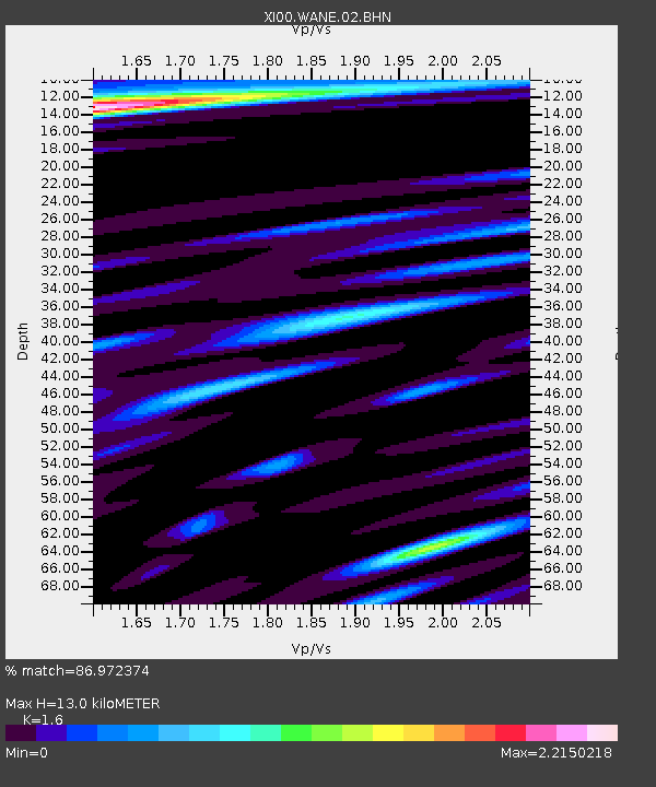
| Estimated Moho Depth: |
13.0 km |
| Estimated Crust Vp/Vs: |
1.60 |
| Assumed Crust Vp: |
6.375 km/s |
| Estimated Crust Vs: |
3.984 km/s |
| Estimated Crust Poisson's Ratio: |
0.18 |
|
| Radial Match: |
86.972374 % |
| Radial Bump: |
400 |
| Transverse Match: |
84.0546 % |
| Transverse Bump: |
400 |
| SOD ConfigId: |
16820 |
| Insert Time: |
2010-03-09 23:52:12.162 +0000 |
| GWidth: |
2.5 |
| Max Bumps: |
400 |
| Tol: |
0.001 |
|

Signal To Noise
| Channel | StoN | STA | LTA |
| XI:WANE:02:BHN:20011209T18:26:35.805017Z | 0.9576121 | 1.3183087E-7 | 1.3766626E-7 |
| XI:WANE:02:BHE:20011209T18:26:35.805017Z | 1.1447681 | 2.1629995E-7 | 1.8894652E-7 |
| XI:WANE:02:BHZ:20011209T18:26:35.805017Z | 2.473204 | 2.8026452E-7 | 1.13320425E-7 |
| Arrivals |
| Ps | 1.3 SECOND |
| PpPs | 5.2 SECOND |
| PsPs/PpSs | 6.4 SECOND |


