
Station XI WANE - GEWANE
Network: XI00 - Ethiopia/Kenya Broadband Seismic Experiment
Nearby stations (2 deg radius)
| Station | Name | (Lat, Lon) | Start / End | Elevation |
| WANE | GEWANE | (10.17, 40.65) | 2001-03-10 / 2002-12-31 | 606 m |
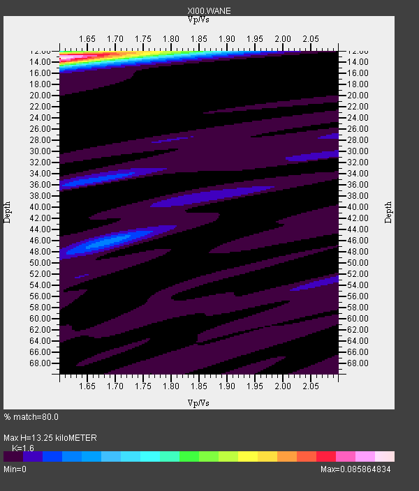
| Crust2 Type: | X4,very thin Afar Rift 0.75 km sediments |
| Thickness Estimate: | 13 km |
| Thickness StdDev: | 0.2 km |
| Vp/Vs Estimate: | 1.60 |
| Vp/Vs StdDev: | 0.00 |
| Vs Estimate: | 3.984 km/s |
| Poisson's Ratio: | 0.18 |
| Peak Value: | 0.09 |
| Assumed Vp: | 6.375 km/s |
| Ps Weight: | 0.33333334 |
| PpPs Weight: | 0.33333334 |
| PsPs Weight: | 0.33333328 |
| Residual Complexity: | 0.264 |
| Nearby stations H: | +- |
| (2.0 deg) Vp/Vs: | +- |
7 with match > 90% ( 30.434782 %) and 23 with match > 80% ( 100.0 %) out of 23.
Download stack as xyz text file.
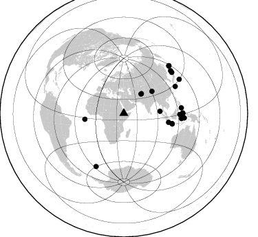
Azimuth Distribution of Events:
Prior Results for this Station
| Study | Thickness | Vp/Vs | Vp | Vs | Poissons Ratio | Extra |
| EARS | 13 km | 1.60 | 6.375 km/s | 3.984 km/s | 0.18 | |
| Crust2.0 | 17 km | 1.77 | 6.375 km/s | 3.604 km/s | 0.27 | X4,very thin Afar Rift 0.75 km sediments |
| Global Maxima | 13 km | 1.60 | 6.375 km/s | 3.984 km/s | 0.18 | amp=0.085864834 |
| Local Maxima 1 | 12 km | 1.60 | 6.375 km/s | 3.984 km/s | 0.18 | amp=0.035132393 |
| Local Maxima 2 | 15 km | 1.61 | 6.375 km/s | 3.966 km/s | 0.18 | amp=0.010922868 |
| Local Maxima 3 | 35 km | 1.68 | 6.375 km/s | 3.8 km/s | 0.22 | amp=0.0108902 |
| Local Maxima 4 | 46 km | 1.68 | 6.375 km/s | 3.806 km/s | 0.22 | amp=0.009420931 |
| Predicted Arrivals for vertical incidence (zero ray parameter) | |
| Ps | 1.25 SECOND |
| PpPs | 5.40 SECOND |
| PsPs/PpSs | 6.65 SECOND |
Events Processed for this Station
Download zip of receiver functions as SAC
Plot maxima for each earthquake.
Events Used in the Stack
(23 events)| Radial Match | Distance | Baz | FERegion | Time | Lat/Lon | Depth | Magnitude |
| 96.71834 | 37.5 deg | 41.746 deg | Hindu Kush Region, Afghanistan | 2002/01/03 07:05:27 GMT | (36.1, 70.7) | 129 km | 5.8 MB, 6.2 MW, 6.1 MW |
| 93.86556 | 84.1 deg | 95.22 deg | Banda Sea | 2001/10/19 03:28:44 GMT | (-4.1, 123.9) | 33 km | 6.3 MB, 7.3 MS, 7.5 MW, 7.4 MW |
| 93.24851 | 51.9 deg | 52.069 deg | Qinghai, China | 2001/11/14 09:26:10 GMT | (35.9, 90.5) | 10 km | 6.1 MB, 8.0 MS, 7.8 MW, 7.7 MW |
| 93.082375 | 52.6 deg | 86.847 deg | Nicobar Islands, India Region | 2001/03/15 01:22:43 GMT | (8.7, 94.0) | 33 km | 5.6 MB, 5.9 MS, 6.0 MW, 6.0 MW |
| 93.072105 | 88.1 deg | 94.403 deg | Banda Sea | 2001/03/19 05:52:15 GMT | (-4.0, 128.0) | 33 km | 6.0 MB, 6.5 MS, 6.5 MW, 6.5 MW |
| 92.43695 | 87.1 deg | 207.666 deg | South Sandwich Islands Region | 2001/04/13 15:33:53 GMT | (-59.7, -25.6) | 26 km | 5.3 MB, 6.0 MS, 6.2 MW, 6.2 MW |
| 92.301155 | 95.4 deg | 43.413 deg | Kuril Islands | 2001/05/25 00:40:50 GMT | (44.3, 148.4) | 33 km | 6.1 MB, 6.7 MS, 6.7 MW, 6.6 MW |
| 89.91548 | 57.2 deg | 261.475 deg | North Of Ascension Island | 2001/11/15 01:03:06 GMT | (-1.6, -15.6) | 10 km | 5.5 MB, 6.0 MS, 6.3 MW, 6.3 MW |
| 89.36391 | 66.3 deg | 101.491 deg | Sunda Strait, Indonesia | 2002/01/15 07:12:58 GMT | (-6.3, 105.2) | 10 km | 5.8 MB, 6.3 MS, 6.2 MW, 6.1 MW |
| 89.349884 | 84.3 deg | 62.423 deg | Ryukyu Islands, Japan | 2001/12/08 20:29:34 GMT | (28.3, 129.6) | 33 km | 5.7 MB, 5.7 MS, 6.2 MW, 6.1 MW |
| 88.58062 | 85.3 deg | 89.998 deg | Northern Molucca Sea | 2001/10/13 16:27:00 GMT | (0.8, 126.0) | 33 km | 5.6 MB, 5.7 MS, 6.0 MW, 5.8 MW |
| 87.7105 | 94.4 deg | 58.533 deg | Southeast Of Honshu, Japan | 2001/04/14 23:27:26 GMT | (30.1, 141.8) | 10 km | 6.0 MB, 5.8 MS, 6.0 MW, 6.0 ME |
| 87.56439 | 92.0 deg | 47.836 deg | Hokkaido, Japan Region | 2001/08/13 20:11:23 GMT | (41.0, 142.3) | 38 km | 6.0 MB, 6.3 MS, 6.4 MW, 6.3 ME |
| 87.498436 | 38.2 deg | 41.972 deg | Afghanistan-Tajikistan Bord Reg. | 2001/11/23 20:43:03 GMT | (36.4, 71.5) | 106 km | 5.9 MB, 6.1 MW, 6.0 MW |
| 87.34636 | 91.6 deg | 49.663 deg | Eastern Honshu, Japan | 2001/12/02 13:01:53 GMT | (39.4, 141.1) | 124 km | 6.1 MB, 6.5 MW, 6.5 MW |
| 86.972374 | 82.3 deg | 91.375 deg | Minahassa Peninsula, Sulawesi | 2001/12/09 18:15:02 GMT | (-0.0, 122.9) | 156 km | 5.7 MB, 6.2 MW, 6.0 MW |
| 86.95419 | 81.3 deg | 91.102 deg | Minahassa Peninsula, Sulawesi | 2001/03/14 18:56:18 GMT | (0.5, 121.9) | 109 km | 5.9 MB, 6.0 MW, 5.9 MW |
| 85.7647 | 84.0 deg | 84.682 deg | Mindanao, Philippines | 2002/01/01 11:29:22 GMT | (6.3, 125.7) | 138 km | 5.9 MB, 6.3 MW, 6.3 MW |
| 85.57581 | 71.5 deg | 101.846 deg | Java, Indonesia | 2001/05/25 05:06:10 GMT | (-7.9, 110.2) | 143 km | 5.8 MB, 6.3 MW, 6.3 MW |
| 84.97732 | 72.1 deg | 102.477 deg | Java, Indonesia | 2001/10/14 01:10:45 GMT | (-8.6, 110.6) | 67 km | 5.6 MB, 5.3 MS, 5.9 MW, 5.8 MW |
| 83.39049 | 85.6 deg | 90.311 deg | Northern Molucca Sea | 2001/05/03 04:31:57 GMT | (0.5, 126.3) | 33 km | 5.7 MB, 5.4 MS, 5.8 MW, 5.5 MW |
| 82.67919 | 85.6 deg | 89.684 deg | Northern Molucca Sea | 2001/08/27 01:16:47 GMT | (1.1, 126.4) | 33 km | 5.8 MB, 5.9 MS, 6.1 MW, 5.9 MW |
| 82.35769 | 95.2 deg | 43.682 deg | Kuril Islands | 2001/03/23 11:30:10 GMT | (44.1, 148.1) | 33 km | 5.9 MB, 5.7 MS, 6.0 MW, 5.9 MW |
Losers
(0 events)| Radial Match | Distance | Baz | FERegion | Time | Lat/Lon | Depth | Magnitude | Reason |
