You are here: Home > Network List > XI00 - Ethiopia/Kenya Broadband Seismic Experiment Stations List
> Station WANE GEWANE > Earthquake Result Viewer
WANE GEWANE - Earthquake Result Viewer
| Earthquake location: |
Eastern Honshu, Japan |
| Earthquake latitude/longitude: |
39.4/141.1 |
| Earthquake time(UTC): |
2001/12/02 (336) 13:01:53 GMT |
| Earthquake Depth: |
124 km |
| Earthquake Magnitude: |
6.1 MB, 6.5 MW, 6.5 MW |
| Earthquake Catalog/Contributor: |
WHDF/NEIC |
|
| Network: |
XI Ethiopia/Kenya Broadband Seismic Experiment |
| Station: |
WANE GEWANE |
| Lat/Lon: |
10.17 N/40.65 E |
| Elevation: |
606 m |
|
| Distance: |
91.6 deg |
| Az: |
284.406 deg |
| Baz: |
49.663 deg |
| Ray Param: |
0.041537132 |
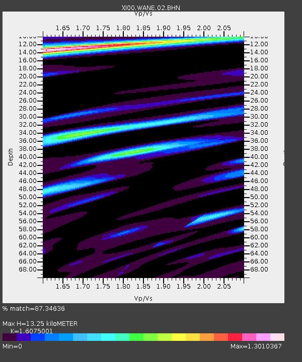
| Estimated Moho Depth: |
13.25 km |
| Estimated Crust Vp/Vs: |
1.61 |
| Assumed Crust Vp: |
6.375 km/s |
| Estimated Crust Vs: |
3.966 km/s |
| Estimated Crust Poisson's Ratio: |
0.18 |
|
| Radial Match: |
87.34636 % |
| Radial Bump: |
400 |
| Transverse Match: |
80.21039 % |
| Transverse Bump: |
400 |
| SOD ConfigId: |
16820 |
| Insert Time: |
2010-03-09 23:52:14.638 +0000 |
| GWidth: |
2.5 |
| Max Bumps: |
400 |
| Tol: |
0.001 |
|

Signal To Noise
| Channel | StoN | STA | LTA |
| XI:WANE:02:BHN:20011202T13:14:15.20302Z | 0.97839737 | 1.5085315E-7 | 1.5418394E-7 |
| XI:WANE:02:BHE:20011202T13:14:15.20302Z | 0.990133 | 2.0340049E-7 | 2.0542745E-7 |
| XI:WANE:02:BHZ:20011202T13:14:15.20302Z | 2.5761902 | 2.678986E-7 | 1.0399023E-7 |
| Arrivals |
| Ps | 1.3 SECOND |
| PpPs | 5.3 SECOND |
| PsPs/PpSs | 6.6 SECOND |


