You are here: Home > Network List > XM99 - Rio Grande Seismic Transect Stations List
> Station NM37 NewMexico37 > Earthquake Result Viewer
NM37 NewMexico37 - Earthquake Result Viewer
| Earthquake location: |
Fiji Islands Region |
| Earthquake latitude/longitude: |
-18.1/-176.9 |
| Earthquake time(UTC): |
2001/04/28 (118) 04:49:53 GMT |
| Earthquake Depth: |
352 km |
| Earthquake Magnitude: |
6.2 MB, 6.8 MW, 6.8 MW |
| Earthquake Catalog/Contributor: |
WHDF/NEIC |
|
| Network: |
XM Rio Grande Seismic Transect |
| Station: |
NM37 NewMexico37 |
| Lat/Lon: |
35.58 N/108.00 W |
| Elevation: |
2254 m |
|
| Distance: |
84.2 deg |
| Az: |
49.867 deg |
| Baz: |
243.156 deg |
| Ray Param: |
0.044694174 |
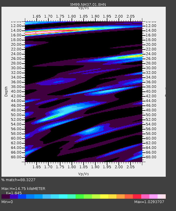
| Estimated Moho Depth: |
14.75 km |
| Estimated Crust Vp/Vs: |
1.64 |
| Assumed Crust Vp: |
6.496 km/s |
| Estimated Crust Vs: |
3.949 km/s |
| Estimated Crust Poisson's Ratio: |
0.21 |
|
| Radial Match: |
88.3227 % |
| Radial Bump: |
290 |
| Transverse Match: |
62.234573 % |
| Transverse Bump: |
400 |
| SOD ConfigId: |
4714 |
| Insert Time: |
2010-02-26 17:40:12.893 +0000 |
| GWidth: |
2.5 |
| Max Bumps: |
400 |
| Tol: |
0.001 |
|

Signal To Noise
| Channel | StoN | STA | LTA |
| XM:NM37:01:BHN:20010428T05:01:15.091011Z | 2.031116 | 2.6543717E-7 | 1.3068538E-7 |
| XM:NM37:01:BHE:20010428T05:01:15.091011Z | 2.4284992 | 3.236109E-7 | 1.3325551E-7 |
| XM:NM37:01:BHZ:20010428T05:01:15.091011Z | 11.054629 | 1.0775458E-6 | 9.747462E-8 |
| Arrivals |
| Ps | 1.5 SECOND |
| PpPs | 5.8 SECOND |
| PsPs/PpSs | 7.4 SECOND |


