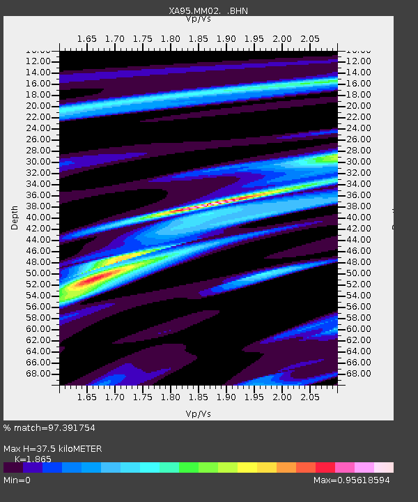
MM02 Hudson, New York - Earthquake Result Viewer
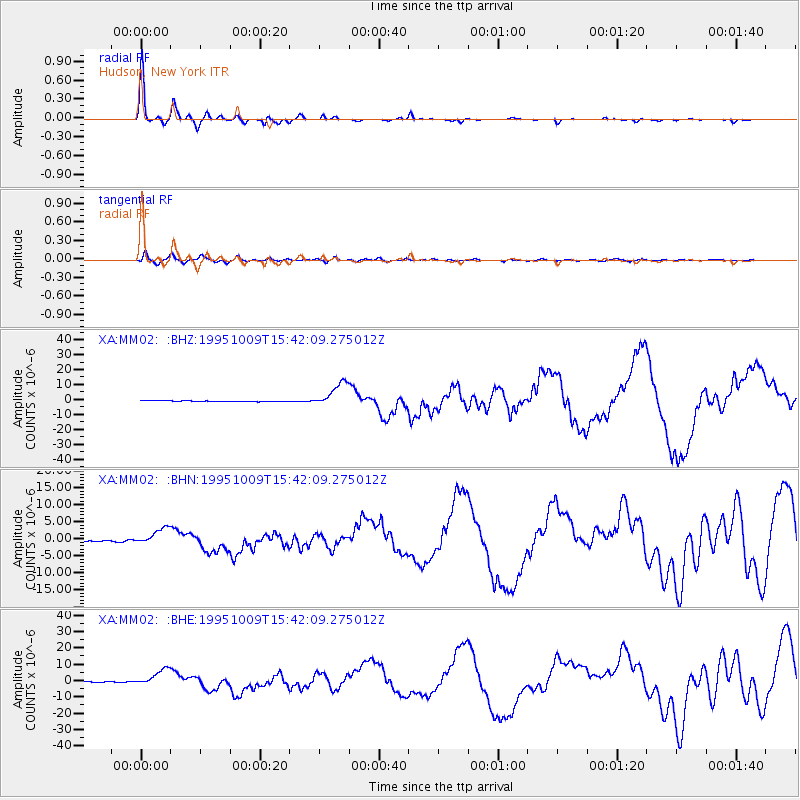
Earthquake location: Near Coast Of Jalisco, Mexico
Earthquake latitude/longitude: 19.1/-104.2
Earthquake time(UTC): 1995/10/09 (282) 15:35:55 GMT
Earthquake Depth: 49 km
Earthquake Magnitude: 6.5 MB, 7.3 MS, 7.3 UNKNOWN, 7.9 MW
Earthquake Catalog/Contributor: WHDF/NEIC
Network: XA Missouri to Massachusetts Transect
Station: MM02 Hudson, New York
Lat/Lon: 42.17 N/73.72 W
Elevation: 134 m
Distance: 34.6 deg
Az: 41.707 deg
Baz: 237.781 deg
Ray Param: 0.07756518
Estimated Moho Depth: 37.5 km
Estimated Crust Vp/Vs: 1.87
Assumed Crust Vp: 6.419 km/s
Estimated Crust Vs: 3.442 km/s
Estimated Crust Poisson's Ratio: 0.30
Radial Match: 97.391754 %
Radial Bump: 183
Transverse Match: 74.53514 %
Transverse Bump: 400
SOD ConfigId: 6273
Insert Time: 2010-02-26 17:43:01.670 +0000
GWidth: 2.5
Max Bumps: 400
Tol: 0.001

Signal To Noise

ChannelStoNSTALTA
XA:MM02: :BHN:19951009T15:42:09.275012Z11.7233252.5520396E-62.1768908E-7
XA:MM02: :BHE:19951009T15:42:09.275012Z15.238335.084124E-63.336405E-7
XA:MM02: :BHZ:19951009T15:42:09.275012Z36.453238.270248E-62.2687283E-7
Arrivals
Ps5.4 SECOND
PpPs16 SECOND
PsPs/PpSs21 SECOND