
Station XA MM02 - Hudson, New York
Network: XA95 - Missouri to Massachusetts Transect
Nearby stations (2 deg radius)
| Station | Name | (Lat, Lon) | Start / End | Elevation |
| MM02 | Hudson, New York | (42.17, -73.72) | 1995-02-04 / 1996-03-29 | 134 m |
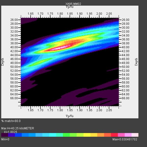
| Crust2 Type: | Q2,orogen/39km no ice, Appalachians, North Andes, 0.5 km seds. |
| Thickness Estimate: | 40 km |
| Thickness StdDev: | 2.0 km |
| Vp/Vs Estimate: | 1.80 |
| Vp/Vs StdDev: | 0.04 |
| Vs Estimate: | 3.561 km/s |
| Poisson's Ratio: | 0.28 |
| Peak Value: | 0.03 |
| Assumed Vp: | 6.419 km/s |
| Ps Weight: | 0.33333334 |
| PpPs Weight: | 0.33333334 |
| PsPs Weight: | 0.33333328 |
| Residual Complexity: | 0.669 |
| Nearby stations H: | +- |
| (2.0 deg) Vp/Vs: | +- |
17 with match > 90% ( 36.95652 %) and 27 with match > 80% ( 58.695652 %) out of 46.
Download stack as xyz text file.
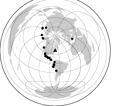
Azimuth Distribution of Events:
Prior Results for this Station
| Study | Thickness | Vp/Vs | Vp | Vs | Poissons Ratio | Extra |
| EARS | 40 km | 1.80 | 6.419 km/s | 3.561 km/s | 0.28 | |
| Crust2.0 | 39 km | 1.75 | 6.419 km/s | 3.659 km/s | 0.26 | Q2,orogen/39km no ice, Appalachians, North Andes, 0.5 km seds. |
| MOMA | 40 km | 1.80 | 6.6 km/s | 3.667 km/s | 0.28 | |
| MOMA | 41 km | 1.73 | 6.5 km/s | 3.757 km/s | 0.25 | |
| Global Maxima | 40 km | 1.80 | 6.419 km/s | 3.561 km/s | 0.28 | amp=0.030461702 |
| Local Maxima 1 | 37 km | 1.89 | 6.419 km/s | 3.401 km/s | 0.30 | amp=0.020506324 |
| Local Maxima 2 | 37 km | 1.80 | 6.419 km/s | 3.576 km/s | 0.27 | amp=0.014221294 |
| Local Maxima 3 | 51 km | 1.64 | 6.419 km/s | 3.92 km/s | 0.20 | amp=0.0106022 |
| Local Maxima 4 | 32 km | 1.92 | 6.419 km/s | 3.339 km/s | 0.31 | amp=0.010244285 |
| Predicted Arrivals for vertical incidence (zero ray parameter) | |
| Ps | 5.03 SECOND |
| PpPs | 17.57 SECOND |
| PsPs/PpSs | 22.60 SECOND |
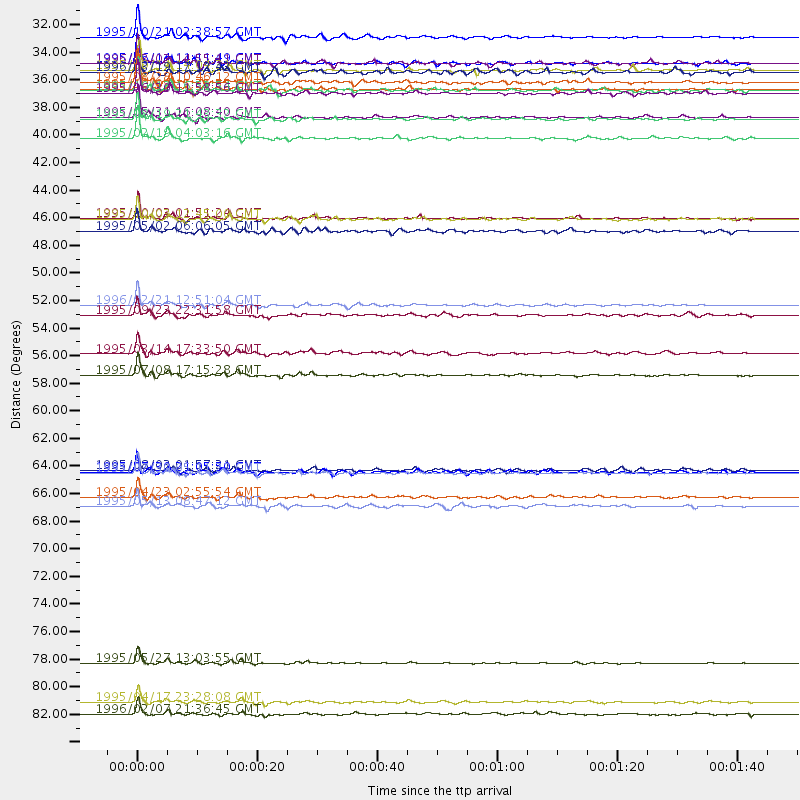
Events Processed for this Station
Download zip of receiver functions as SAC
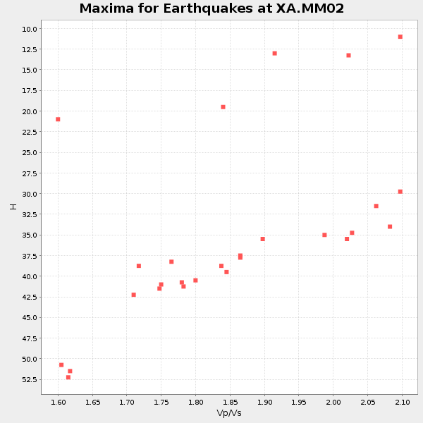
Plot maxima for each earthquake.
Events Used in the Stack
(27 events)| Radial Match | Distance | Baz | FERegion | Time | Lat/Lon | Depth | Magnitude |
| 98.54901 | 65.3 deg | 176.553 deg | Near Coast Of Northern Chile | 1995/07/30 05:11:23 GMT | (-23.4, -70.3) | 47 km | 6.6 MB, 7.3 MS, 7.2 UNKNOWN, 8.1 MW |
| 98.525635 | 80.5 deg | 338.38 deg | Sakhalin, Russia | 1995/05/27 13:03:55 GMT | (52.6, 142.8) | 33 km | 6.6 MB, 7.6 MS, 7.0 UNKNOWN, 7.0 MW |
| 97.75901 | 44.9 deg | 185.9 deg | Peru-Ecuador Border Region | 1995/10/03 01:51:24 GMT | (-2.8, -77.9) | 27 km | 6.5 MB, 7.0 MS, 6.9 UNKNOWN, 7.0 MW |
| 97.682816 | 51.8 deg | 187.346 deg | Off Coast Of Northern Peru | 1996/02/21 12:51:04 GMT | (-9.6, -79.6) | 33 km | 5.8 MB, 6.6 MS, 7.5 UNKNOWN, 7.3 MW |
| 97.391754 | 34.6 deg | 237.781 deg | Near Coast Of Jalisco, Mexico | 1995/10/09 15:35:55 GMT | (19.1, -104.2) | 49 km | 6.5 MB, 7.3 MS, 7.3 UNKNOWN, 7.9 MW |
| 96.83844 | 33.0 deg | 227.676 deg | Near Coast Of Guerrero, Mexico | 1995/09/14 14:04:31 GMT | (16.8, -98.6) | 21 km | 6.4 MB, 7.2 MS, 7.2 UNKNOWN, 7.5 MW |
| 95.98847 | 30.3 deg | 219.795 deg | Chiapas, Mexico | 1995/10/21 02:38:57 GMT | (16.9, -93.5) | 161 km | 6.2 MB, 7.3 UNKNOWN, 7.3 MW |
| 94.85752 | 32.5 deg | 207.394 deg | Off Coast Of Central America | 1995/06/14 11:11:49 GMT | (12.2, -88.3) | 39 km | 5.6 MB, 6.0 MS, 6.6 UNKNOWN |
| 94.7844 | 38.4 deg | 285.539 deg | Off Coast Of Northern California | 1995/02/19 04:03:16 GMT | (40.6, -125.5) | 10 km | 6.1 MB, 6.8 MS, 6.7 UNKNOWN, 6.6 MD |
| 94.46786 | 37.0 deg | 183.267 deg | Colombia | 1995/08/19 21:43:32 GMT | (5.1, -75.7) | 125 km | 6.1 MB, 6.6 UNKNOWN, 6.5 MW |
| 94.11129 | 57.4 deg | 315.037 deg | Unimak Island Region, Alaska | 1995/07/08 17:15:28 GMT | (53.6, -163.5) | 33 km | 5.8 MB, 5.7 MS, 5.5 UNKNOWN, 6.0 MW |
| 92.62897 | 34.0 deg | 253.74 deg | Gulf Of California | 1995/08/28 10:46:12 GMT | (26.2, -110.3) | 10 km | 5.6 MB, 6.5 MS |
| 92.19225 | 83.6 deg | 330.204 deg | Kuril Islands | 1995/04/17 23:28:08 GMT | (45.9, 151.3) | 34 km | 6.1 MB, 6.3 MS, 6.2 UNKNOWN, 6.8 MW |
| 91.77118 | 34.8 deg | 251.531 deg | Baja California, Mexico | 1995/06/30 11:58:56 GMT | (24.6, -110.3) | 10 km | 5.8 MB, 6.3 MS, 6.2 UNKNOWN |
| 91.74131 | 67.9 deg | 55.439 deg | Greece | 1995/05/13 08:47:12 GMT | (40.1, 21.7) | 13 km | 6.2 MB, 6.5 MS, 6.6 UNKNOWN, 6.5 MD |
| 91.32751 | 34.7 deg | 237.158 deg | Near Coast Of Jalisco, Mexico | 1995/10/12 16:52:54 GMT | (18.8, -104.0) | 25 km | 5.5 MB, 5.5 MS, 5.2 UNKNOWN, 6.0 MW |
| 91.06912 | 65.0 deg | 176.835 deg | Near Coast Of Northern Chile | 1995/08/03 01:57:21 GMT | (-23.1, -70.6) | 33 km | 5.4 MB, 5.9 MS, 5.7 UNKNOWN, 6.3 MW |
| 88.813866 | 67.2 deg | 319.286 deg | Rat Islands, Aleutian Islands | 1995/04/23 02:55:54 GMT | (51.3, 179.7) | 16 km | 6.1 MB, 6.4 MS, 6.5 UNKNOWN, 6.7 ML |
| 87.31792 | 84.6 deg | 330.727 deg | Kuril Islands | 1996/02/07 21:36:45 GMT | (45.3, 149.9) | 33 km | 6.3 MB, 7.0 MS, 7.2 UNKNOWN, 7.1 MW |
| 87.1896 | 65.2 deg | 176.832 deg | Near Coast Of Northern Chile | 1995/07/30 21:05:50 GMT | (-23.3, -70.6) | 33 km | 5.6 MB, 5.6 MS, 5.4 UNKNOWN, 6.1 MW |
| 87.02123 | 45.9 deg | 184.503 deg | Northern Peru | 1995/05/02 06:06:05 GMT | (-3.9, -77.0) | 103 km | 6.5 MB, 6.7 UNKNOWN, 6.6 MW |
| 86.941414 | 32.5 deg | 204.491 deg | Near Coast Of Nicaragua | 1996/03/03 14:55:11 GMT | (11.7, -86.9) | 33 km | 5.7 MB, 6.5 MS, 6.8 UNKNOWN, 6.4 MS |
| 86.599144 | 55.7 deg | 315.545 deg | Alaska Peninsula | 1995/03/14 17:33:50 GMT | (54.8, -161.3) | 33 km | 6.1 MB, 5.9 MS, 6.2 UNKNOWN, 5.5 ML |
| 84.25551 | 52.6 deg | 186.164 deg | Near Coast Of Peru | 1995/09/23 22:31:58 GMT | (-10.5, -78.7) | 73 km | 5.9 MB, 6.5 UNKNOWN, 6.4 MW |
| 83.26886 | 33.1 deg | 224.778 deg | Near Coast Of Oaxaca, Mexico | 1996/03/19 17:12:43 GMT | (15.9, -97.3) | 33 km | 5.8 MB, 5.2 MS |
| 81.70954 | 44.9 deg | 185.914 deg | Peru-Ecuador Border Region | 1995/10/03 12:45:00 GMT | (-2.8, -77.9) | 33 km | 6.0 MB, 6.1 MS, 5.9 UNKNOWN, 6.4 MW |
| 81.01104 | 36.8 deg | 241.389 deg | Off Coast Of Jalisco, Mexico | 1995/05/31 16:08:40 GMT | (18.9, -107.4) | 33 km | 5.4 MB, 6.1 MS, 6.3 UNKNOWN, 6.3 MW |
Losers
(19 events)| Radial Match | Distance | Baz | FERegion | Time | Lat/Lon | Depth | Magnitude | Reason |
| 95.984764 | 86.3 deg | 331.205 deg | Kuril Islands | 1995/04/28 17:08:43 GMT | (44.1, 148.1) | 33 km | 6.2 MB, 6.2 MS | |
| 79.346344 | 63.3 deg | 118.508 deg | Central Mid-Atlantic Ridge | 1995/05/18 00:06:26 GMT | (-0.9, -22.0) | 10 km | 6.2 MB, 6.1 MS, 6.8 UNKNOWN, 6.7 MW | |
| 78.7555 | 70.8 deg | 177.944 deg | Near Coast Of Central Chile | 1995/11/01 00:35:32 GMT | (-29.0, -71.5) | 20 km | 6.3 MB, 6.4 MS, 6.3 UNKNOWN, 6.7 MW | |
| 74.908936 | 67.7 deg | 319.629 deg | Rat Islands, Aleutian Islands | 1996/03/22 03:24:20 GMT | (51.2, 178.7) | 20 km | 5.7 MB, 6.6 MS, 6.8 UNKNOWN, 6.6 ML | |
| 74.53358 | 86.3 deg | 331.122 deg | Kuril Islands | 1995/04/19 03:50:05 GMT | (44.0, 148.2) | 33 km | 5.9 MB, 5.5 MS, 5.8 UNKNOWN, 5.7 MW | |
| 73.77396 | 65.1 deg | 176.812 deg | Near Coast Of Northern Chile | 1995/08/02 00:14:09 GMT | (-23.2, -70.6) | 33 km | 5.4 MB, 5.5 MS, 5.3 UNKNOWN | |
| 73.563545 | 70.3 deg | 175.768 deg | Chile-Argentina Border Region | 1995/08/03 08:18:53 GMT | (-28.3, -69.2) | 104 km | 5.9 MB, 5.8 UNKNOWN, 5.9 MW | |
| 73.12405 | 91.9 deg | 332.243 deg | Off East Coast Of Honshu, Japan | 1995/07/08 05:42:56 GMT | (39.6, 143.4) | 40 km | 5.7 MB, 5.5 MS, 5.2 UNKNOWN, 6.0 MW | |
| 72.3305 | 75.4 deg | 329.601 deg | Off East Coast Of Kamchatka | 1995/04/01 05:50:20 GMT | (52.3, 159.1) | 47 km | 5.9 MB, 5.6 MS, 5.3 UNKNOWN, 6.0 MW | |
| 69.83516 | 86.3 deg | 331.231 deg | Kuril Islands | 1995/04/28 16:30:00 GMT | (44.1, 148.1) | 29 km | 6.6 MB, 6.9 MS, 7.0 UNKNOWN, 6.8 MW | |
| 68.86431 | 43.2 deg | 187.335 deg | Ecuador | 1996/03/28 23:03:49 GMT | (-1.0, -78.7) | 33 km | 5.8 MB, 5.2 MS, 5.9 UNKNOWN, 5.1 MS | |
| 67.42327 | 74.3 deg | 52.696 deg | Turkey | 1995/10/01 15:57:16 GMT | (38.1, 30.2) | 33 km | 5.7 MB, 6.1 MS, 6.3 UNKNOWN, 6.0 MW | |
| 65.72532 | 80.0 deg | 329.967 deg | Kuril Islands | 1995/06/29 07:45:09 GMT | (48.8, 154.5) | 62 km | 5.9 MB, 6.0 UNKNOWN, 6.0 MW | |
| 62.152565 | 82.7 deg | 206.261 deg | Southern East Pacific Rise | 1995/10/12 23:41:45 GMT | (-35.4, -106.2) | 10 km | 5.5 MB, 5.3 MS, 5.9 UNKNOWN | |
| 62.041237 | 77.6 deg | 53.862 deg | Cyprus Region | 1995/02/23 21:03:02 GMT | (35.0, 32.3) | 15 km | 5.8 MB, 5.7 MS, 5.9 UNKNOWN, 5.8 MW | |
| 61.37382 | 86.3 deg | 332.728 deg | Kuril Islands | 1996/02/01 07:18:05 GMT | (44.9, 146.3) | 180 km | 5.7 MB, 6.2 UNKNOWN, 6.2 MW | |
| 59.279724 | 84.8 deg | 333.838 deg | Sea Of Okhotsk | 1995/02/18 13:29:06 GMT | (46.7, 145.9) | 355 km | 5.6 MB, 5.7 UNKNOWN, 5.5 MW | |
| 47.477978 | 63.6 deg | 316.745 deg | Andreanof Islands, Aleutian Is. | 1995/10/30 20:25:28 GMT | (51.7, -173.4) | 33 km | 5.4 MB, 5.3 MS, 5.8 UNKNOWN, 5.6 ML | |
| 46.90983 | 77.2 deg | 329.596 deg | Kuril Islands | 1995/09/30 10:47:56 GMT | (50.8, 157.4) | 33 km | 5.7 MB, 5.5 MS |
