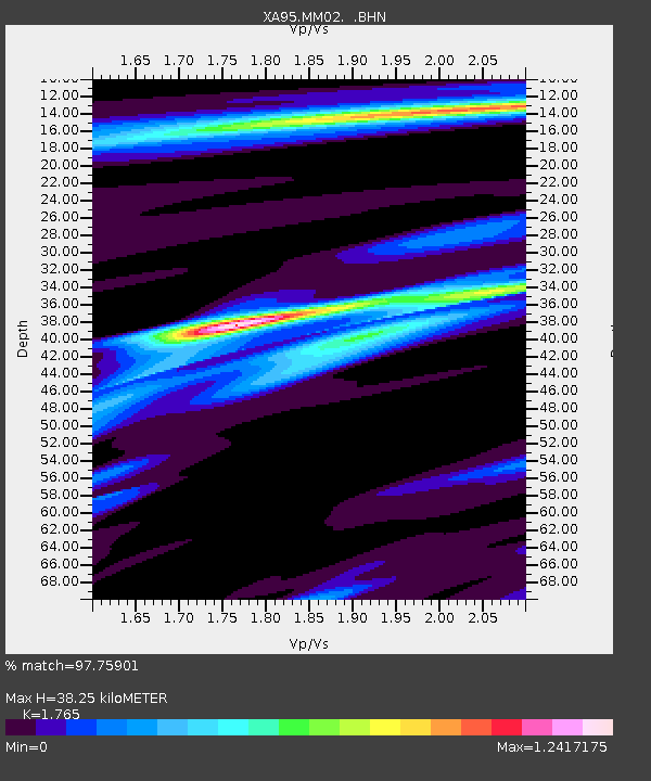
MM02 Hudson, New York - Earthquake Result Viewer
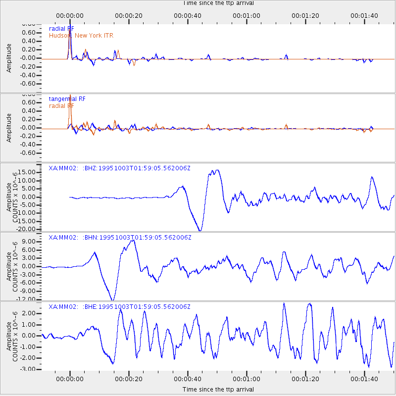
Earthquake location: Peru-Ecuador Border Region
Earthquake latitude/longitude: -2.8/-77.9
Earthquake time(UTC): 1995/10/03 (276) 01:51:24 GMT
Earthquake Depth: 27 km
Earthquake Magnitude: 6.5 MB, 7.0 MS, 6.9 UNKNOWN, 7.0 MW
Earthquake Catalog/Contributor: WHDF/NEIC
Network: XA Missouri to Massachusetts Transect
Station: MM02 Hudson, New York
Lat/Lon: 42.17 N/73.72 W
Elevation: 134 m
Distance: 44.9 deg
Az: 4.388 deg
Baz: 185.9 deg
Ray Param: 0.071590915
Estimated Moho Depth: 38.25 km
Estimated Crust Vp/Vs: 1.76
Assumed Crust Vp: 6.419 km/s
Estimated Crust Vs: 3.637 km/s
Estimated Crust Poisson's Ratio: 0.26
Radial Match: 97.75901 %
Radial Bump: 249
Transverse Match: 89.03411 %
Transverse Bump: 400
SOD ConfigId: 6273
Insert Time: 2010-02-26 17:43:03.364 +0000
GWidth: 2.5
Max Bumps: 400
Tol: 0.001

Signal To Noise

ChannelStoNSTALTA
XA:MM02: :BHN:19951003T01:59:05.562006Z3.07243563.7825447E-71.2311224E-7
XA:MM02: :BHE:19951003T01:59:05.562006Z0.97701481.8008812E-71.8432486E-7
XA:MM02: :BHZ:19951003T01:59:05.562006Z2.49355245.6946845E-72.2837636E-7
Arrivals
Ps4.9 SECOND
PpPs15 SECOND
PsPs/PpSs20 SECOND