You are here: Home > Network List > XA95 - Missouri to Massachusetts Transect Stations List
> Station MM02 Hudson, New York > Earthquake Result Viewer
MM02 Hudson, New York - Earthquake Result Viewer
| Earthquake location: |
Baja California, Mexico |
| Earthquake latitude/longitude: |
24.6/-110.3 |
| Earthquake time(UTC): |
1995/06/30 (181) 11:58:56 GMT |
| Earthquake Depth: |
10 km |
| Earthquake Magnitude: |
5.8 MB, 6.3 MS, 6.2 UNKNOWN |
| Earthquake Catalog/Contributor: |
WHDF/NEIC |
|
| Network: |
XA Missouri to Massachusetts Transect |
| Station: |
MM02 Hudson, New York |
| Lat/Lon: |
42.17 N/73.72 W |
| Elevation: |
134 m |
|
| Distance: |
34.8 deg |
| Az: |
50.784 deg |
| Baz: |
251.531 deg |
| Ray Param: |
0.07753051 |
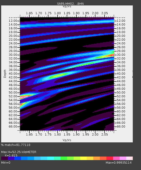
| Estimated Moho Depth: |
52.25 km |
| Estimated Crust Vp/Vs: |
1.62 |
| Assumed Crust Vp: |
6.419 km/s |
| Estimated Crust Vs: |
3.975 km/s |
| Estimated Crust Poisson's Ratio: |
0.19 |
|
| Radial Match: |
91.77118 % |
| Radial Bump: |
269 |
| Transverse Match: |
75.90318 % |
| Transverse Bump: |
400 |
| SOD ConfigId: |
6273 |
| Insert Time: |
2010-02-26 17:43:07.718 +0000 |
| GWidth: |
2.5 |
| Max Bumps: |
400 |
| Tol: |
0.001 |
|

Signal To Noise
| Channel | StoN | STA | LTA |
| XA:MM02: :BHN:19950630T12:05:16.772009Z | 1.0738938 | 1.0267394E-7 | 9.5609025E-8 |
| XA:MM02: :BHE:19950630T12:05:16.772009Z | 2.9750538 | 3.4111383E-7 | 1.14658036E-7 |
| XA:MM02: :BHZ:19950630T12:05:16.772009Z | 4.2317 | 5.139782E-7 | 1.2145902E-7 |
| Arrivals |
| Ps | 5.4 SECOND |
| PpPs | 20 SECOND |
| PsPs/PpSs | 25 SECOND |


