You are here: Home > Network List > XA95 - Missouri to Massachusetts Transect Stations List
> Station MM02 Hudson, New York > Earthquake Result Viewer
MM02 Hudson, New York - Earthquake Result Viewer
| Earthquake location: |
Alaska Peninsula |
| Earthquake latitude/longitude: |
54.8/-161.3 |
| Earthquake time(UTC): |
1995/03/14 (073) 17:33:50 GMT |
| Earthquake Depth: |
33 km |
| Earthquake Magnitude: |
6.1 MB, 5.9 MS, 6.2 UNKNOWN, 5.5 ML |
| Earthquake Catalog/Contributor: |
WHDF/NEIC |
|
| Network: |
XA Missouri to Massachusetts Transect |
| Station: |
MM02 Hudson, New York |
| Lat/Lon: |
42.17 N/73.72 W |
| Elevation: |
134 m |
|
| Distance: |
55.7 deg |
| Az: |
64.037 deg |
| Baz: |
315.545 deg |
| Ray Param: |
0.06455954 |
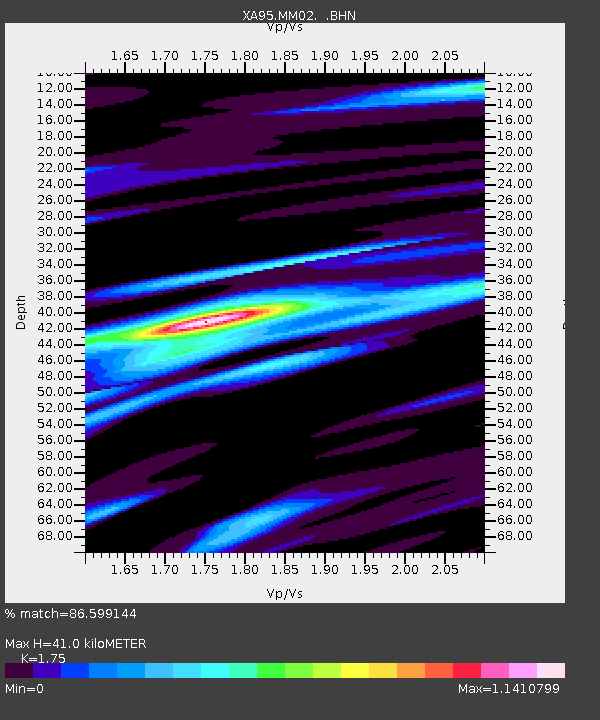
| Estimated Moho Depth: |
41.0 km |
| Estimated Crust Vp/Vs: |
1.75 |
| Assumed Crust Vp: |
6.419 km/s |
| Estimated Crust Vs: |
3.668 km/s |
| Estimated Crust Poisson's Ratio: |
0.26 |
|
| Radial Match: |
86.599144 % |
| Radial Bump: |
392 |
| Transverse Match: |
73.323166 % |
| Transverse Bump: |
400 |
| SOD ConfigId: |
6273 |
| Insert Time: |
2010-02-26 17:43:12.571 +0000 |
| GWidth: |
2.5 |
| Max Bumps: |
400 |
| Tol: |
0.001 |
|
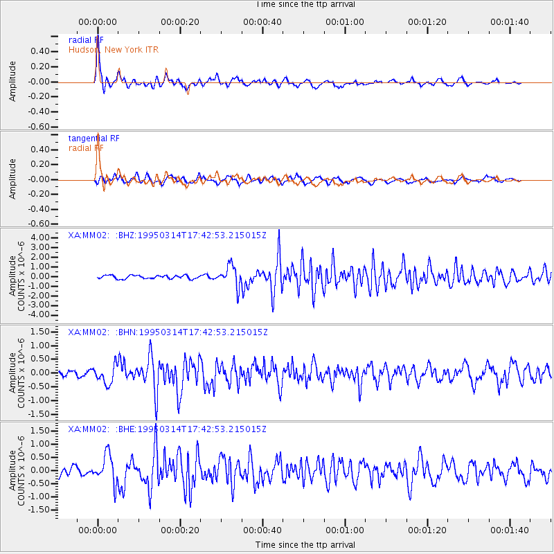
Signal To Noise
| Channel | StoN | STA | LTA |
| XA:MM02: :BHN:19950314T17:42:53.215015Z | 2.505888 | 3.3951247E-7 | 1.3548589E-7 |
| XA:MM02: :BHE:19950314T17:42:53.215015Z | 3.0671804 | 5.58356E-7 | 1.8204211E-7 |
| XA:MM02: :BHZ:19950314T17:42:53.215015Z | 6.3280745 | 1.111358E-6 | 1.756234E-7 |
| Arrivals |
| Ps | 5.0 SECOND |
| PpPs | 17 SECOND |
| PsPs/PpSs | 22 SECOND |


