You are here: Home > Network List > XA95 - Missouri to Massachusetts Transect Stations List
> Station MM02 Hudson, New York > Earthquake Result Viewer
MM02 Hudson, New York - Earthquake Result Viewer
| Earthquake location: |
Gulf Of California |
| Earthquake latitude/longitude: |
26.2/-110.3 |
| Earthquake time(UTC): |
1995/08/28 (240) 10:46:12 GMT |
| Earthquake Depth: |
10 km |
| Earthquake Magnitude: |
5.6 MB, 6.5 MS |
| Earthquake Catalog/Contributor: |
WHDF/NEIC |
|
| Network: |
XA Missouri to Massachusetts Transect |
| Station: |
MM02 Hudson, New York |
| Lat/Lon: |
42.17 N/73.72 W |
| Elevation: |
134 m |
|
| Distance: |
34.0 deg |
| Az: |
52.571 deg |
| Baz: |
253.74 deg |
| Ray Param: |
0.07796831 |
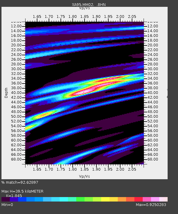
| Estimated Moho Depth: |
39.5 km |
| Estimated Crust Vp/Vs: |
1.85 |
| Assumed Crust Vp: |
6.419 km/s |
| Estimated Crust Vs: |
3.479 km/s |
| Estimated Crust Poisson's Ratio: |
0.29 |
|
| Radial Match: |
92.62897 % |
| Radial Bump: |
319 |
| Transverse Match: |
61.868042 % |
| Transverse Bump: |
400 |
| SOD ConfigId: |
6273 |
| Insert Time: |
2010-02-26 17:43:23.653 +0000 |
| GWidth: |
2.5 |
| Max Bumps: |
400 |
| Tol: |
0.001 |
|
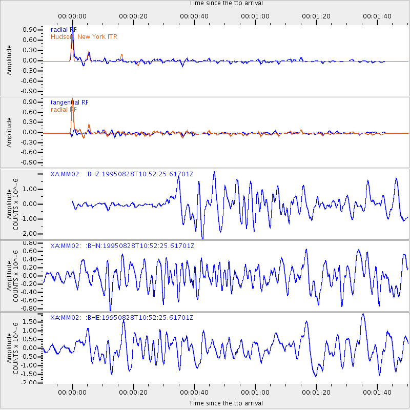
Signal To Noise
| Channel | StoN | STA | LTA |
| XA:MM02: :BHN:19950828T10:52:25.61701Z | 2.2006218 | 2.2123291E-7 | 1.0053199E-7 |
| XA:MM02: :BHE:19950828T10:52:25.61701Z | 3.7462893 | 4.2084193E-7 | 1.1233568E-7 |
| XA:MM02: :BHZ:19950828T10:52:25.61701Z | 6.059614 | 6.495894E-7 | 1.071998E-7 |
| Arrivals |
| Ps | 5.6 SECOND |
| PpPs | 16 SECOND |
| PsPs/PpSs | 22 SECOND |


