You are here: Home > Network List > XA95 - Missouri to Massachusetts Transect Stations List
> Station MM02 Hudson, New York > Earthquake Result Viewer
MM02 Hudson, New York - Earthquake Result Viewer
| Earthquake location: |
Near Coast Of Peru |
| Earthquake latitude/longitude: |
-10.5/-78.7 |
| Earthquake time(UTC): |
1995/09/23 (266) 22:31:58 GMT |
| Earthquake Depth: |
73 km |
| Earthquake Magnitude: |
5.9 MB, 6.5 UNKNOWN, 6.4 MW |
| Earthquake Catalog/Contributor: |
WHDF/NEIC |
|
| Network: |
XA Missouri to Massachusetts Transect |
| Station: |
MM02 Hudson, New York |
| Lat/Lon: |
42.17 N/73.72 W |
| Elevation: |
134 m |
|
| Distance: |
52.6 deg |
| Az: |
4.656 deg |
| Baz: |
186.164 deg |
| Ray Param: |
0.06642248 |
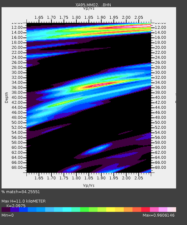
| Estimated Moho Depth: |
11.0 km |
| Estimated Crust Vp/Vs: |
2.10 |
| Assumed Crust Vp: |
6.419 km/s |
| Estimated Crust Vs: |
3.06 km/s |
| Estimated Crust Poisson's Ratio: |
0.35 |
|
| Radial Match: |
84.25551 % |
| Radial Bump: |
342 |
| Transverse Match: |
76.24111 % |
| Transverse Bump: |
400 |
| SOD ConfigId: |
6273 |
| Insert Time: |
2010-02-26 17:43:25.829 +0000 |
| GWidth: |
2.5 |
| Max Bumps: |
400 |
| Tol: |
0.001 |
|

Signal To Noise
| Channel | StoN | STA | LTA |
| XA:MM02: :BHN:19950923T22:40:34.33302Z | 3.9524364 | 7.428554E-7 | 1.8794871E-7 |
| XA:MM02: :BHE:19950923T22:40:34.33302Z | 0.6697046 | 2.2371339E-7 | 3.3404785E-7 |
| XA:MM02: :BHZ:19950923T22:40:34.33302Z | 3.1259239 | 1.2467146E-6 | 3.988308E-7 |
| Arrivals |
| Ps | 2.0 SECOND |
| PpPs | 5.1 SECOND |
| PsPs/PpSs | 7.0 SECOND |


