You are here: Home > Network List > AU - Australian Seismological Centre Stations List
> Station KIM06 GSWA station > Earthquake Result Viewer
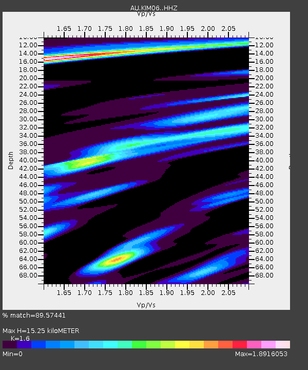
KIM06 GSWA station - Earthquake Result Viewer
| Earthquake location: |
Taiwan |
| Earthquake latitude/longitude: |
23.1/121.3 |
| Earthquake time(UTC): |
2022/09/18 (261) 06:44:15 GMT |
| Earthquake Depth: |
10 km |
| Earthquake Magnitude: |
7.2 Mi |
| Earthquake Catalog/Contributor: |
NEIC PDE/at |
|
| Network: |
AU Australian Seismological Centre |
| Station: |
KIM06 GSWA station |
| Lat/Lon: |
18.51 S/123.46 E |
| Elevation: |
134 m |
|
| Distance: |
41.4 deg |
| Az: |
176.905 deg |
| Baz: |
356.997 deg |
| Ray Param: |
0.073814616 |
| Estimated Moho Depth: |
15.25 km |
| Estimated Crust Vp/Vs: |
1.60 |
| Assumed Crust Vp: |
6.347 km/s |
| Estimated Crust Vs: |
3.967 km/s |
| Estimated Crust Poisson's Ratio: |
0.18 |
|
| Radial Match: |
89.57441 % |
| Radial Bump: |
346 |
| Transverse Match: |
71.099754 % |
| Transverse Bump: |
400 |
| SOD ConfigId: |
28764291 |
| Insert Time: |
2022-10-02 06:51:55.513 +0000 |
| GWidth: |
2.5 |
| Max Bumps: |
400 |
| Tol: |
0.001 |
|

Signal To Noise
| Channel | StoN | STA | LTA |
| AU:KIM06: :HHZ:20220918T06:51:30.545013Z | 2.9399245 | 6.702378E-7 | 2.2797789E-7 |
| AU:KIM06: :HHN:20220918T06:51:30.545013Z | 1.2792606 | 4.3219495E-7 | 3.3784747E-7 |
| AU:KIM06: :HHE:20220918T06:51:30.545013Z | 0.99673873 | 2.7879315E-7 | 2.7970535E-7 |
| Arrivals |
| Ps | 1.6 SECOND |
| PpPs | 5.8 SECOND |
| PsPs/PpSs | 7.4 SECOND |


