
Station AU KIM06 - GSWA station
Network: AU - Australian Seismological Centre
Nearby stations (2 deg radius)
| Station | Name | (Lat, Lon) | Start / End | Elevation |
| KIM06 | GSWA station | (-18.51, 123.46) | 2021-09-19 / 2499-01-01 | 134 m |
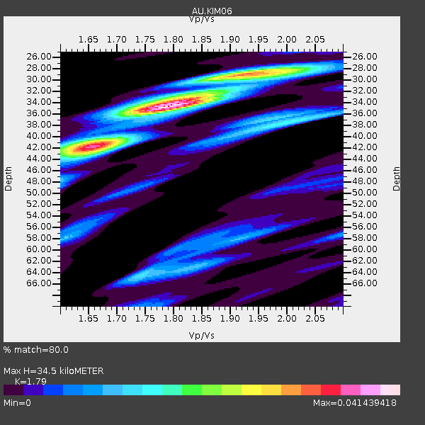
| Crust2 Type: | IL,thin late Proter., 3.5 km seds. |
| Thickness Estimate: | 34 km |
| Thickness StdDev: | 7.0 km |
| Vp/Vs Estimate: | 1.79 |
| Vp/Vs StdDev: | 0.08 |
| Vs Estimate: | 3.546 km/s |
| Poisson's Ratio: | 0.27 |
| Peak Value: | 0.04 |
| Assumed Vp: | 6.347 km/s |
| Ps Weight: | 0.33333334 |
| PpPs Weight: | 0.33333334 |
| PsPs Weight: | 0.33333328 |
| Residual Complexity: | 0.656 |
| Nearby stations H: | +- |
| (2.0 deg) Vp/Vs: | +- |
3 with match > 90% ( 8.571428 %) and 9 with match > 80% ( 25.714285 %) out of 35.
Download stack as xyz text file.
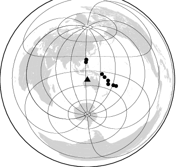
Azimuth Distribution of Events:
Prior Results for this Station
| Study | Thickness | Vp/Vs | Vp | Vs | Poissons Ratio | Extra |
| EARS | 34 km | 1.79 | 6.347 km/s | 3.546 km/s | 0.27 | |
| Crust2.0 | 34 km | 1.78 | 6.347 km/s | 3.568 km/s | 0.27 | IL,thin late Proter., 3.5 km seds. |
| Global Maxima | 34 km | 1.79 | 6.347 km/s | 3.546 km/s | 0.27 | amp=0.041439418 |
| Local Maxima 1 | 42 km | 1.65 | 6.347 km/s | 3.847 km/s | 0.21 | amp=0.028054237 |
| Local Maxima 2 | 29 km | 1.93 | 6.347 km/s | 3.284 km/s | 0.32 | amp=0.024884 |
| Local Maxima 3 | 64 km | 1.75 | 6.347 km/s | 3.637 km/s | 0.26 | amp=0.014577856 |
| Local Maxima 4 | 58 km | 1.61 | 6.347 km/s | 3.948 km/s | 0.18 | amp=0.013162846 |
| Predicted Arrivals for vertical incidence (zero ray parameter) | |
| Ps | 4.29 SECOND |
| PpPs | 15.17 SECOND |
| PsPs/PpSs | 19.46 SECOND |
Events Processed for this Station
Download zip of receiver functions as SAC
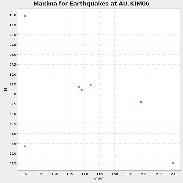
Plot maxima for each earthquake.
Events Used in the Stack
(9 events)| Radial Match | Distance | Baz | FERegion | Time | Lat/Lon | Depth | Magnitude |
| 95.296165 | 60.6 deg | 102.155 deg | Tonga Islands Region | 2022/11/11 10:48:45 UTC | (-19.3, -172.1) | 25 km | 7.3 Mww |
| 93.14105 | 36.0 deg | 81.149 deg | Solomon Islands | 2022/11/22 02:03:07 UTC | (-9.8, 159.6) | 14 km | 7.0 Mww |
| 90.62782 | 43.8 deg | 101.581 deg | Southeast Of Loyalty Islands | 2022/09/14 11:04:07 UTC | (-21.2, 170.1) | 124 km | 7.0 Mi |
| 89.823326 | 42.7 deg | 92.232 deg | Vanuatu Islands | 2023/11/22 04:47:31 UTC | (-15.0, 168.0) | 13 km | 6.7 mww |
| 89.57441 | 41.4 deg | 356.997 deg | Taiwan | 2022/09/18 06:44:15 UTC | (23.1, 121.3) | 10 km | 7.2 Mi |
| 89.04382 | 36.3 deg | 355.438 deg | Luzon, Philippines | 2022/10/25 14:59:04 UTC | (17.9, 120.6) | 10 km | 6.8 Mi |
| 86.43082 | 41.3 deg | 356.85 deg | Taiwan | 2022/09/17 13:41:21 UTC | (23.0, 121.2) | 45 km | 6.6 Mi |
| 84.33776 | 54.7 deg | 101.888 deg | Fiji Islands Region | 2022/11/12 07:09:14 UTC | (-20.1, -178.4) | 587 km | 7.0 mww |
| 81.30014 | 32.4 deg | 68.862 deg | New Ireland Region, P.N.G. | 2022/10/13 22:20:20 UTC | (-4.8, 153.6) | 71 km | 6.4 mww |
Losers
(26 events)| Radial Match | Distance | Baz | FERegion | Time | Lat/Lon | Depth | Magnitude | Reason |
| 98.58175 | 38.3 deg | 287.543 deg | South Indian Ocean | 2023/11/14 07:00:56 UTC | (-4.0, 87.1) | 10 km | 6.1 mww | |
| 78.849815 | 29.9 deg | 4.856 deg | Samar, Philippines | 2023/11/02 06:50:26 UTC | (11.5, 125.9) | 19 km | 5.7 Mww | |
| 78.68085 | 53.7 deg | 14.274 deg | Near S. Coast Of Honshu, Japan | 2022/11/14 08:08:26 UTC | (33.8, 137.3) | 357 km | 6.1 mww | |
| 78.24134 | 51.1 deg | 108.746 deg | South Of Fiji Islands | 2022/11/09 09:38:42 UTC | (-26.0, 178.4) | 629 km | 6.8 mww | |
| 75.27236 | 52.0 deg | 96.672 deg | Fiji Islands | 2022/10/09 22:58:50 UTC | (-16.4, 178.1) | 10 km | 5.5 Mww | |
| 74.416374 | 52.1 deg | 336.539 deg | Sichuan, China | 2022/09/05 04:52:19 UTC | (29.7, 102.3) | 10 km | 6.6 mww | |
| 70.84799 | 49.8 deg | 324.857 deg | Myanmar-India Border Region | 2022/09/29 22:22:38 UTC | (23.1, 94.9) | 165 km | 5.6 mww | |
| 69.01674 | 42.9 deg | 31.187 deg | Mariana Islands | 2023/11/19 04:01:36 UTC | (18.8, 145.3) | 598 km | 5.9 mww | |
| 69.00737 | 68.8 deg | 20.266 deg | Kuril Islands | 2023/11/10 10:10:04 UTC | (45.9, 151.0) | 107 km | 5.8 mww | |
| 66.925995 | 50.9 deg | 108.832 deg | South Of Fiji Islands | 2022/11/14 05:04:11 UTC | (-26.0, 178.2) | 627 km | 6.1 mww | |
| 63.58782 | 36.2 deg | 81.232 deg | Solomon Islands | 2022/11/25 13:46:51 UTC | (-9.8, 159.8) | 10 km | 5.7 mww | |
| 63.507298 | 61.9 deg | 16.006 deg | Hokkaido, Japan Region | 2023/11/19 21:01:31 UTC | (41.2, 142.2) | 53 km | 6.0 Mww | |
| 61.7693 | 42.3 deg | 96.484 deg | Vanuatu Islands | 2023/11/11 12:35:30 UTC | (-17.9, 168.1) | 24 km | 5.5 mww | |
| 61.365196 | 95.8 deg | 197.177 deg | East Of South Sandwich Islands | 2022/09/29 03:03:29 UTC | (-60.6, -20.0) | 33 km | 6.7 Mi | |
| 60.758827 | 42.8 deg | 31.236 deg | Mariana Islands | 2023/11/07 18:15:34 UTC | (18.8, 145.3) | 623 km | 5.6 mww | |
| 60.004128 | 61.7 deg | 318.946 deg | Nepal | 2023/11/03 18:02:54 UTC | (28.9, 82.2) | 18 km | 5.6 Mww | |
| 59.414055 | 53.2 deg | 117.353 deg | South Of Kermadec Islands | 2022/08/29 18:10:50 UTC | (-32.7, -179.1) | 32 km | 5.8 mww | |
| 57.438255 | 62.6 deg | 318.56 deg | Nepal | 2022/11/08 20:27:23 UTC | (29.3, 81.2) | 16 km | 5.6 mww | |
| 55.840904 | 87.0 deg | 215.469 deg | Southwest Of Africa | 2022/11/19 00:49:37 UTC | (-52.2, 13.8) | 10 km | 5.5 mww | |
| 55.13535 | 63.2 deg | 332.603 deg | Qinghai, China | 2022/10/19 04:35:35 UTC | (37.7, 92.3) | 8.6 km | 5.5 Mww | |
| 50.870754 | 52.9 deg | 117.2 deg | South Of Kermadec Islands | 2023/11/14 07:46:02 UTC | (-32.6, -179.4) | 77 km | 5.4 Mww | |
| 46.690987 | 43.2 deg | 100.409 deg | Vanuatu Islands | 2023/11/05 15:29:17 UTC | (-20.4, 169.4) | 32 km | 5.7 Mww | |
| 46.31334 | 42.1 deg | 87.117 deg | Santa Cruz Islands | 2022/11/16 22:26:52 UTC | (-11.7, 166.6) | 138 km | 5.8 mww | |
| 44.71234 | 84.9 deg | 146.725 deg | Pacific-Antarctic Ridge | 2022/11/27 14:04:10 UTC | (-55.1, -128.5) | 10 km | 5.5 Mww | |
| 38.57188 | 52.6 deg | 114.871 deg | Kermadec Islands Region | 2023/11/13 14:40:55 UTC | (-30.7, -179.7) | 435 km | 5.7 Mww | |
| 22.079035 | 54.5 deg | 328.248 deg | Eastern Xizang-India Border Reg. | 2022/11/10 05:01:07 UTC | (28.4, 94.4) | 21 km | 5.4 mww |

