You are here: Home > Network List > GS - US Geological Survey Networks Stations List
> Station NE01 NE01 Arnold Nebraska > Earthquake Result Viewer
NE01 NE01 Arnold Nebraska - Earthquake Result Viewer
| Earthquake location: |
Ecuador |
| Earthquake latitude/longitude: |
-2.3/-78.9 |
| Earthquake time(UTC): |
2018/09/07 (250) 02:12:04 GMT |
| Earthquake Depth: |
94 km |
| Earthquake Magnitude: |
6.2 Mww |
| Earthquake Catalog/Contributor: |
NEIC PDE/us |
|
| Network: |
GS US Geological Survey Networks |
| Station: |
NE01 NE01 Arnold Nebraska |
| Lat/Lon: |
41.42 N/100.19 W |
| Elevation: |
829 m |
|
| Distance: |
47.7 deg |
| Az: |
338.316 deg |
| Baz: |
150.604 deg |
| Ray Param: |
0.06954721 |
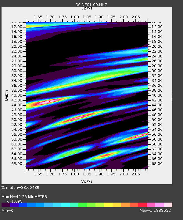
| Estimated Moho Depth: |
42.25 km |
| Estimated Crust Vp/Vs: |
1.70 |
| Assumed Crust Vp: |
6.483 km/s |
| Estimated Crust Vs: |
3.825 km/s |
| Estimated Crust Poisson's Ratio: |
0.23 |
|
| Radial Match: |
88.60489 % |
| Radial Bump: |
400 |
| Transverse Match: |
74.30329 % |
| Transverse Bump: |
400 |
| SOD ConfigId: |
2825771 |
| Insert Time: |
2018-09-21 02:27:33.984 +0000 |
| GWidth: |
2.5 |
| Max Bumps: |
400 |
| Tol: |
0.001 |
|

Signal To Noise
| Channel | StoN | STA | LTA |
| GS:NE01:00:HHZ:20180907T02:20:00.818994Z | 24.544685 | 5.7924844E-6 | 2.3599749E-7 |
| GS:NE01:00:HH1:20180907T02:20:00.818994Z | 13.855946 | 4.854613E-6 | 3.5036317E-7 |
| GS:NE01:00:HH2:20180907T02:20:00.818994Z | 9.440998 | 3.0799476E-6 | 3.2623117E-7 |
| Arrivals |
| Ps | 4.8 SECOND |
| PpPs | 16 SECOND |
| PsPs/PpSs | 21 SECOND |


