You are here: Home > Network List > AU - Australian Seismological Centre Stations List
> Station KIM10 GSWA station > Earthquake Result Viewer
KIM10 GSWA station - Earthquake Result Viewer
| Earthquake location: |
East Of South Sandwich Islands |
| Earthquake latitude/longitude: |
-60.6/-20.0 |
| Earthquake time(UTC): |
2022/09/29 (272) 03:03:29 GMT |
| Earthquake Depth: |
33 km |
| Earthquake Magnitude: |
6.7 Mi |
| Earthquake Catalog/Contributor: |
NEIC PDE/at |
|
| Network: |
AU Australian Seismological Centre |
| Station: |
KIM10 GSWA station |
| Lat/Lon: |
17.05 S/125.70 E |
| Elevation: |
312 m |
|
| Distance: |
97.8 deg |
| Az: |
147.037 deg |
| Baz: |
196.299 deg |
| Ray Param: |
0.040074598 |
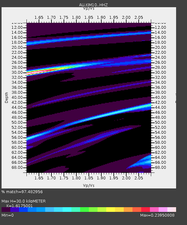
| Estimated Moho Depth: |
30.0 km |
| Estimated Crust Vp/Vs: |
1.62 |
| Assumed Crust Vp: |
6.496 km/s |
| Estimated Crust Vs: |
4.016 km/s |
| Estimated Crust Poisson's Ratio: |
0.19 |
|
| Radial Match: |
97.482956 % |
| Radial Bump: |
69 |
| Transverse Match: |
97.48296 % |
| Transverse Bump: |
69 |
| SOD ConfigId: |
28764291 |
| Insert Time: |
2022-10-13 03:06:47.238 +0000 |
| GWidth: |
2.5 |
| Max Bumps: |
400 |
| Tol: |
0.001 |
|

Signal To Noise
| Channel | StoN | STA | LTA |
| AU:KIM10: :HHZ:20220929T03:16:29.599976Z | 4.1049385 | 9.887658E-7 | 2.4087228E-7 |
| AU:KIM10: :HHN:20220929T03:16:29.599976Z | 3.7353015 | 1.2109814E-6 | 3.241991E-7 |
| $trig.getChannelId() | $trig.getValue() | $trig.getSTA() | $trig.getLTA() |
| Arrivals |
| Ps | 2.9 SECOND |
| PpPs | 12 SECOND |
| PsPs/PpSs | 15 SECOND |


