
Station AU KIM10 - GSWA station
Network: AU - Australian Seismological Centre
Nearby stations (2 deg radius)
| Station | Name | (Lat, Lon) | Start / End | Elevation |
| KIM10 | GSWA station | (-17.05, 125.70) | 2021-09-24 / 2499-01-01 | 312 m |
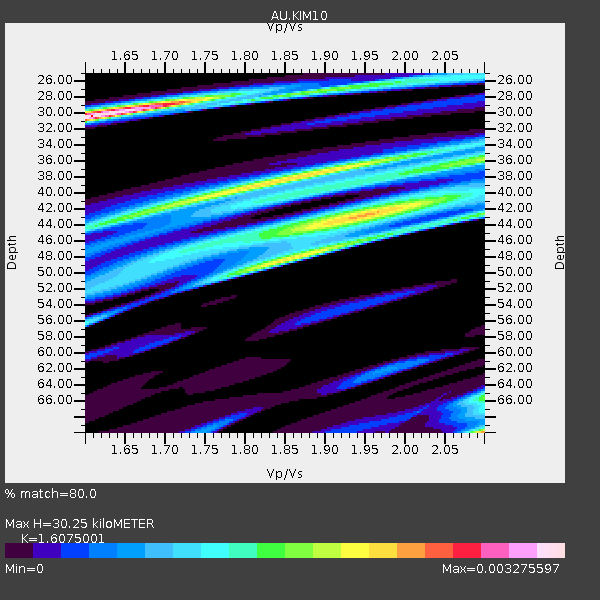
| Crust2 Type: | H7,early/mid Proter. shield, Austr., 1.5 km seds. |
| Thickness Estimate: | 30 km |
| Thickness StdDev: | 7.1 km |
| Vp/Vs Estimate: | 1.61 |
| Vp/Vs StdDev: | 0.19 |
| Vs Estimate: | 4.041 km/s |
| Poisson's Ratio: | 0.18 |
| Peak Value: | 0.00 |
| Assumed Vp: | 6.496 km/s |
| Ps Weight: | 0.33333334 |
| PpPs Weight: | 0.33333334 |
| PsPs Weight: | 0.33333328 |
| Residual Complexity: | 0.888 |
| Nearby stations H: | +- |
| (2.0 deg) Vp/Vs: | +- |
3 with match > 90% ( 18.75 %) and 3 with match > 80% ( 18.75 %) out of 16.
Download stack as xyz text file.
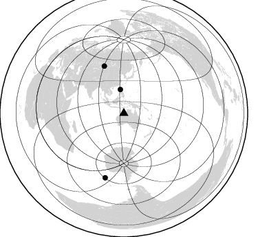
Azimuth Distribution of Events:
Prior Results for this Station
| Study | Thickness | Vp/Vs | Vp | Vs | Poissons Ratio | Extra |
| EARS | 30 km | 1.61 | 6.496 km/s | 4.041 km/s | 0.18 | |
| Crust2.0 | 38 km | 1.78 | 6.496 km/s | 3.647 km/s | 0.27 | H7,early/mid Proter. shield, Austr., 1.5 km seds. |
| Global Maxima | 30 km | 1.61 | 6.496 km/s | 4.041 km/s | 0.18 | amp=0.003275597 |
| Local Maxima 1 | 43 km | 1.95 | 6.496 km/s | 3.34 km/s | 0.32 | amp=0.0023206943 |
| Local Maxima 2 | 70 km | 2.10 | 6.496 km/s | 3.097 km/s | 0.35 | amp=0.0023134304 |
| Local Maxima 3 | 38 km | 1.86 | 6.496 km/s | 3.493 km/s | 0.30 | amp=0.0022584158 |
| Local Maxima 4 | 48 km | 1.85 | 6.496 km/s | 3.511 km/s | 0.29 | amp=0.0016808235 |
| Predicted Arrivals for vertical incidence (zero ray parameter) | |
| Ps | 2.83 SECOND |
| PpPs | 12.14 SECOND |
| PsPs/PpSs | 14.97 SECOND |
Events Processed for this Station
Download zip of receiver functions as SAC
Plot maxima for each earthquake.
Events Used in the Stack
(3 events)| Radial Match | Distance | Baz | FERegion | Time | Lat/Lon | Depth | Magnitude |
| 99.9983 | 34.7 deg | 351.771 deg | Luzon, Philippines | 2022/07/27 00:43:24 UTC | (17.6, 120.8) | 10 km | 7.0 Mww |
| 98.97228 | 73.9 deg | 337.49 deg | Russia-Mongolia Border Region | 2022/07/29 13:01:13 UTC | (50.4, 90.6) | 10 km | 5.6 Mww |
| 97.482956 | 97.8 deg | 196.299 deg | East Of South Sandwich Islands | 2022/09/29 03:03:29 UTC | (-60.6, -20.0) | 33 km | 6.7 Mi |
Losers
(13 events)| Radial Match | Distance | Baz | FERegion | Time | Lat/Lon | Depth | Magnitude | Reason |
| 99.91616 | 31.0 deg | 297.879 deg | Southern Sumatra, Indonesia | 2022/09/10 23:10:44 UTC | (-1.1, 98.6) | 20 km | 6.0 Mww | |
| 99.83438 | 41.2 deg | 98.3 deg | Vanuatu Islands | 2022/07/11 21:10:49 UTC | (-18.2, 169.0) | 10 km | 6.1 Mww | |
| 99.65846 | 52.0 deg | 118.365 deg | South Of Kermadec Islands | 2022/08/14 13:44:17 UTC | (-32.7, -179.0) | 10 km | 6.4 Mww | |
| 99.594475 | 42.0 deg | 102.908 deg | Southeast Of Loyalty Islands | 2022/09/14 11:04:07 UTC | (-21.2, 170.1) | 124 km | 7.0 Mi | |
| 85.08667 | 40.0 deg | 353.559 deg | Taiwan Region | 2022/09/17 14:45:27 UTC | (23.0, 121.2) | 10 km | 5.5 Mww | |
| 74.09732 | 31.0 deg | 298.087 deg | Southern Sumatra, Indonesia | 2022/08/29 03:29:13 UTC | (-1.0, 98.6) | 18 km | 5.9 mww | |
| 67.45866 | 80.9 deg | 144.411 deg | Pacific-Antarctic Ridge | 2022/08/30 09:09:44 UTC | (-54.7, -136.2) | 10 km | 6.2 Mww | |
| 63.25373 | 81.1 deg | 301.603 deg | Southern Iran | 2022/07/01 23:24:14 UTC | (26.9, 55.2) | 10 km | 6.1 mb | |
| 61.83759 | 80.9 deg | 144.193 deg | Pacific-Antarctic Ridge | 2022/08/30 08:00:00 UTC | (-54.5, -136.2) | 10 km | 5.5 Mww | |
| 58.65109 | 81.1 deg | 301.621 deg | Southern Iran | 2022/07/01 21:32:07 UTC | (26.9, 55.2) | 10 km | 6.1 mww | |
| 58.021366 | 81.1 deg | 301.591 deg | Southern Iran | 2022/07/01 23:25:15 UTC | (26.9, 55.3) | 10 km | 6.0 Mwb | |
| 56.66705 | 41.4 deg | 308.887 deg | Andaman Islands, India Region | 2022/07/04 09:07:04 UTC | (10.3, 94.2) | 10 km | 5.6 mb | |
| 47.06817 | 51.9 deg | 118.419 deg | South Of Kermadec Islands | 2022/08/29 18:10:50 UTC | (-32.7, -179.1) | 32 km | 5.8 mww |

