You are here: Home > Network List > AU - Australian Seismological Centre Stations List
> Station KIM06 GSWA station > Earthquake Result Viewer
KIM06 GSWA station - Earthquake Result Viewer
| Earthquake location: |
Tonga Islands Region |
| Earthquake latitude/longitude: |
-19.3/-172.1 |
| Earthquake time(UTC): |
2022/11/11 (315) 10:48:45 GMT |
| Earthquake Depth: |
25 km |
| Earthquake Magnitude: |
7.3 Mww |
| Earthquake Catalog/Contributor: |
NEIC PDE/us |
|
| Network: |
AU Australian Seismological Centre |
| Station: |
KIM06 GSWA station |
| Lat/Lon: |
18.51 S/123.46 E |
| Elevation: |
134 m |
|
| Distance: |
60.6 deg |
| Az: |
259.198 deg |
| Baz: |
102.155 deg |
| Ray Param: |
0.06137959 |
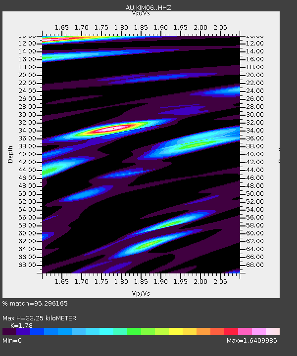
| Estimated Moho Depth: |
33.25 km |
| Estimated Crust Vp/Vs: |
1.78 |
| Assumed Crust Vp: |
6.347 km/s |
| Estimated Crust Vs: |
3.566 km/s |
| Estimated Crust Poisson's Ratio: |
0.27 |
|
| Radial Match: |
95.296165 % |
| Radial Bump: |
400 |
| Transverse Match: |
82.11283 % |
| Transverse Bump: |
400 |
| SOD ConfigId: |
29756493 |
| Insert Time: |
2022-11-25 10:57:31.623 +0000 |
| GWidth: |
2.5 |
| Max Bumps: |
400 |
| Tol: |
0.001 |
|

Signal To Noise
| Channel | StoN | STA | LTA |
| AU:KIM06: :HHZ:20221111T10:58:22.890025Z | 16.868864 | 4.462677E-6 | 2.6455118E-7 |
| AU:KIM06: :HHN:20221111T10:58:22.890025Z | 2.33787 | 7.5415426E-7 | 3.225818E-7 |
| AU:KIM06: :HHE:20221111T10:58:22.890025Z | 5.6445127 | 2.234709E-6 | 3.9590824E-7 |
| Arrivals |
| Ps | 4.3 SECOND |
| PpPs | 14 SECOND |
| PsPs/PpSs | 18 SECOND |


