You are here: Home > Network List > XA95 - Missouri to Massachusetts Transect Stations List
> Station MM10 Bellville, Ohio > Earthquake Result Viewer
MM10 Bellville, Ohio - Earthquake Result Viewer
| Earthquake location: |
Egypt |
| Earthquake latitude/longitude: |
28.8/34.9 |
| Earthquake time(UTC): |
1995/11/22 (326) 04:15:11 GMT |
| Earthquake Depth: |
10 km |
| Earthquake Magnitude: |
6.2 MB, 7.3 MS, 7.2 UNKNOWN, 6.2 ML |
| Earthquake Catalog/Contributor: |
WHDF/NEIC |
|
| Network: |
XA Missouri to Massachusetts Transect |
| Station: |
MM10 Bellville, Ohio |
| Lat/Lon: |
40.61 N/82.30 W |
| Elevation: |
346 m |
|
| Distance: |
89.7 deg |
| Az: |
317.366 deg |
| Baz: |
51.329 deg |
| Ray Param: |
0.041729063 |
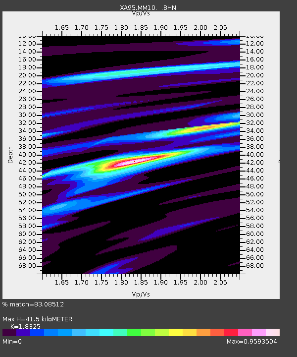
| Estimated Moho Depth: |
41.5 km |
| Estimated Crust Vp/Vs: |
1.83 |
| Assumed Crust Vp: |
6.498 km/s |
| Estimated Crust Vs: |
3.546 km/s |
| Estimated Crust Poisson's Ratio: |
0.29 |
|
| Radial Match: |
83.08512 % |
| Radial Bump: |
400 |
| Transverse Match: |
53.95254 % |
| Transverse Bump: |
400 |
| SOD ConfigId: |
29242 |
| Insert Time: |
2010-02-26 17:50:35.729 +0000 |
| GWidth: |
2.5 |
| Max Bumps: |
400 |
| Tol: |
0.001 |
|
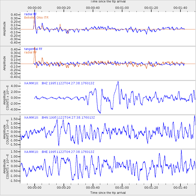
Signal To Noise
| Channel | StoN | STA | LTA |
| XA:MM10: :BHN:19951122T04:27:38.176013Z | 1.0730267 | 2.8211136E-7 | 2.6291178E-7 |
| XA:MM10: :BHE:19951122T04:27:38.176013Z | 0.86891884 | 3.0474203E-7 | 3.5071406E-7 |
| XA:MM10: :BHZ:19951122T04:27:38.176013Z | 1.8106283 | 3.9656678E-7 | 2.1902163E-7 |
| Arrivals |
| Ps | 5.4 SECOND |
| PpPs | 18 SECOND |
| PsPs/PpSs | 23 SECOND |


