
Station XA MM10 - Bellville, Ohio
Network: XA95 - Missouri to Massachusetts Transect
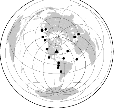
Nearby stations (2 deg radius)
| Station | Name | (Lat, Lon) | Start / End | Elevation |
| MM10 | Bellville, Ohio | (40.61, -82.30) | 1995-01-25 / 1996-04-10 | 346 m |
| Crust2 Type: | D9,Platform 1 km seds. |
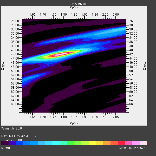
| Thickness Estimate: | 42 km |
| Thickness StdDev: | 0.2 km |
| Vp/Vs Estimate: | 1.80 |
| Vp/Vs StdDev: | 0.01 |
| Vs Estimate: | 3.62 km/s |
| Poisson's Ratio: | 0.27 |
| Peak Value: | 0.07 |
| Assumed Vp: | 6.498 km/s |
| Ps Weight: | 0.33333334 |
| PpPs Weight: | 0.33333334 |
| PsPs Weight: | 0.33333328 |
| Residual Complexity: | 0.422 |
| Nearby stations H: | +- |
| (2.0 deg) Vp/Vs: | +- |
11 with match > 90% ( 28.947369 %) and 19 with match > 80% ( 50.0 %) out of 38.
Download stack as xyz text file.
Azimuth Distribution of Events:
Prior Results for this Station
| Study | Thickness | Vp/Vs | Vp | Vs | Poissons Ratio | Extra |
| EARS | 42 km | 1.80 | 6.498 km/s | 3.62 km/s | 0.27 | |
| Crust2.0 | 41 km | 1.77 | 6.498 km/s | 3.666 km/s | 0.27 | D9,Platform 1 km seds. |
| MOMA | 38 km | 1.84 | 6.6 km/s | 3.587 km/s | 0.29 | |
| MOMA | 40 km | 1.80 | 6.6 km/s | 3.667 km/s | 0.28 | |
| MOMA | 42 km | 1.73 | 6.5 km/s | 3.757 km/s | 0.25 | |
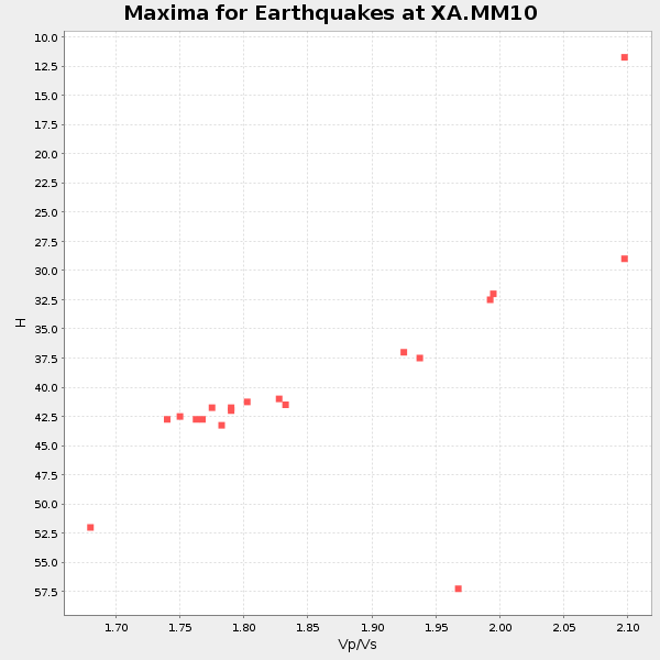
| Global Maxima | 42 km | 1.80 | 6.498 km/s | 3.62 km/s | 0.27 | amp=0.070573576 |
| Local Maxima 1 | 30 km | 2.10 | 6.498 km/s | 3.098 km/s | 0.35 | amp=0.022178084 |
| Local Maxima 2 | 41 km | 1.76 | 6.498 km/s | 3.697 km/s | 0.26 | amp=0.015026951 |
| Local Maxima 3 | 34 km | 1.82 | 6.498 km/s | 3.565 km/s | 0.28 | amp=0.013528874 |
| Local Maxima 4 | 53 km | 1.64 | 6.498 km/s | 3.95 km/s | 0.21 | amp=0.012017475 |
| Predicted Arrivals for vertical incidence (zero ray parameter) | |
| Ps | 5.11 SECOND |
| PpPs | 17.96 SECOND |
| PsPs/PpSs | 23.07 SECOND |
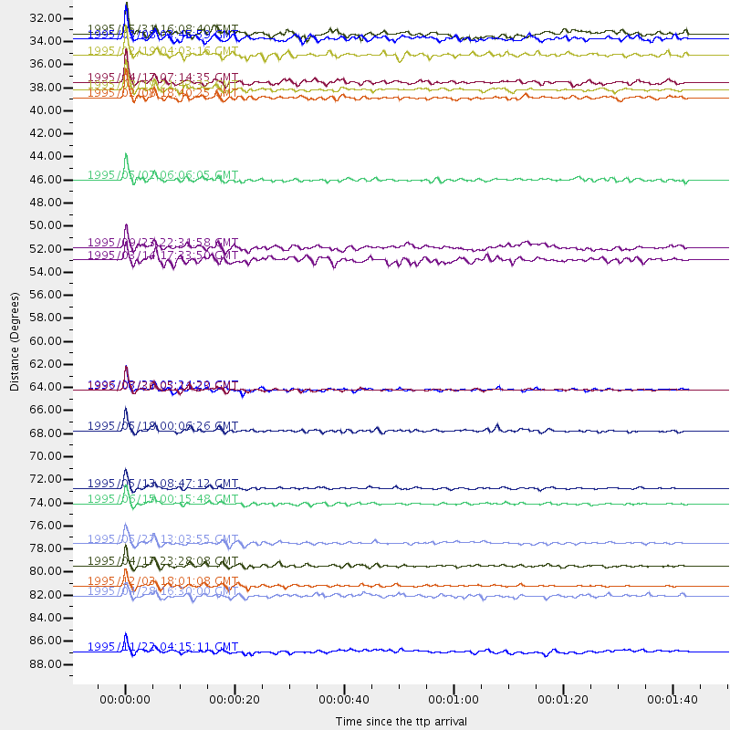
Events Processed for this Station
Download zip of receiver functions as SAC
Plot maxima for each earthquake.
Events Used in the Stack
(19 events)| Radial Match | Distance | Baz | FERegion | Time | Lat/Lon | Depth | Magnitude |
| 98.01091 | 64.6 deg | 167.8 deg | Near Coast Of Northern Chile | 1995/07/30 05:11:23 GMT | (-23.4, -70.3) | 47 km | 6.6 MB, 7.3 MS, 7.2 UNKNOWN, 8.1 MW |
| 96.44814 | 75.5 deg | 51.768 deg | Greece | 1995/06/15 00:15:48 GMT | (38.4, 22.3) | 14 km | 6.0 MB, 6.5 MS, 6.5 UNKNOWN, 5.7 ML |
| 96.056 | 68.5 deg | 111.008 deg | Central Mid-Atlantic Ridge | 1995/05/18 00:06:26 GMT | (-0.9, -22.0) | 10 km | 6.2 MB, 6.1 MS, 6.8 UNKNOWN, 6.7 MW |
| 95.33872 | 35.9 deg | 168.707 deg | Colombia | 1995/08/19 21:43:32 GMT | (5.1, -75.7) | 125 km | 6.1 MB, 6.6 UNKNOWN, 6.5 MW |
| 94.69866 | 79.3 deg | 333.884 deg | Sakhalin, Russia | 1995/05/27 13:03:55 GMT | (52.6, 142.8) | 33 km | 6.6 MB, 7.6 MS, 7.0 UNKNOWN, 7.0 MW |
| 94.609474 | 74.0 deg | 50.691 deg | Greece | 1995/05/13 08:47:12 GMT | (40.1, 21.7) | 13 km | 6.2 MB, 6.5 MS, 6.6 UNKNOWN, 6.5 MD |
| 93.15985 | 36.6 deg | 170.516 deg | Colombia | 1995/02/08 18:40:25 GMT | (4.2, -76.6) | 69 km | 6.3 MB, 6.4 UNKNOWN, 6.0 MD |
| 91.62864 | 44.5 deg | 172.383 deg | Northern Peru | 1995/05/02 06:06:05 GMT | (-3.9, -77.0) | 103 km | 6.5 MB, 6.7 UNKNOWN, 6.6 MW |
| 91.07708 | 81.4 deg | 325.369 deg | Kuril Islands | 1995/04/17 23:28:08 GMT | (45.9, 151.3) | 34 km | 6.1 MB, 6.3 MS, 6.2 UNKNOWN, 6.8 MW |
| 90.333405 | 32.6 deg | 284.309 deg | Off Coast Of Northern California | 1995/02/19 04:03:16 GMT | (40.6, -125.5) | 10 km | 6.1 MB, 6.8 MS, 6.7 UNKNOWN, 6.6 MD |
| 90.15252 | 83.3 deg | 325.627 deg | Kuril Islands | 1995/12/03 18:01:08 GMT | (44.6, 149.4) | 33 km | 6.6 MB, 8.0 MS |
| 89.93215 | 64.6 deg | 316.551 deg | Rat Islands, Aleutian Islands | 1996/03/22 03:24:20 GMT | (51.2, 178.7) | 20 km | 5.7 MB, 6.6 MS, 6.8 UNKNOWN, 6.6 ML |
| 89.18624 | 35.2 deg | 86.934 deg | Northern Mid-Atlantic Ridge | 1995/04/17 07:14:35 GMT | (33.8, -38.6) | 10 km | 5.8 MB, 5.8 MS, 5.9 UNKNOWN, 6.1 MW |
| 89.004456 | 31.0 deg | 134.015 deg | Leeward Islands | 1995/03/08 03:45:59 GMT | (16.6, -59.6) | 15 km | 6.3 MB, 6.2 MS, 6.4 UNKNOWN, 6.1 MD |
| 84.65499 | 51.0 deg | 175.435 deg | Near Coast Of Peru | 1995/09/23 22:31:58 GMT | (-10.5, -78.7) | 73 km | 5.9 MB, 6.5 UNKNOWN, 6.4 MW |
| 83.702194 | 52.2 deg | 313.997 deg | Alaska Peninsula | 1995/03/14 17:33:50 GMT | (54.8, -161.3) | 33 km | 6.1 MB, 5.9 MS, 6.2 UNKNOWN, 5.5 ML |
| 83.08512 | 89.7 deg | 51.329 deg | Egypt | 1995/11/22 04:15:11 GMT | (28.8, 34.9) | 10 km | 6.2 MB, 7.3 MS, 7.2 UNKNOWN, 6.2 ML |
| 80.06462 | 84.3 deg | 326.087 deg | Kuril Islands | 1995/04/28 16:30:00 GMT | (44.1, 148.1) | 29 km | 6.6 MB, 6.9 MS, 7.0 UNKNOWN, 6.8 MW |
| 80.0569 | 30.5 deg | 232.366 deg | Off Coast Of Jalisco, Mexico | 1995/05/31 16:08:40 GMT | (18.9, -107.4) | 33 km | 5.4 MB, 6.1 MS, 6.3 UNKNOWN, 6.3 MW |
Losers
(19 events)| Radial Match | Distance | Baz | FERegion | Time | Lat/Lon | Depth | Magnitude | Reason |
| 97.14845 | 84.3 deg | 326.067 deg | Kuril Islands | 1995/04/28 17:08:43 GMT | (44.1, 148.1) | 33 km | 6.2 MB, 6.2 MS | |
| 75.48283 | 57.3 deg | 313.13 deg | Fox Islands, Aleutian Islands | 1996/03/30 13:05:17 GMT | (52.2, -168.7) | 33 km | 5.9 MB, 6.2 MS, 6.3 UNKNOWN, 6.1 ML | |
| 73.73249 | 39.3 deg | 184.147 deg | Off Coast Of Ecuador | 1995/04/27 12:44:38 GMT | (1.2, -84.9) | 10 km | 5.3 MB, 6.0 MS, 6.2 UNKNOWN, 6.2 MW | |
| 73.113 | 64.5 deg | 168.07 deg | Near Coast Of Northern Chile | 1995/07/30 21:05:50 GMT | (-23.3, -70.6) | 33 km | 5.6 MB, 5.6 MS, 5.4 UNKNOWN, 6.1 MW | |
| 71.38346 | 73.3 deg | 325.703 deg | Off East Coast Of Kamchatka | 1995/04/01 05:50:20 GMT | (52.3, 159.1) | 47 km | 5.9 MB, 5.6 MS, 5.3 UNKNOWN, 6.0 MW | |
| 70.88115 | 83.6 deg | 48.669 deg | Cyprus Region | 1995/02/23 21:03:02 GMT | (35.0, 32.3) | 15 km | 5.8 MB, 5.7 MS, 5.9 UNKNOWN, 5.8 MW | |
| 68.69463 | 64.3 deg | 168.047 deg | Near Coast Of Northern Chile | 1995/08/03 01:57:21 GMT | (-23.1, -70.6) | 33 km | 5.4 MB, 5.9 MS, 5.7 UNKNOWN, 6.3 MW | |
| 67.80924 | 41.6 deg | 174.623 deg | Ecuador | 1996/03/28 23:03:49 GMT | (-1.0, -78.7) | 33 km | 5.8 MB, 5.2 MS, 5.9 UNKNOWN, 5.1 MS | |
| 65.49135 | 69.7 deg | 167.695 deg | Chile-Argentina Border Region | 1995/08/03 08:18:53 GMT | (-28.3, -69.2) | 104 km | 5.9 MB, 5.8 UNKNOWN, 5.9 MW | |
| 65.35417 | 97.5 deg | 16.124 deg | Southern Xinjiang, China | 1996/03/19 15:00:26 GMT | (40.0, 76.7) | 28 km | 5.7 MB, 6.0 MS, 6.3 UNKNOWN, 6.1 MW | |
| 62.38349 | 77.9 deg | 325.538 deg | Kuril Islands | 1995/06/29 07:45:09 GMT | (48.8, 154.5) | 62 km | 5.9 MB, 6.0 UNKNOWN, 6.0 MW | |
| 62.07162 | 52.1 deg | 174.109 deg | Near Coast Of Peru | 1995/06/21 16:33:05 GMT | (-11.5, -77.6) | 70 km | 5.5 MB | |
| 60.320724 | 82.6 deg | 350.604 deg | East Of Lake Baykal, Russia | 1995/11/13 08:43:14 GMT | (56.1, 114.5) | 24 km | 5.9 MB, 5.6 MS, 5.8 UNKNOWN | |
| 58.801273 | 53.8 deg | 313.216 deg | Unimak Island Region, Alaska | 1995/07/08 17:15:28 GMT | (53.6, -163.5) | 33 km | 5.8 MB, 5.7 MS, 5.5 UNKNOWN, 6.0 MW | |
| 57.48112 | 64.4 deg | 168.027 deg | Near Coast Of Northern Chile | 1995/08/02 00:14:09 GMT | (-23.2, -70.6) | 33 km | 5.4 MB, 5.5 MS, 5.3 UNKNOWN | |
| 54.370564 | 83.1 deg | 328.859 deg | Sea Of Okhotsk | 1995/02/18 13:29:06 GMT | (46.7, 145.9) | 355 km | 5.6 MB, 5.7 UNKNOWN, 5.5 MW | |
| 50.87254 | 62.8 deg | 165.76 deg | Chile-Bolivia Border Region | 1995/09/19 03:31:53 GMT | (-21.2, -68.7) | 110 km | 5.7 MB, 5.7 UNKNOWN, 5.6 MW | |
| 46.110626 | 94.5 deg | 331.321 deg | Sea Of Japan | 1995/03/31 14:01:40 GMT | (38.2, 135.1) | 365 km | 6.0 MB, 6.2 UNKNOWN, 6.3 MW | |
| 38.60687 | 84.8 deg | 325.74 deg | East Of Kuril Islands | 1996/03/09 16:15:36 GMT | (43.4, 148.0) | 33 km | 5.6 MB, 5.9 MS, 6.1 UNKNOWN, 5.5 MS |
