You are here: Home > Network List > XA95 - Missouri to Massachusetts Transect Stations List
> Station MM10 Bellville, Ohio > Earthquake Result Viewer
MM10 Bellville, Ohio - Earthquake Result Viewer
| Earthquake location: |
Kuril Islands |
| Earthquake latitude/longitude: |
44.6/149.4 |
| Earthquake time(UTC): |
1995/12/03 (337) 18:01:08 GMT |
| Earthquake Depth: |
33 km |
| Earthquake Magnitude: |
6.6 MB, 8.0 MS |
| Earthquake Catalog/Contributor: |
WHDF/NEIC |
|
| Network: |
XA Missouri to Massachusetts Transect |
| Station: |
MM10 Bellville, Ohio |
| Lat/Lon: |
40.61 N/82.30 W |
| Elevation: |
346 m |
|
| Distance: |
83.3 deg |
| Az: |
36.963 deg |
| Baz: |
325.627 deg |
| Ray Param: |
0.046218745 |
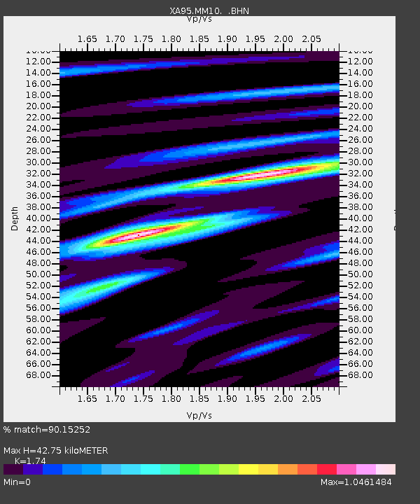
| Estimated Moho Depth: |
42.75 km |
| Estimated Crust Vp/Vs: |
1.74 |
| Assumed Crust Vp: |
6.498 km/s |
| Estimated Crust Vs: |
3.734 km/s |
| Estimated Crust Poisson's Ratio: |
0.25 |
|
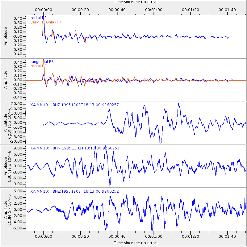
| Radial Match: |
90.15252 % |
| Radial Bump: |
400 |
| Transverse Match: |
89.032486 % |
| Transverse Bump: |
400 |
| SOD ConfigId: |
6273 |
| Insert Time: |
2010-02-26 17:50:36.975 +0000 |
| GWidth: |
2.5 |
| Max Bumps: |
400 |
| Tol: |
0.001 |
|
Signal To Noise
| Channel | StoN | STA | LTA |
| XA:MM10: :BHN:19951203T18:13:00.926025Z | 2.029003 | 1.7312974E-6 | 8.5327497E-7 |
| XA:MM10: :BHE:19951203T18:13:00.926025Z | 0.6739957 | 5.2592395E-7 | 7.803076E-7 |
| XA:MM10: :BHZ:19951203T18:13:00.926025Z | 2.1746614 | 1.9629142E-6 | 9.0262984E-7 |
| Arrivals |
| Ps | 5.0 SECOND |
| PpPs | 18 SECOND |
| PsPs/PpSs | 23 SECOND |


