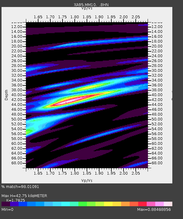
MM10 Bellville, Ohio - Earthquake Result Viewer
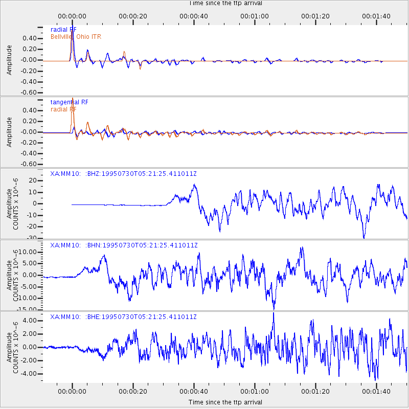
Earthquake location: Near Coast Of Northern Chile
Earthquake latitude/longitude: -23.4/-70.3
Earthquake time(UTC): 1995/07/30 (211) 05:11:23 GMT
Earthquake Depth: 47 km
Earthquake Magnitude: 6.6 MB, 7.3 MS, 7.2 UNKNOWN, 8.1 MW
Earthquake Catalog/Contributor: WHDF/NEIC
Network: XA Missouri to Massachusetts Transect
Station: MM10 Bellville, Ohio
Lat/Lon: 40.61 N/82.30 W
Elevation: 346 m
Distance: 64.6 deg
Az: 349.918 deg
Baz: 167.8 deg
Ray Param: 0.05871043
Estimated Moho Depth: 42.75 km
Estimated Crust Vp/Vs: 1.76
Assumed Crust Vp: 6.498 km/s
Estimated Crust Vs: 3.687 km/s
Estimated Crust Poisson's Ratio: 0.26
Radial Match: 98.01091 %
Radial Bump: 280
Transverse Match: 89.440346 %
Transverse Bump: 400
SOD ConfigId: 6273
Insert Time: 2010-02-26 17:50:39.604 +0000
GWidth: 2.5
Max Bumps: 400
Tol: 0.001

Signal To Noise

ChannelStoNSTALTA
XA:MM10: :BHN:19950730T05:21:25.411011Z8.0193851.8534988E-62.3112729E-7
XA:MM10: :BHE:19950730T05:21:25.411011Z2.67920542.8689948E-71.0708379E-7
XA:MM10: :BHZ:19950730T05:21:25.411011Z18.402184.186363E-62.2749279E-7
Arrivals
Ps5.2 SECOND
PpPs17 SECOND
PsPs/PpSs23 SECOND