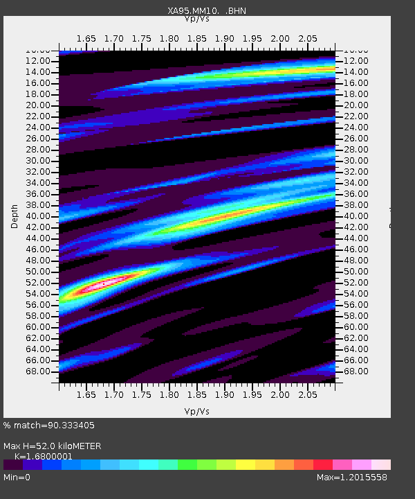
MM10 Bellville, Ohio - Earthquake Result Viewer
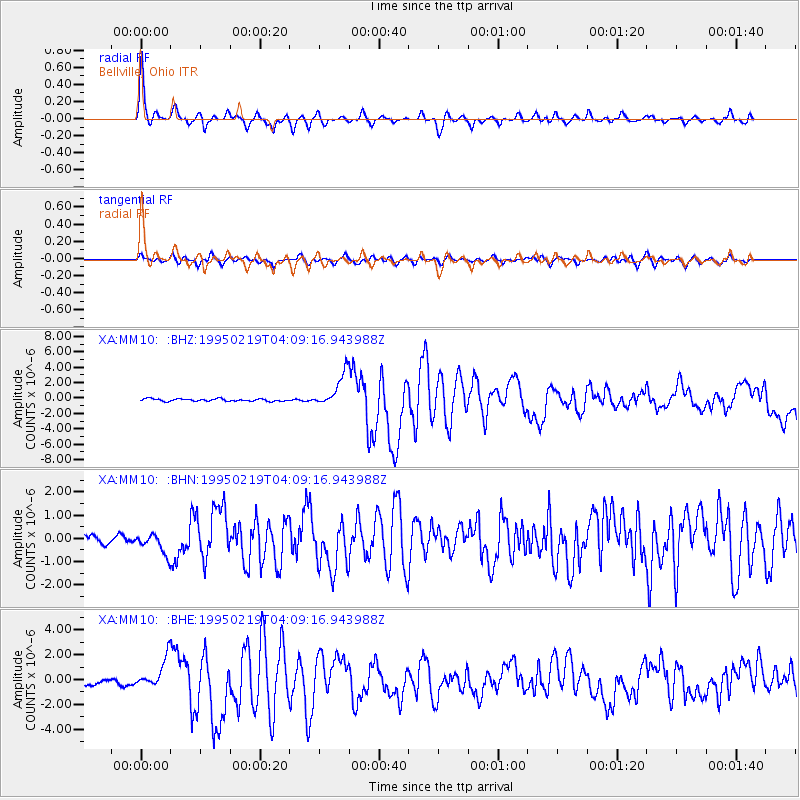
Earthquake location: Off Coast Of Northern California
Earthquake latitude/longitude: 40.6/-125.5
Earthquake time(UTC): 1995/02/19 (050) 04:03:16 GMT
Earthquake Depth: 10 km
Earthquake Magnitude: 6.1 MB, 6.8 MS, 6.7 UNKNOWN, 6.6 MD
Earthquake Catalog/Contributor: WHDF/NEIC
Network: XA Missouri to Massachusetts Transect
Station: MM10 Bellville, Ohio
Lat/Lon: 40.61 N/82.30 W
Elevation: 346 m
Distance: 32.6 deg
Az: 75.51 deg
Baz: 284.309 deg
Ray Param: 0.078591295
Estimated Moho Depth: 52.0 km
Estimated Crust Vp/Vs: 1.68
Assumed Crust Vp: 6.498 km/s
Estimated Crust Vs: 3.868 km/s
Estimated Crust Poisson's Ratio: 0.23
Radial Match: 90.333405 %
Radial Bump: 400
Transverse Match: 77.85001 %
Transverse Bump: 400
SOD ConfigId: 6273
Insert Time: 2010-02-26 17:50:55.866 +0000
GWidth: 2.5
Max Bumps: 400
Tol: 0.001

Signal To Noise

ChannelStoNSTALTA
XA:MM10: :BHN:19950219T04:09:16.943988Z1.87506034.5080586E-72.4042205E-7
XA:MM10: :BHE:19950219T04:09:16.943988Z4.55716941.2279892E-62.6946313E-7
XA:MM10: :BHZ:19950219T04:09:16.943988Z14.2660132.1753856E-61.5248727E-7
Arrivals
Ps5.9 SECOND
PpPs20 SECOND
PsPs/PpSs26 SECOND