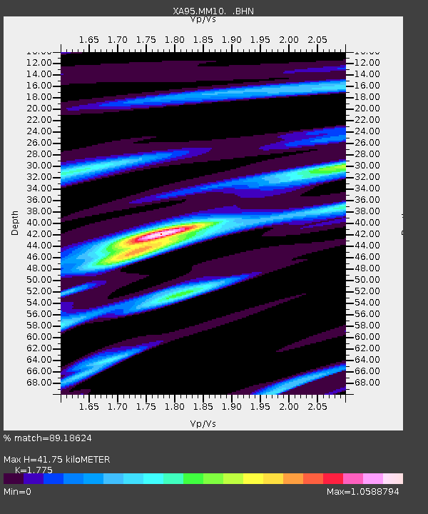
MM10 Bellville, Ohio - Earthquake Result Viewer
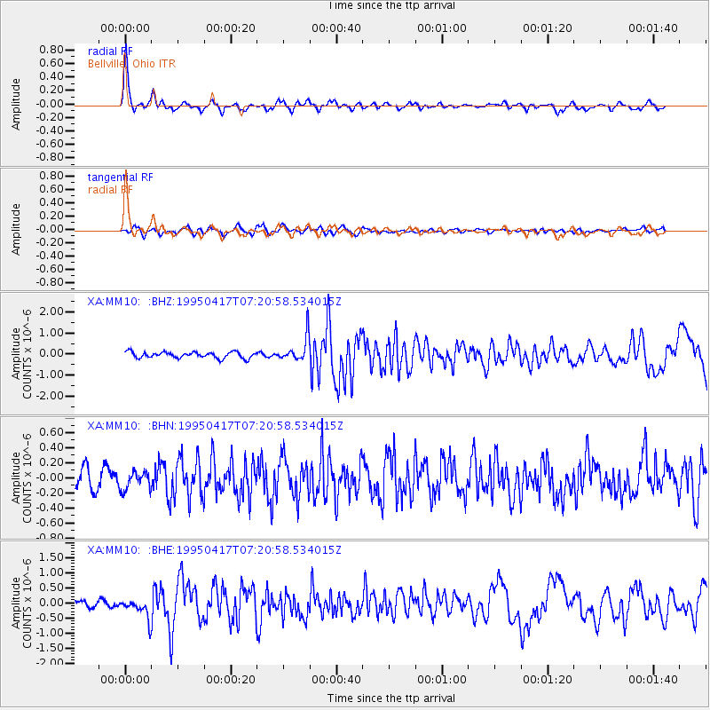
Earthquake location: Northern Mid-Atlantic Ridge
Earthquake latitude/longitude: 33.8/-38.6
Earthquake time(UTC): 1995/04/17 (107) 07:14:35 GMT
Earthquake Depth: 10 km
Earthquake Magnitude: 5.8 MB, 5.8 MS, 5.9 UNKNOWN, 6.1 MW
Earthquake Catalog/Contributor: WHDF/NEIC
Network: XA Missouri to Massachusetts Transect
Station: MM10 Bellville, Ohio
Lat/Lon: 40.61 N/82.30 W
Elevation: 346 m
Distance: 35.2 deg
Az: 294.124 deg
Baz: 86.934 deg
Ray Param: 0.0773523
Estimated Moho Depth: 41.75 km
Estimated Crust Vp/Vs: 1.77
Assumed Crust Vp: 6.498 km/s
Estimated Crust Vs: 3.661 km/s
Estimated Crust Poisson's Ratio: 0.27
Radial Match: 89.18624 %
Radial Bump: 388
Transverse Match: 65.30924 %
Transverse Bump: 400
SOD ConfigId: 6273
Insert Time: 2010-02-26 17:50:57.476 +0000
GWidth: 2.5
Max Bumps: 400
Tol: 0.001

Signal To Noise

ChannelStoNSTALTA
XA:MM10: :BHN:19950417T07:20:58.534015Z0.820518731.17014196E-71.4261002E-7
XA:MM10: :BHE:19950417T07:20:58.534015Z2.74693783.1957674E-71.1633927E-7
XA:MM10: :BHZ:19950417T07:20:58.534015Z4.08042055.926416E-71.4524032E-7
Arrivals
Ps5.4 SECOND
PpPs16 SECOND
PsPs/PpSs22 SECOND